|
|
| La Crosse Municipal Airport |
 |
| FAA airport diagram |
| IATA: LSE – ICAO: KLSE – FAA LID: LSE |
| Summary |
| Airport type |
Public |
| Owner |
City of La Crosse |
| Serves |
La Crosse, Wisconsin |
| Elevation AMSL |
655 ft / 200 m |
| Coordinates |
43°52′45″N 091°15′24″W / 43.87917°N 91.25667°W / 43.87917; -91.25667 |
| Website |
cityoflacrosse.org/... |
| Runways |
| Direction |
Length |
Surface |
| ft |
m |
| 3/21 |
5,199 |
1,585 |
Asphalt |
| 13/31 |
6,050 |
1,844 |
Concrete |
| 18/36 |
8,742 |
2,665 |
Concrete |
| Statistics (2006) |
| Aircraft operations |
45,646 |
| Based aircraft |
91 |
| Source: Federal Aviation Administration |
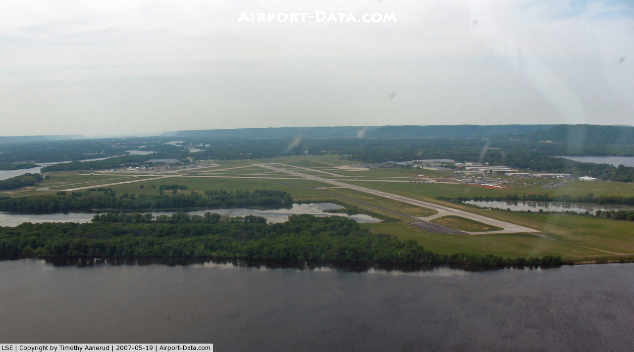
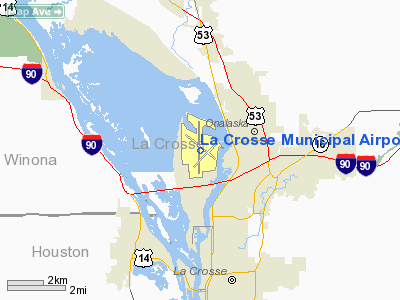
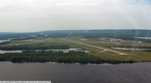
La Crosse Municipal Airport (IATA: LSE, ICAO: KLSE, FAA LID: LSE) is a city-owned, public-use airport located four nautical miles (7 km) northwest of the central business district of La Crosse, a city in La Crosse County, Wisconsin, United States.
It occupies the northern area of French Island, next to the Mississippi River. The airport serves the La Crosse Metropolitan Area, including the surrounding three-state area of west-central Wisconsin, southeastern Minnesota and northeastern Iowa. La Crosse's airport is the closest scheduled passenger service airport to the U.S. Army Fort McCoy military base near Sparta, Wisconsin. Overview
Two major airlines, Delta Air Lines (now merged with Northwest Airlines) served by Delta Connection airlines; and American Airlines served by American Eagle Airlines, provide 11 daily departures and arrivals with direct service to three connecting cities: Chicago, Minneapolis, and Detroit. Sun Country Airlines and Xtra Airways provide periodic Boeing 737 jet charter services to Laughlin and Elko, Nevada, often referred to as "the casino express". In 2004, the airport served about 500,000 passengers and recorded 44,000 aircraft operations.
There are 88 aircraft based at the airport, 11 corporate hangars and eight multi-aircraft T-hangars on the airport property. There is a cellphone use free parking area for those awaiting passenger arrivals at the main passenger terminal.
Facilities and operations
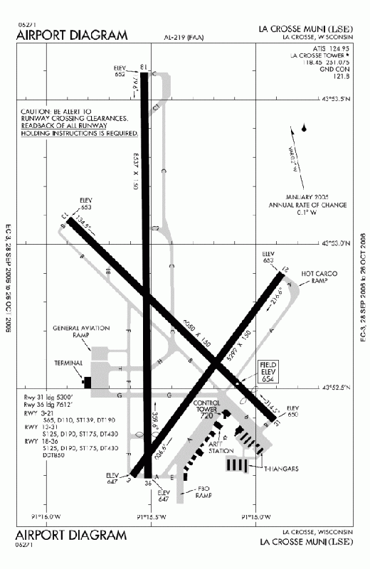
La Crosse Municipal Airport covers an area of 1,380 acres (558 ha) at an elevation of 655 feet (200 m) above mean sea level. It has three runways: 3/21 is 5,199 by 150 feet (1,585 x 46 m) with an asphalt surface; 13/31 is 6,050 by 150 feet (1,844 x 46 m) with a concrete surface; and 18/36 is 8,742 by 150 feet (2,665 x 46 m) with a concrete surface.
The original runway layout is still in use, but over time many improvements have taken place. Two of the runways were extended to 6,050 feet (1,840 m) and 8,742 feet (2,665 m). The 8,742-foot paved runway is the fourth longest in Wisconsin.
For the 12-month period ending December 31, 2006, the airport had 45,646 aircraft operations, an average of 125 per day: 71% general aviation, 21% air taxi, 4% scheduled commercial and 4% military. At that time there were 91 aircraft based at this airport: 80% single-engine, 9% multi-engine, 10% jet and 1% helicopter.
The airport has a modern two-story passenger terminal with three passenger gates. The following services are provided in the terminal:
- Delta Air Lines passenger counter and kiosk
- American Eagle Airlines passenger counter
- Avis car rental
- Hertz car rental
- National Alamo car rental
- Enterprise Car Rental (shuttle to downtown)
- LSE Airport Gift Shop
- Vinney's Runway Restaurant
- Meeting rooms
Scheduled Airlines, aircraft and destinations
The La Crosse airport is served by Delta Connection's 50-seat Bombardier CRJ200 and the newer 76-seat Bombardier CRJ900 and Embraer 175 regional jets (both with regional jet uncommon 1st class seats). American Eagle also flies 50-seat Embraer 145 and larger CRJ700 regional passenger planes from Chicago.
Scheduled airlines serving the La Crosse Airport include:
| Airlines |
Destinations |
| American Eagle |
Chicago-O'Hare |
| Delta Connection operated by Compass Airlines |
Minneapolis/St. Paul |
| Delta Connection operated by Mesaba Airlines |
Minneapolis/St. Paul |
| Delta Connection operated by Pinnacle Airlines |
Detroit, Minneapolis/St. Paul |
| Sun Country Airlines |
Laughlin (NV) |
| Xtra Airways |
Elko (NV) |
Unusual History
The La Crosse Airport can accommodate the world's largest aircraft in service today. One of the world's largest passenger jumbo jets, the Boeing 747 Air Force One (AF1), has made overnight trips to this airport with every U.S. President for the last 20 years.
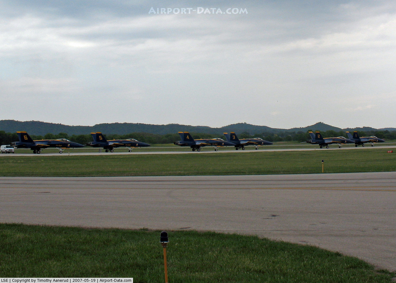
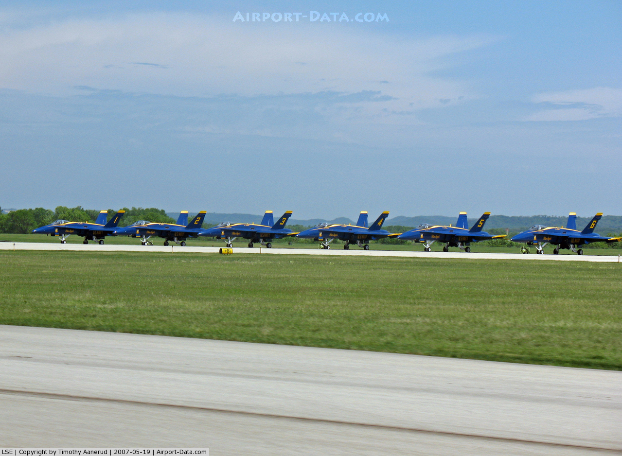
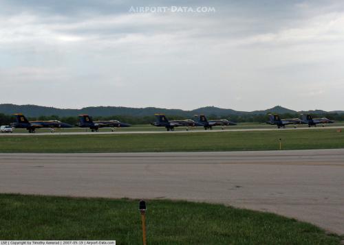
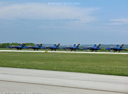
In 1998, President Bill Clinton flew to La Crosse in another AF1 Boeing 707 (VC-137C SAM 26000) older large jet, which was the same plane that carried the deceased body of late President John F. Kennedy from Dallas to Washington and the only plane on which a U.S. president was sworn into office. This was the last time a U.S. President flew on this plane, as it was then retired to the National Museum of the United States Air Force in Dayton, Ohio. One of the world's largest cargo jets, a Russian Antonov An-124, has flown to the La Crosse airport when heavy transport was needed for the international flight of local businesses. The large U.S. military C-5A cargo and KC-10 Extender cargo/refueling jumbo jets have been at the annual summer Deke Slayton Airshow (area astronaut), Airfest at the airport, along with vintage and modern military and private planes of all kinds. The show has also featured performances by the U.S. Navy Blue Angels and the U.S. Air Force Thunderbirds. In the past, Sun Country airline has flown the large DC-10 (380 passenger seats) on charter flights from La Crosse to other cities. The New Orleans Saints NFL football team flew the 250-seat Delta Air Lines Boeing 757 planes each week to La Crosse for summer camp and to and from NFL cities for pre-season games.
The above content comes from Wikipedia and is published under free licenses – click here to read more.
 |
(Click on the photo to enlarge) |
 |
(Click on the photo to enlarge) |
 |
(Click on the photo to enlarge) |
 |
(Click on the photo to enlarge) |
 |
(Click on the photo to enlarge) |
Location & QuickFacts
| FAA Information Effective: | 2008-09-25 |
| Airport Identifier: | LSE |
| Airport Status: | Operational |
| Longitude/Latitude: | 091-15-23.9000W/43-52-45.6000N
-91.256639/43.879333 (Estimated) |
| Elevation: | 655 ft / 199.64 m (Surveyed) |
| Land: | 1380 acres |
| From nearest city: | 4 nautical miles NW of La Crosse, WI |
| Location: | La Crosse County, WI |
| Magnetic Variation: | 02E (1985) |
Owner & Manager
| Ownership: | Publicly owned |
| Owner: | City Of La Crosse |
| Address: | 2850 Airport Road
La Crosse, WI 54603 |
| Phone number: | 608-789-7464 |
| Manager: | Dan Wruck |
| Address: | 2850 Airport Road
La Crosse, WI 54603-1264 |
| Phone number: | 608-789-7464 |
Airport Operations and Facilities
| Airport Use: | Open to public |
| Wind indicator: | Yes |
| Segmented Circle: | Yes |
| Control Tower: | Yes |
| Lighting Schedule: | DUSK-DAWN
WHEN ATCT CLSD HIRL RY 13/31 PRESET LOW INTST; TO INCR INTST & ACTVT HIRL RYS 18/36 & 03/21; REIL RYS 13 & 36; MALSR RY 18 - CTAF. |
| Beacon Color: | Clear-Green (lighted land airport) |
| Landing fee charge: | No |
| Sectional chart: | Chicago |
| Region: | AGL - Great Lakes |
| Boundary ARTCC: | ZMP - Minneapolis |
| Tie-in FSS: | GRB - Green Bay |
| FSS Toll Free: | 1-800-WX-BRIEF |
| NOTAMs Facility: | LSE (NOTAM-d service avaliable) |
| Certification type/date: | I B S 05/1973 |
| Federal Agreements: | NGSY3 |
Airport Communications
| CTAF: | 118.450 |
| Unicom: | 122.950 |
Airport Services
| Fuel available: | 100LLA |
| Airframe Repair: | MAJOR |
| Power Plant Repair: | MAJOR |
| Bottled Oxygen: | NONE |
| Bulk Oxygen: | NONE |
Runway Information
Runway 03/21
| Dimension: | 5299 x 150 ft / 1615.1 x 45.7 m |
| Surface: | ASPH, Fair Condition |
| Weight Limit: | Single wheel: 65000 lbs.
Dual wheel: 110000 lbs.
Dual tandem wheel: 190000 lbs. |
| Edge Lights: | High |
| |
Runway 03 |
Runway 21 |
| Longitude: | 091-15-35.3172W | 091-14-52.3860W |
| Latitude: | 43-52-11.8761N | 43-52-54.0132N |
| Elevation: | 647.00 ft | 653.00 ft |
| Alignment: | 36 | 127 |
| Traffic Pattern: | Left | Left |
| Markings: | Non-precision instrument, Fair Condition | Non-precision instrument, Fair Condition |
| Crossing Height: | 40.00 ft | 40.00 ft |
| VASI: | 4-light PAPI on left side | 4-light PAPI on left side |
| Visual Glide Angle: | 4.00° | 4.00° |
| Runway End Identifier: | No | No |
| Centerline Lights: | No | No |
| Touchdown Lights: | No | No |
| Obstruction: | 47 ft pole, 1406.0 ft from runway, 357 ft left of centerline, 25:1 slope to clear | 49 ft trees, 983.0 ft from runway, 367 ft right of centerline, 15:1 slope to clear |
|
Runway 13/31
| Dimension: | 6050 x 150 ft / 1844.0 x 45.7 m |
| Surface: | ASPH, Fair Condition |
| Surface Treatment: | Saw-cut or plastic Grooved |
| Weight Limit: | Single wheel: 125000 lbs.
Dual wheel: 190000 lbs.
Dual tandem wheel: 430000 lbs. |
| Edge Lights: | High |
| |
Runway 13 |
Runway 31 |
| Longitude: | 091-15-51.5308W | 091-14-52.4825W |
| Latitude: | 43-53-06.2001N | 43-52-24.4254N |
| Elevation: | 655.00 ft | 650.00 ft |
| Alignment: | 127 | 127 |
| Traffic Pattern: | Left | Left |
| Markings: | Non-precision instrument, Good Condition | Non-precision instrument, Good Condition |
| Crossing Height: | 32.00 ft | 59.00 ft |
| Displaced threshold: | 0.00 ft | 739.00 ft |
| VASI: | 4-box on left side | 4-box on left side |
| Visual Glide Angle: | 3.00° | 3.60° |
| Runway End Identifier: | Yes | No |
| Centerline Lights: | No | No |
| Touchdown Lights: | No | No |
| Obstruction: | 77 ft trees, 2832.0 ft from runway, 390 ft left of centerline, 34:1 slope to clear | 92 ft tower, 1910.0 ft from runway, 615 ft right of centerline, 18:1 slope to clear
RY 31 APCH RATIO 37:1 AT DSPLCD THLD. |
| Decleard distances: | Take off run available 5300.00 ft
Take off distance available 5300.00 ft
Actual stop distance available 5300.00 ft
Landing distance available 5300.00 ft
| Take off run available 6050.00 ft
Take off distance available 6050.00 ft
Actual stop distance available 6050.00 ft
Landing distance available 5300.00 ft
|
|
Runway 18/36
| Dimension: | 8536 x 150 ft / 2601.8 x 45.7 m |
| Surface: | CONC, Good Condition |
| Surface Treatment: | Saw-cut or plastic Grooved |
| Weight Limit: | Single wheel: 125000 lbs.
Dual wheel: 190000 lbs.
Dual tandem wheel: 430000 lbs.
Dual dual tandem wheel: 850000 lbs. |
| Edge Lights: | High |
| |
Runway 18 |
Runway 36 |
| Longitude: | 091-15-31.9518W | 091-15-30.8344W |
| Latitude: | 43-53-35.6952N | 43-52-11.4035N |
| Elevation: | 652.00 ft | 647.00 ft |
| Alignment: | 127 | 127 |
| ILS Type: | ILS
| |
| Traffic Pattern: | Left | Left |
| Markings: | Precision instrument, Good Condition | Precision instrument, Good Condition |
| Crossing Height: | 55.00 ft | 28.00 ft |
| Displaced threshold: | 0.00 ft | 925.00 ft |
| VASI: | 4-light PAPI on left side | 4-box on left side |
| Visual Glide Angle: | 3.00° | 3.00° |
| Approach lights: | MALSR | |
| Runway End Identifier: | No | Yes |
| Centerline Lights: | No | No |
| Touchdown Lights: | No | No |
| Obstruction: | , 50:1 slope to clear | 70 ft tree, 1598.0 ft from runway, 411 ft left of centerline, 20:1 slope to clear
RWY 36 APCH RATIO 36:1 AT DSPLCD THLD. |
| Decleard distances: | Take off run available 8536.00 ft
Take off distance available 8536.00 ft
Actual stop distance available 8536.00 ft
Landing distance available 8536.00 ft
| Take off run available 8536.00 ft
Take off distance available 8536.00 ft
Actual stop distance available 8351.00 ft
Landing distance available 7426.00 ft
|
|
Radio Navigation Aids
| ID |
Type |
Name |
Ch |
Freq |
Var |
Dist |
| CHU | NDB | Caledonia | | 209.00 | 03E | 20.3 nm |
| CMY | NDB | Mccoy | | 412.00 | 00E | 26.9 nm |
| BCK | NDB | Black River Falls | | 362.00 | 00E | 28.6 nm |
| DEH | NDB | Decorah | | 236.00 | 01E | 41.9 nm |
| HBW | NDB | Kickapoo | | 251.00 | 03E | 42.3 nm |
| CJJ | NDB | Cresco | | 293.00 | 02E | 49.0 nm |
| VOK | TACAN | Volk | 041X | | 00E | 43.4 nm |
| LSE | VOR/DME | La Crosse | 021X | 108.40 | 02E | 0.2 nm |
| ONA | VOR/DME | Winona | 051X | 111.40 | 01E | 22.7 nm |
| ODI | VORTAC | Nodine | 126X | 117.90 | 01E | 9.4 nm |
| UKN | VORTAC | Waukon | 113X | 116.60 | 05E | 38.0 nm |
Remarks
- TOWER, 1390 FT AGL 6NM SW.
- NUMEROUS TOWERS UP TO 836 FT AGL; 4NM SE.
- DEER; WATERFOWL & OTHER BIRDS ON & INVOF ARPT. HVY CONCENTRATIONS OF WATERFOWL SPRING & FALL.
- ADVISED - RY 36 & RY 03 APP ENDS ARE CLOSELY ALIGNED. VERIFY CORRECT RY AND COMPASS HDG PRIOR TO DEP.
Images and information placed above are from
http://www.airport-data.com/airport/LSE/
We thank them for the data!
| General Info
|
| Country |
United States
|
| State |
WISCONSIN
|
| FAA ID |
LSE
|
| Latitude |
43-52-44.353N
|
| Longitude |
091-15-24.158W
|
| Elevation |
654 feet
|
| Near City |
LA CROSSE
|
We don't guarantee the information is fresh and accurate. The data may
be wrong or outdated.
For more up-to-date information please refer to other sources.
|
|