 |
|
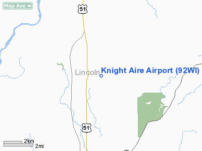
Location & QuickFacts
| FAA Information Effective: | 2008-09-25 |
| Airport Identifier: | 92WI |
| Airport Status: | Operational |
| Longitude/Latitude: | 089-38-28.0000W/45-17-46.0000N
-89.641111/45.296111 (Estimated) |
| Elevation: | 1605 ft / 489.20 m (Estimated) |
| Land: | 17 acres |
| From nearest city: | 7 nautical miles NE of Merrill, WI |
| Location: | Lincoln County, WI |
| Magnetic Variation: | 00E (1985) |
Owner & Manager
| Ownership: | Privately owned |
| Owner: | Burton J. Schnur Iii |
| Address: | N4840 Knight Lake Rd
Merrill, WI 54452 |
| Phone number: | 715-536-8405 |
| Manager: | Burton J. Schnur Iii |
| Address: | N4840 Knight Lake Rd
Merrill, WI 54452 |
| Phone number: | 715-536-8405 |
Airport Operations and Facilities
| Airport Use: | Private |
| Wind indicator: | Yes |
| Segmented Circle: | No |
| Control Tower: | No |
| Sectional chart: | Green Bay |
| Region: | AGL - Great Lakes |
| Boundary ARTCC: | ZMP - Minneapolis |
| Tie-in FSS: | GRB - Green Bay |
| FSS Toll Free: | 1-800-WX-BRIEF |
Runway Information
Runway 01/19
| Dimension: | 2000 x 60 ft / 609.6 x 18.3 m |
| Surface: | TURF, Fair Condition |
| |
Runway 01 |
Runway 19 |
| Traffic Pattern: | Left | Left |
| Displaced threshold: | 0.00 ft | 750.00 ft |
| Obstruction: | , 20:1 slope to clear | 55 ft trees, 1100.0 ft from runway, 20:1 slope to clear |
|
Radio Navigation Aids
| ID |
Type |
Name |
Ch |
Freq |
Var |
Dist |
| RRL | NDB | Merrill | | 257.00 | 01W | 6.4 nm |
| FZK | NDB | Wausau | | 243.00 | 01E | 22.1 nm |
| AIG | NDB | Antigo | | 347.00 | 02W | 23.8 nm |
| MDZ | NDB | Medford | | 335.00 | 00E | 30.5 nm |
| DO | NDB | Dougy | | 236.00 | 01W | 32.6 nm |
| ARV | NDB | Arbor Vitae | | 221.00 | 01W | 38.1 nm |
| PBH | NDB | Phillips | | 263.00 | 00E | 40.7 nm |
| EGV | NDB | Eagle River | | 341.00 | 02W | 41.4 nm |
| MFI | NDB | Marshfield | | 391.00 | 00E | 45.7 nm |
| RHI | VORTAC | Rhinelander | 029X | 109.20 | 02E | 21.7 nm |
| AUW | VORTAC | Wausau | 053X | 111.60 | 02E | 27.1 nm |
| STE | VORTAC | Stevens Point | 043X | 110.60 | 01W | 45.5 nm |
Remarks
- NO SNOW RMVL DURG WINTER MONTHS.
- DEER ON & INVOF ARPT.
- BE ALERT FOR A HILL IN THE MIDDLE OF RY 01/19.
Images and information placed above are from
http://www.airport-data.com/airport/92WI/
We thank them for the data!
| General Info
|
| Country |
United States
|
| State |
WISCONSIN
|
| FAA ID |
92WI
|
| Latitude |
45-17-46.000N
|
| Longitude |
089-38-28.000W
|
| Elevation |
1605 feet
|
| Near City |
MERRILL
|
We don't guarantee the information is fresh and accurate. The data may
be wrong or outdated.
For more up-to-date information please refer to other sources.
|
|


