 |
|
John F Kennedy Memorial Airport |
- For the airport in New York City, see John F. Kennedy International Airport.
| John F. Kennedy Memorial Airport |
| IATA: ASX – ICAO: KASX |
| Summary |
| Airport type |
Public |
| Operator |
City of Ashland |
| Location |
Ashland, Wisconsin |
| Elevation AMSL |
826 ft / 251.8 m |
| Coordinates |
46°32′55″N 90°55′08″W / 46.54861°N 90.91889°W / 46.54861; -90.91889Coordinates: 46°32′55″N 90°55′08″W / 46.54861°N 90.91889°W / 46.54861; -90.91889 |
| Runways |
| Direction |
Length |
Surface |
| ft |
m |
| 2/20 |
5,199 |
1,585 |
Asphalt |
| 13/31 |
3,498 |
1,066 |
Asphalt |
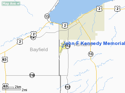
John F. Kennedy Memorial Airport (IATA: ASX, ICAO: KASX), also known as JFK Memorial Airport, is a general aviation airport located 2 miles (3.2 km) southwest of the city Ashland, in Ashland County, Wisconsin, USA. It covers 467 acres (189 ha) and has two runways.
The above content comes from Wikipedia and is published under free licenses – click here to read more.
Location & QuickFacts
| FAA Information Effective: | 2008-09-25 |
| Airport Identifier: | ASX |
| Airport Status: | Operational |
| Longitude/Latitude: | 090-55-08.3000W/46-32-54.7000N
-90.918972/46.548528 (Estimated) |
| Elevation: | 827 ft / 252.07 m (Surveyed) |
| Land: | 511 acres |
| From nearest city: | 2 nautical miles SW of Ashland, WI |
| Location: | Ashland County, WI |
| Magnetic Variation: | 02E (1980) |
Owner & Manager
| Ownership: | Publicly owned |
| Owner: | City Of Ashland |
| Address: |
Ashland, WI 54806 |
| Phone number: | 715-682-7070 |
| Manager: | Robert Hom |
| Address: | 708 Ninth Ave West
Ashland, WI 54806 |
| Phone number: | 715-685-0285 |
Airport Operations and Facilities
| Airport Use: | Open to public |
| Wind indicator: | Yes |
| Segmented Circle: | No |
| Control Tower: | No |
| Lighting Schedule: | DUSK-DAWN
ACTVT MIRLS RY 13/31 02/20, REIL & PAPI RY 02 - CTAF. |
| Beacon Color: | Clear-Green (lighted land airport) |
| Landing fee charge: | No |
| Sectional chart: | Green Bay |
| Region: | AGL - Great Lakes |
| Boundary ARTCC: | ZMP - Minneapolis |
| Tie-in FSS: | GRB - Green Bay |
| FSS on Airport: | No |
| FSS Toll Free: | 1-800-WX-BRIEF |
| NOTAMs Facility: | ASX (NOTAM-d service avaliable) |
| Federal Agreements: | NGY |
Airport Communications
| CTAF: | 122.800 |
| Unicom: | 122.800 |
Airport Services
| Fuel available: | 100LLA A1+
JET A1+ PPR CTC AMGR 715-682-7070, AFT HRS CALL 715-292-7070. 24 HR SELF SERVE 100LL |
| Airframe Repair: | MINOR |
| Power Plant Repair: | MINOR |
| Bottled Oxygen: | NONE |
| Bulk Oxygen: | NONE |
Runway Information
Runway 02/20
| Dimension: | 5197 x 100 ft / 1584.0 x 30.5 m |
| Surface: | ASPH, Good Condition |
| Weight Limit: | Single wheel: 42000 lbs.
Dual wheel: 52000 lbs. |
| Edge Lights: | Medium |
| |
Runway 02 |
Runway 20 |
| Longitude: | 090-55-28.7496W | 090-55-02.3850W |
| Latitude: | 46-32-25.9834N | 46-33-13.9560N |
| Elevation: | 819.00 ft | 823.00 ft |
| Alignment: | 21 | 127 |
| ILS Type: | LOC/DME | |
| Traffic Pattern: | Left | Left |
| Markings: | Non-precision instrument, Fair Condition | Non-precision instrument, Fair Condition |
| Crossing Height: | 41.00 ft | 34.00 ft |
| VASI: | 4-light PAPI on left side | 4-light PAPI on left side |
| Visual Glide Angle: | 3.00° | 3.00° |
| Runway End Identifier: | Yes | No |
| Centerline Lights: | No | No |
| Touchdown Lights: | No | No |
| Obstruction: | 50 ft trees, 2300.0 ft from runway, 300 ft right of centerline, 42:1 slope to clear | 67 ft trees, 2210.0 ft from runway, 30:1 slope to clear |
|
Runway 13/31
| Dimension: | 3498 x 75 ft / 1066.2 x 22.9 m |
| Surface: | ASPH, Good Condition |
| Weight Limit: | Single wheel: 40000 lbs.
Dual wheel: 50000 lbs. |
| Edge Lights: | Medium |
| |
Runway 13 |
Runway 31 |
| Longitude: | 090-55-16.6057W | 090-54-38.5645W |
| Latitude: | 46-33-12.9298N | 46-32-50.4995N |
| Elevation: | 824.00 ft | 810.00 ft |
| Alignment: | 127 | 127 |
| Traffic Pattern: | Left | Left |
| Markings: | Non-precision instrument, Good Condition | Non-precision instrument, Good Condition |
| Crossing Height: | 0.00 ft | 37.00 ft |
| VASI: | | 2-light PAPI on left side |
| Visual Glide Angle: | 0.00° | 3.00° |
| Runway End Identifier: | No | No |
| Centerline Lights: | No | No |
| Touchdown Lights: | No | No |
| Obstruction: | 40 ft trees, 1300.0 ft from runway, 300 ft left of centerline, 27:1 slope to clear | 45 ft trees, 1100.0 ft from runway, 300 ft right of centerline, 20:1 slope to clear |
|
Radio Navigation Aids
| ID |
Type |
Name |
Ch |
Freq |
Var |
Dist |
| ENY | NDB | Kennedy | | 254.00 | 02E | 0.3 nm |
| SLY | NDB | Seeley | | 344.00 | 01E | 32.6 nm |
| OLG | NDB | Solon Springs | | 388.00 | 01E | 39.6 nm |
| PKF | NDB | Park Falls | | 371.00 | 01W | 41.2 nm |
| TWM | NDB | Two Harbors | | 243.00 | 01E | 45.5 nm |
| BFW | NDB | Silver Bay | | 350.00 | 00E | 46.8 nm |
| SUW | NDB | Bong | | 260.00 | 01E | 49.6 nm |
| HYR | VOR/DME | Hayward | 081X | 113.40 | 03E | 38.6 nm |
| IWD | VORTAC | Ironwood | 025X | 108.80 | 01E | 32.8 nm |
Remarks
- ULTRALIGHT ACTVTY ON & INVOF ARPT.
- TERMINAL BLDG OPEN 0600-2000 MAY-OCT & 0800-1600 NOV-APR.
- DEER & OTHER WILDLIFE ON & INVOF ARPT. HEAVY BIRD ACTIVITY SPRINF & SUMMER MONTHS.
- SNOW REMOVAL OPNS WINTER MONTHS.
- ACFT OVER 4000 LBS MUST STOP OR PARK ON CONC IF ABLE.
Images and information placed above are from
http://www.airport-data.com/airport/ASX/
We thank them for the data!
| General Info
|
| Country |
United States
|
| State |
WISCONSIN
|
| FAA ID |
ASX
|
| Latitude |
46-32-54.701N
|
| Longitude |
090-55-08.279W
|
| Elevation |
826 feet
|
| Near City |
ASHLAND
|
We don't guarantee the information is fresh and accurate. The data may
be wrong or outdated.
For more up-to-date information please refer to other sources.
|
|


