 |
|
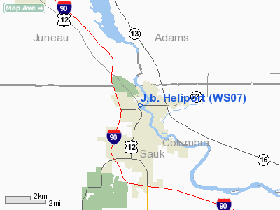
Location & QuickFacts
| FAA Information Effective: | 2008-09-25 |
| Airport Identifier: | WS07 |
| Airport Status: | Operational |
| Longitude/Latitude: | 089-47-06.2490W/43-37-38.0260N
-89.785069/43.627229 (Estimated) |
| Elevation: | 900 ft / 274.32 m (Estimated) |
| Land: | 1 acres |
| From nearest city: | 6 nautical miles N of Wisconsin Dells, WI |
| Location: | Sauk County, WI |
| Magnetic Variation: | 00E (1985) |
Owner & Manager
| Ownership: | Privately owned |
| Owner: | J.b. Helicopters Dba |
| Address: | Po Box 38
Thorndike, MA 01079 |
| Phone number: | 413-283-4534 |
| Manager: | John Boulette |
| Address: | Po Box 38
Thorndike, MA 01079 |
| Phone number: | 413-283-4534 |
Airport Operations and Facilities
| Airport Use: | Private |
| Wind indicator: | Yes |
| Segmented Circle: | No |
| Control Tower: | No |
| Sectional chart: | Chicago |
| Region: | AGL - Great Lakes |
| Boundary ARTCC: | ZAU - Chicago |
| Tie-in FSS: | GRB - Green Bay |
| FSS Toll Free: | 1-800-WX-BRIEF |
Airport Services
Runway Information
Helipad H1
| Dimension: | 160 x 150 ft / 48.8 x 45.7 m |
| Surface: | CONC, |
| |
Runway H1 |
Runway |
| Traffic Pattern: | Left | Left |
|
Radio Navigation Aids
| ID |
Type |
Name |
Ch |
Freq |
Var |
Dist |
| HBW | NDB | Kickapoo | | 251.00 | 03E | 23.9 nm |
| MS | NDB | Monah | | 400.00 | 00E | 39.0 nm |
| CMY | NDB | Mccoy | | 412.00 | 00E | 41.6 nm |
| ISW | NDB | Wisconsin Rapids | | 215.00 | 01W | 44.3 nm |
| MRJ | NDB | Mineral Point | | 365.00 | 00W | 48.5 nm |
| UNU | NDB | Juneau | | 344.00 | 01W | 48.7 nm |
| VOK | TACAN | Volk | 041X | | 00E | 28.0 nm |
| LNR | VOR/DME | Lone Rock | 075X | 112.80 | 00E | 25.1 nm |
| DLL | VORTAC | Dells | 117X | 117.00 | 03E | 4.7 nm |
| MSN | VORTAC | Madison | 023X | 108.60 | 03E | 34.9 nm |
Remarks
- PRVD APCH/DEP RTE HELI OPNS ARE CONDUCTED IN AREA 270-180 DEG USING TD PAD AS CNTR OF A COMPASSROSE; TKOF/LNDG AREA APROPLY MKD; A NON-OBSTNG WIND INDCR MAINTD ADJ TO TKOF/LNDG AREA.
Images and information placed above are from
http://www.airport-data.com/airport/WS07/
We thank them for the data!
| General Info
|
| Country |
United States
|
| State |
WISCONSIN
|
| FAA ID |
WS07
|
| Latitude |
43-37-38.026N
|
| Longitude |
089-47-06.249W
|
| Elevation |
900 feet
|
| Near City |
WISCONSIN DELLS
|
We don't guarantee the information is fresh and accurate. The data may
be wrong or outdated.
For more up-to-date information please refer to other sources.
|
|


