 |
|
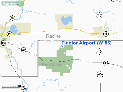
Location & QuickFacts
| FAA Information Effective: | 2008-09-25 |
| Airport Identifier: | WI86 |
| Airport Status: | Operational |
| Longitude/Latitude: | 088-08-09.3120W/42-39-39.0640N
-88.135920/42.660851 (Estimated) |
| Elevation: | 800 ft / 243.84 m (Estimated) |
| Land: | 20 acres |
| From nearest city: | 2 nautical miles SW of Kansasville, WI |
| Location: | Kenosha County, WI |
| Magnetic Variation: | 01W (1990) |
Owner & Manager
| Ownership: | Privately owned |
| Owner: | Kenneth E. Flaglor |
| Address: | 450 264th Ave
Kansasville, WI 53139 |
| Phone number: | 414-878-4527 |
| Manager: | Kenneth E. Flaglor |
| Address: | 450 264th Ave
Kansasville, WI 53139 |
| Phone number: | 414-878-4527 |
Airport Operations and Facilities
| Airport Use: | Private |
| Wind indicator: | Yes |
| Segmented Circle: | No |
| Control Tower: | No |
| Sectional chart: | Chicago |
| Region: | AGL - Great Lakes |
| Boundary ARTCC: | ZAU - Chicago |
| Tie-in FSS: | GRB - Green Bay |
| FSS Toll Free: | 1-800-WX-BRIEF |
Runway Information
Runway 09/27
| Dimension: | 1600 x 50 ft / 487.7 x 15.2 m |
| Surface: | TURF, |
| |
Runway 09 |
Runway 27 |
| Traffic Pattern: | Left | Left |
| Obstruction: | 30 ft pline, 800.0 ft from runway | |
|
Radio Navigation Aids
| ID |
Type |
Name |
Ch |
Freq |
Var |
Dist |
| RA | NDB | Paser | | 206.00 | 00E | 10.5 nm |
| GM | NDB | Teels | | 242.00 | 02W | 15.5 nm |
| LVV | NDB | Lake Lawn | | 404.00 | 00W | 20.3 nm |
| UES | NDB | Waukesha | | 359.00 | 01W | 23.5 nm |
| BL | NDB | Yanks | | 260.00 | 02W | 26.6 nm |
| JVL | NDB | Janesville | | 375.00 | 03E | 40.1 nm |
| RYV | NDB | Rock River | | 371.00 | 01W | 40.3 nm |
| ME | NDB | Deana | | 350.00 | 00E | 41.9 nm |
| HXF | NDB | Hartford | | 200.00 | 00E | 42.9 nm |
| LLE | NDB | Kettle Moraine | | 329.00 | 01W | 45.9 nm |
| BJB | VOR | West Bend | | 109.80 | 01W | 45.8 nm |
| BUU | VOR/DME | Burbun | 092X | 114.50 | 01W | 7.5 nm |
| ENW | VOR/DME | Kenosha | 029X | 109.20 | 02W | 9.8 nm |
| HRK | VOR/DME | Horlick | 124X | 117.70 | 02W | 15.4 nm |
| LJT | VOR/DME | Timmerman | 072X | 112.50 | 02W | 27.3 nm |
| OBK | VOR/DME | Northbrook | 077X | 113.00 | 02W | 27.6 nm |
| ORD | VOR/DME | Chicago O'hare | 086X | 113.90 | 02E | 41.7 nm |
| JVL | VOR/DME | Janesville | 090X | 114.30 | 03E | 43.3 nm |
| DPA | VOR/DME | Dupage | 021X | 108.40 | 02E | 47.3 nm |
| BAE | VORTAC | Badger | 111X | 116.40 | 02E | 28.2 nm |
| MKE | VOT | Milwaukee | | 109.00 | | 20.2 nm |
| ORD | VOT | Chicago O'hare Intl | | 112.00 | | 42.0 nm |
Remarks
- OWNER DESIRES ARPT NOT BE CHARTED.
- PRVDD THE FUTURE HOUSE NOT BE BUILT; OBSTNS IN RY APCH SFCS LWRD/REMOVED OR RY THRS DSPLCED & MKD TO PRVD MIN 20:1 APCH CLNC OVER OBST.
Images and information placed above are from
http://www.airport-data.com/airport/WI86/
We thank them for the data!
| General Info
|
| Country |
United States
|
| State |
WISCONSIN
|
| FAA ID |
WI86
|
| Latitude |
42-39-39.064N
|
| Longitude |
088-08-09.312W
|
| Elevation |
800 feet
|
| Near City |
KANSASVILLE
|
We don't guarantee the information is fresh and accurate. The data may
be wrong or outdated.
For more up-to-date information please refer to other sources.
|
|


