 |
|
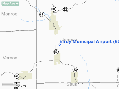
Location & QuickFacts
| FAA Information Effective: | 2008-09-25 |
| Airport Identifier: | 60C |
| Airport Status: | Operational |
| Longitude/Latitude: | 090-15-27.4620W/43-42-22.9010N
-90.257628/43.706361 (Estimated) |
| Elevation: | 944 ft / 287.73 m (Surveyed) |
| Land: | 18 acres |
| From nearest city: | 2 nautical miles S of Elroy, WI |
| Location: | Juneau County, WI |
| Magnetic Variation: | 01E (1985) |
Owner & Manager
| Ownership: | Privately owned |
| Owner: | Elroy Airport Inc. |
| Address: | N1862 Hwy 80
Elroy, WI 53929 |
| Phone number: | 608-462-5200 |
| Manager: | Mike Erickson |
| Address: | Box 74
Elroy, WI 53929 |
| Phone number: | 608-462-5798 |
Airport Operations and Facilities
| Airport Use: | Open to public |
| Wind indicator: | No |
| Segmented Circle: | Yes |
| Control Tower: | No |
| Lighting Schedule: | DUSK-DAWN |
| Landing fee charge: | No |
| Sectional chart: | Chicago |
| Region: | AGL - Great Lakes |
| Traffic Pattern Alt: | 800 ft |
| Boundary ARTCC: | ZAU - Chicago |
| Tie-in FSS: | GRB - Green Bay |
| FSS on Airport: | No |
| FSS Toll Free: | 1-800-WX-BRIEF |
| NOTAMs Facility: | GRB (NOTAM-d service avaliable) |
Airport Communications
Airport Services
| Airframe Repair: | NONE |
| Power Plant Repair: | NONE |
| Bottled Oxygen: | NONE |
| Bulk Oxygen: | NONE |
Runway Information
Runway 06/24
| Dimension: | 3085 x 100 ft / 940.3 x 30.5 m |
| Surface: | GRVL-TURF, Poor Condition
2550 FT BY 34 FT GRVL SUPERIMPOSED ON TURF RY; SFC PATCHY & ROUGH. |
| Edge Lights: | Non-standard lighting system
NSTD LIRL THLD LGTS, ALL GREEN LENSES. |
| |
Runway 06 |
Runway 24 |
| Longitude: | 090-15-45.3700W | 090-15-09.5500W |
| Latitude: | 43-42-14.9400N | 43-42-30.8600N |
| Elevation: | 944.00 ft | 944.00 ft |
| Traffic Pattern: | Left | Right |
| Markings: | None, | None, |
| Obstruction: | 39 ft trees, 680.0 ft from runway, 50 ft left of centerline, 17:1 slope to clear | 40 ft tree, 0.0 ft from runway, 50 ft right of centerline |
|
Radio Navigation Aids
| ID |
Type |
Name |
Ch |
Freq |
Var |
Dist |
| HBW | NDB | Kickapoo | | 251.00 | 03E | 4.5 nm |
| CMY | NDB | Mccoy | | 412.00 | 00E | 21.7 nm |
| BCK | NDB | Black River Falls | | 362.00 | 00E | 41.7 nm |
| ISW | NDB | Wisconsin Rapids | | 215.00 | 01W | 43.5 nm |
| MRJ | NDB | Mineral Point | | 365.00 | 00W | 49.2 nm |
| VOK | TACAN | Volk | 041X | | 00E | 14.2 nm |
| LNR | VOR/DME | Lone Rock | 075X | 112.80 | 00E | 25.4 nm |
| LSE | VOR/DME | La Crosse | 021X | 108.40 | 02E | 44.5 nm |
| DLL | VORTAC | Dells | 117X | 117.00 | 03E | 23.4 nm |
Remarks
- TALL BLUFFS & TREES LCTD ON BOTH SIDES OF RWY.
Images and information placed above are from
http://www.airport-data.com/airport/60C/
We thank them for the data!
| General Info
|
| Country |
United States
|
| State |
WISCONSIN
|
| FAA ID |
60C
|
| Latitude |
43-42-22.901N
|
| Longitude |
090-15-27.462W
|
| Elevation |
944 feet
|
| Near City |
ELROY
|
We don't guarantee the information is fresh and accurate. The data may
be wrong or outdated.
For more up-to-date information please refer to other sources.
|
|


