 |
|
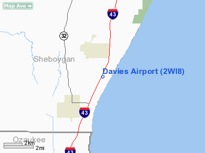
Location & QuickFacts
| FAA Information Effective: | 2008-09-25 |
| Airport Identifier: | 2WI8 |
| Airport Status: | Operational |
| Longitude/Latitude: | 087-46-44.3150W/43-35-50.9900N
-87.778976/43.597497 (Estimated) |
| Elevation: | 645 ft / 196.60 m (Estimated) |
| Land: | 0 acres |
| From nearest city: | 2 nautical miles SE of Oostburg, WI |
| Location: | Sheboygan County, WI |
| Magnetic Variation: | 02W (1990) |
Owner & Manager
| Ownership: | Privately owned |
| Owner: | Lincoln J Davies |
| Address: | W1639 De Witt Rd
Oostburg, WI 53070 |
| Phone number: | 414-564-2277 |
| Address: |
|
Airport Operations and Facilities
| Airport Use: | Private |
| Segmented Circle: | No |
| Control Tower: | No |
| Sectional chart: | Chicago |
| Region: | AGL - Great Lakes |
| Boundary ARTCC: | ZAU - Chicago |
| Tie-in FSS: | GRB - Green Bay |
| FSS Toll Free: | 1-800-WX-BRIEF |
Runway Information
Runway 15/33
| Dimension: | 2500 x 80 ft / 762.0 x 24.4 m |
| Surface: | TURF, |
| |
Runway 15 |
Runway 33 |
| Traffic Pattern: | Left | Right |
| Obstruction: | 25 ft pline | |
|
Radio Navigation Aids
| ID |
Type |
Name |
Ch |
Freq |
Var |
Dist |
| LLE | NDB | Kettle Moraine | | 329.00 | 01W | 18.4 nm |
| HXF | NDB | Hartford | | 200.00 | 00E | 30.8 nm |
| BL | NDB | Yanks | | 260.00 | 02W | 32.6 nm |
| UES | NDB | Waukesha | | 359.00 | 01W | 38.8 nm |
| UNU | NDB | Juneau | | 344.00 | 01W | 41.5 nm |
| GM | NDB | Teels | | 242.00 | 02W | 42.9 nm |
| AQ | NDB | Kooky | | 407.00 | 02W | 45.9 nm |
| RYV | NDB | Rock River | | 371.00 | 01W | 48.6 nm |
| BJB | VOR | West Bend | | 109.80 | 01W | 18.4 nm |
| FAH | VOR/DME | Falls | 37X | 110.00 | 02W | 10.7 nm |
| LJT | VOR/DME | Timmerman | 072X | 112.50 | 02W | 31.4 nm |
| MTW | VOR/DME | Manitowoc | 047X | 111.00 | 02W | 32.2 nm |
| BAE | VORTAC | Badger | 111X | 116.40 | 02E | 36.4 nm |
| OSH | VORTAC | Oshkosh | 055X | 111.80 | 02E | 41.2 nm |
| MKE | VOT | Milwaukee | | 109.00 | | 39.4 nm |
Remarks
- OBS REMOVED/LOWERED OR THRS DSPLCD TO PRVD 20:1 SLOPES; 125' EITHER SIDE OF CNTRLN & 200' EITHER END BE CLEAR OF OBS.
Images and information placed above are from
http://www.airport-data.com/airport/2WI8/
We thank them for the data!
| General Info
|
| Country |
United States
|
| State |
WISCONSIN
|
| FAA ID |
2WI8
|
| Latitude |
43-35-50.990N
|
| Longitude |
087-46-44.315W
|
| Elevation |
645 feet
|
| Near City |
OOSTBURG
|
We don't guarantee the information is fresh and accurate. The data may
be wrong or outdated.
For more up-to-date information please refer to other sources.
|
|


