|
 |
|
||||
|
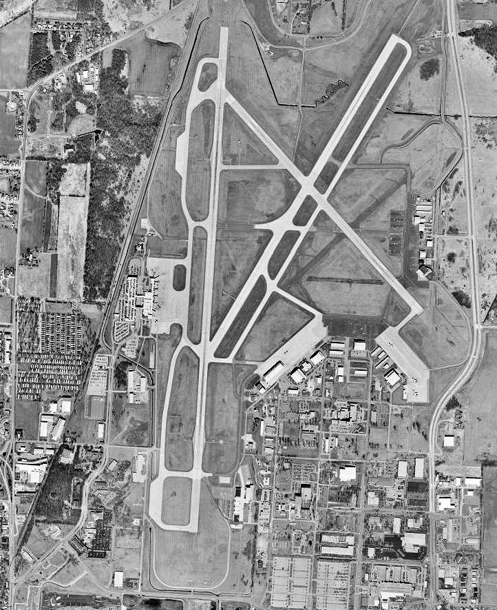
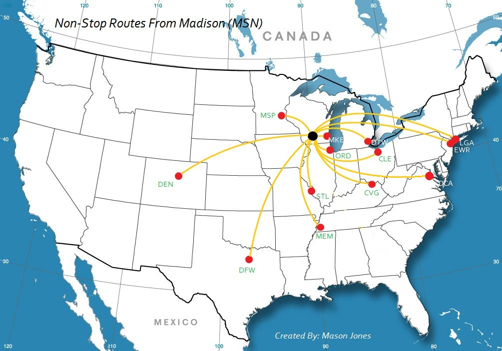
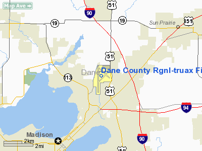
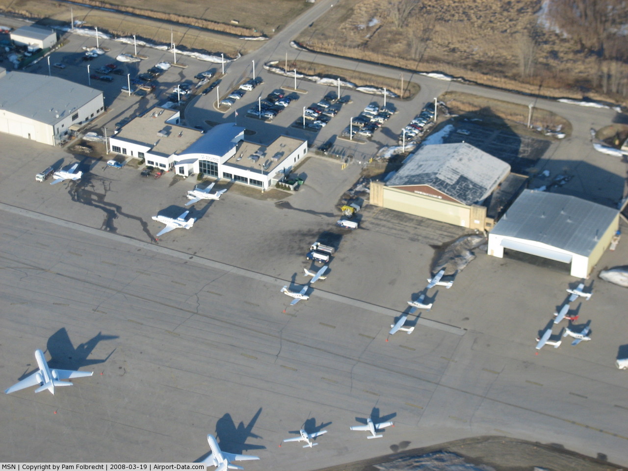
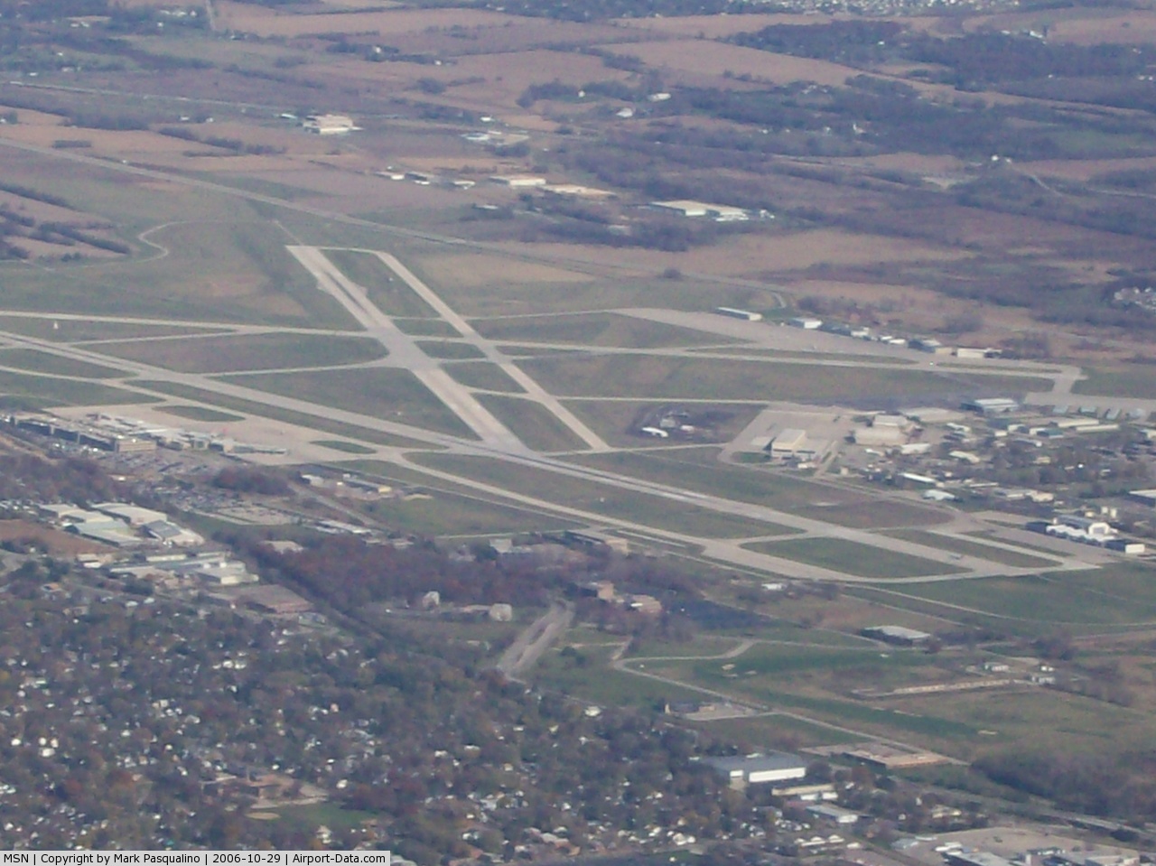
Dane County Regional Airport (IATA: MSN, ICAO: KMSN, FAA LID: MSN), also known as Truax Field, is a joint civil-military commercial airport located five nautical miles (9 km) northeast of the central business district of Madison, a city in Dane County, Wisconsin, United States. It has three runways and in 2006 it served over 1.6 million passengers. MSN serves Continental, Frontier, United, American, Midwest, US Airways and Delta airlines with Delta being the largest carrier with the most direct flights. These airlines offer non-stop service to major hubs through out the Midwest, East Coast and South as well as destinations such as Atlanta, Washington DC, New York City, Memphis, New Jersey and Denver. Truax Field was named in honor of Wisconsin-native Lieutenant Thomas L. Truax, killed, along with his wingman, Lt. Speckman, in a P-40 training accident during poor weather in San Anselmo, CA on November 2, 1941, just before war was declared. The airport is home to both the Wisconsin Army National Guard and the Wisconsin Air National Guard. HistoryOriginally known as Madison Army Airfield, Truax Field was activated as an Army Air Forces airfield in June 1942 during World War II. During the war it was used by the Army Air Force Eastern Technical Training Center, a major school operating at Truax AAF for training radio operators and mechanics, and later expanded to training in radar operations, control tower operations and other communications fields for the Army Airways Communication Service. A special unit established in 1943 trained radio operators and mechanics on B-29 Superfortress communications equipment. The host unit on the airfield was the 334th (later 3508th) Army Air Force Base Unit. On September 17, 1945, the airfield's mission was changed to that of a separation center, and it was closed as an active AAF airfield on November 30, 1945. Conveyed to local civilian authorities, the Madison Municipal Airport also became the home of the Wisconsin Air National Guard and its present day 115th Fighter Wing (115 FW), an Air National Guard fighter wing operationally-gained by the Air Combat Command (ACC) and which still operates from the base, flying the F-16 Fighting Falcon. Reactivated by the United States Air Force on February 1, 1952 and renamed Truax Air Force Base, the installation was brought up to active duty status during the Korean War as an Air Defense Command (ADC) fighter-interceptor base. The initial USAF unit assigned to Truax was the 78th Air Base Squadron. ADC assigned Truax AFB to its Central Air Defense Force and activated the Wisconsin Air National Guard's 128th Fighter-Interceptor Group, normally based in Milwaukee. The 128th FIG flew F-80 Shooting Stars from Truax until returning to Milwaukee in February 1952. After some construction of additional runways, taxiways, aprons and support facilities, the 78th Fighter-Interceptor Group with its 432d and 433d Fighter-Interceptor Squadrons arrived on November 1, 1952, replacing the 78th ABS as the host operating unit at Truax. The 78th was reassigned from Hamilton AFB, California and flew the F-86 Sabre and F-89 Scorpion aircraft in a fighter-interceptor role. On April 9, 1955, Truax AFB became the headquarters of ADC' 37th Air Division (Defense). The 37th AD was responsible for the air defense of parts of Wisconsin, Illinois, and Indiana, including Chicago. On April 1, 1959, ADC's 30th Air Division (SAGE) replaced the 37th AD. The 30th was a command and control organization responsible for radar coverage of the midwest using the Semi Automatic Ground Environment (SAGE) automated control system for tracking and intercepting enemy bomber aircraft. SAGE, in later versions, could also automatically direct aircraft to an interception by sending commands directly to the aircraft's autopilot. In the late 1950s, the aircraft assigned to the base changed to the F-102 Delta Dagger and the 78th was replaced by the 327th Fighter-Interceptor Group, which arrived in 1956, replacing the 78th. The 327th's squadrons were the 61st, 323d and 325th Fighter-Interceptor Squadrons. In 1966, Headquarters, 30th Air Division, was reassigned to Sioux City Municipal Airport, Iowa, and the 20th Air Division replaced it at Truax. The 20th AD was responsible for air defense of parts of Wisconsin, Minnesota, Iowa, Missouri, Arkansas, Tennessee, Kentucky, Indiana, and all of Illinois. It also supervised Air National Guard units that flew interception sorties using, among others, the F-101 Voodoo and F-106 Delta Dart aircraft, while at the same time controlling numerous ground=based USAF radar squadrons. By the late 1960s, the need for air defense against manned aircraft was diminishing and the renamed Aerospace Defense Command (ADC) was consolidating and drawing down its forces. On December 31, 1967, the 20th AD was reassigned to Fort Lee AFS, Virginia and Truax AFB was deactivated as an active Aerospace Defense Command base in early 1968. Those portions of Truax AFB not reverting to civilian control were turned over to the Wisconsin Air National Guard as Truax Field Air National Guard Base and Dane County Regional Airport/Truax Field has been a joint military/civil airport ever since. Today, Truax Field ANGB remains the home installation of the 115th Fighter Wing (115 FW), an Air National Guard unit operationally gained by the Air Combat Command (ACC), flying the F-16C/D Fighting Falcon multi-role fighter aircraft. The 115 FW has two distinct missions. The Federal mission under Title 10 USC is to staff and train flying and support units to augment Air Combat Command general purpose fighter forces to effectively and rapidly project F-16 combat power anywhere in the world to perform wartime or peacetime missions as well as operations other than war. The 115 FW maintains mobilization readiness as part of the Air Reserve Component (ARC) and conducts training in support of Total Force capabilities as directed by the gaining command (i.e., ACC). The State mission under Title 32 USC is to provide trained and equipped units to protect life and property and to preserve peace, order, and public safety as directed by the Governor of Wisconsin. In 2006 the airport completed a $65 million expansion that doubled the size of the terminal, built in a Frank Lloyd Wright-influenced prairie style. New features include more restaurant and retail area post-security, an art court, and both business and family lounges. As has been the case in the past decade the airport has once again been adding additional parking since 2007. Facilities and aircraftDane County Regional Airport covers an area of 3,500 acres (1,416 ha) at an elevation of 887 feet (270 m) above mean sea level. It has three runways with concrete surfaces: 3/21 is 7,200 by 150 feet (2,195 x 46 m); 14/32 is 5,846 by 150 feet (1,782 x 46 m); 18/36 is 9,006 by 150 feet (2,745 x 46 m). The fixed base operator (FBO) is Wisconsin Aviation, which purchased the assets of the former FBO, Four Lakes Aviation, in 1994. For the 12-month period ending December 31, 2006, the airport had 115,613 aircraft operations, an average of 316 per day: 59% general aviation, 24% air taxi, 10% scheduled commercial and 7% military. At that time there were 257 aircraft based at this airport: 54% single-engine, 24% multi-engine, 8% jet, 6% helicopter and 7% military. Airlines and destinations
The above content comes from Wikipedia and is published under free licenses – click here to read more.
Location & QuickFacts
Owner & Manager
Airport Operations and Facilities
Airport Communications
Airport Services
Runway InformationRunway 03/21
Runway 14/32
Runway 18/36
Radio Navigation Aids
Remarks
Images and information placed above are from We thank them for the data!
We don't guarantee the information is fresh and accurate. The data may
be wrong or outdated.
|
|||||||||||||||||||||||||||||||||||||||||||||||||||||||||||||||||||||||||||||||||||||||||||||||||||||||||||||||||||||||||||||||||||||||||||||||||||||||||||||||||||||||||||||||||||||||||||||||||||||||||||||||||||||||||||||||||||||||||||||||||||||||||||||||||||||||||||||||||||||||||||||||||||||||||||||||||||||||||||||||||||||||||||||||||||||||||||||||||||||||||||||||||||||||||||||||||||||||||||||||||||||||||||||||||||||||||||||||||||||||||||||||||||||||||||||||||||||||||||||||||||||||||||||||||||||||||||||||||||||||||||||||||||||||||||||

 |
|
Copyright 2004-2026 © by Airports-Worldwide.com, Vyshenskoho st. 36, Lviv 79010, Ukraine Legal Disclaimer |