 |
|
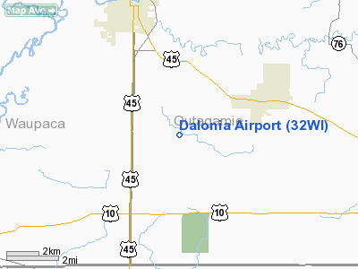
Location & QuickFacts
| FAA Information Effective: | 2008-09-25 |
| Airport Identifier: | 32WI |
| Airport Status: | Operational |
| Longitude/Latitude: | 088-42-03.3850W/44-18-58.9330N
-88.700940/44.316370 (Estimated) |
| Elevation: | 850 ft / 259.08 m (Estimated) |
| Land: | 6 acres |
| From nearest city: | 3 nautical miles NW of Hortonville, WI |
| Location: | Outagamie County, WI |
| Magnetic Variation: | 01W (1990) |
Owner & Manager
| Ownership: | Privately owned |
| Owner: | Robert T. Oudenhoyen |
| Address: | W10110 Ridge Rd
Hortonville, WI 54944 |
| Phone number: | 414-779-6083 |
| Manager: | Robert T. Oudenhoyen |
| Address: | W10110 Ridge Rd
Hortonville, WI 54944 |
| Phone number: | 414-779-6083 |
Airport Operations and Facilities
| Airport Use: | Private |
| Segmented Circle: | No |
| Control Tower: | No |
| Sectional chart: | Green Bay |
| Region: | AGL - Great Lakes |
| Boundary ARTCC: | ZMP - Minneapolis |
| Tie-in FSS: | GRB - Green Bay |
| FSS Toll Free: | 1-800-WX-BRIEF |
Runway Information
Runway 09/27
| Dimension: | 2050 x 50 ft / 624.8 x 15.2 m |
| Surface: | TURF, |
| |
Runway 09 |
Runway 27 |
| Traffic Pattern: | Left | Left |
| Obstruction: | | 15 ft road, 340.0 ft from runway |
|
Radio Navigation Aids
| ID |
Type |
Name |
Ch |
Freq |
Var |
Dist |
| PCZ | NDB | Waupaca | | 382.00 | 01W | 13.6 nm |
| AQ | NDB | Kooky | | 407.00 | 02W | 14.3 nm |
| CLI | NDB | Clintonville | | 209.00 | 02W | 18.2 nm |
| SG | NDB | Depre | | 332.00 | 02W | 24.9 nm |
| OCQ | NDB | Oconto | | 388.00 | 03W | 47.6 nm |
| ISW | NDB | Wisconsin Rapids | | 215.00 | 01W | 49.0 nm |
| MTW | VOR/DME | Manitowoc | 047X | 111.00 | 02W | 45.4 nm |
| FAH | VOR/DME | Falls | 37X | 110.00 | 02W | 49.4 nm |
| OSH | VORTAC | Oshkosh | 055X | 111.80 | 02E | 20.6 nm |
| GRB | VORTAC | Green Bay | 102X | 115.50 | 01E | 26.0 nm |
| STE | VORTAC | Stevens Point | 043X | 110.60 | 01W | 38.1 nm |
| AUW | VORTAC | Wausau | 053X | 111.60 | 02E | 49.5 nm |
Remarks
- RY 09/27 NOT MKD YEAR AROUND DUE TO WINTER MAINTENANCE OR GROUNDS KEEPING.
- PRVDD OBSTN IN RY APCH SLOPE SFC LOWERED/REMOVED OR RY THR DSPLCD TO PRVDD MIN 20:1 APCH CLNC OVER OBSTN; AREA 125 FT EITHER SIDE OF RY CLNC CLEAR OF OBSTN.
Images and information placed above are from
http://www.airport-data.com/airport/32WI/
We thank them for the data!
| General Info
|
| Country |
United States
|
| State |
WISCONSIN
|
| FAA ID |
32WI
|
| Latitude |
44-18-58.933N
|
| Longitude |
088-42-03.385W
|
| Elevation |
850 feet
|
| Near City |
HORTONVILLE
|
We don't guarantee the information is fresh and accurate. The data may
be wrong or outdated.
For more up-to-date information please refer to other sources.
|
|


