 |
|
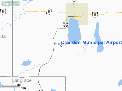
Location & QuickFacts
| FAA Information Effective: | 2008-09-25 |
| Airport Identifier: | Y55 |
| Airport Status: | Operational |
| Longitude/Latitude: | 088-56-00.4090W/45-30-59.8670N
-88.933447/45.516630 (Estimated) |
| Elevation: | 1646 ft / 501.70 m (Estimated) |
| Land: | 259 acres |
| From nearest city: | 3 nautical miles SW of Crandon, WI |
| Location: | Forest County, WI |
| Magnetic Variation: | 01W (1985) |
Owner & Manager
| Ownership: | Publicly owned |
| Owner: | City Of Crandon |
| Address: | 211 East Madison
Crandon, WI 54520 |
| Phone number: | 715-478-2400 |
| Manager: | Norman Knoll |
| Address: | 8765 Mary St
Argonne, WI 54511 |
| Phone number: | 715-649-3225 |
Airport Operations and Facilities
| Airport Use: | Open to public |
| Wind indicator: | Yes |
| Segmented Circle: | No |
| Control Tower: | No |
| Lighting Schedule: | DUSK-DAWN
LIRL RY 11/29 PRESET ON LOW INTST; TO INCR INTST - CTAF. |
| Beacon Color: | Clear-Green (lighted land airport) |
| Landing fee charge: | No |
| Sectional chart: | Green Bay |
| Region: | AGL - Great Lakes |
| Boundary ARTCC: | ZMP - Minneapolis |
| Tie-in FSS: | GRB - Green Bay |
| FSS on Airport: | No |
| FSS Toll Free: | 1-800-WX-BRIEF |
| NOTAMs Facility: | GRB (NOTAM-d service avaliable) |
| Federal Agreements: | NGY |
Airport Communications
Airport Services
| Airframe Repair: | NONE |
| Power Plant Repair: | NONE |
| Bottled Oxygen: | NONE |
| Bulk Oxygen: | NONE |
Runway Information
Runway 01/19
| Dimension: | 2730 x 100 ft / 832.1 x 30.5 m
80 FT STWY S END; 250 FT STWY N END. |
| Surface: | TURF, Fair Condition |
| |
Runway 01 |
Runway 19 |
| Longitude: | 088-55-32.3700W | 088-55-28.4500W |
| Latitude: | 45-31-05.1100N | 45-31-31.6300N |
| Elevation: | 1615.00 ft | 1628.00 ft |
| Traffic Pattern: | Left | Left |
| Runway End Identifier: | No | No |
| Centerline Lights: | No | No |
| Touchdown Lights: | No | No |
| Obstruction: | 15 ft road, 700.0 ft from runway, 46:1 slope to clear | 44 ft trees, 1150.0 ft from runway, 150 ft left of centerline, 26:1 slope to clear |
|
Runway 11/29
| Dimension: | 3100 x 75 ft / 944.9 x 22.9 m
80 FT STWY S END; 250 FT STWY N END. |
| Surface: | ASPH, Fair Condition |
| Weight Limit: | Single wheel: 12000 lbs. |
| Edge Lights: | Low |
| |
Runway 11 |
Runway 29 |
| Longitude: | 088-56-08.4300W | 088-55-28.3900W |
| Latitude: | 45-31-30.8800N | 45-31-18.8600N |
| Elevation: | 1646.00 ft | 1625.00 ft |
| Traffic Pattern: | Left | Left |
| Markings: | Non-precision instrument, Fair Condition | Non-precision instrument, Fair Condition |
| Runway End Identifier: | No | No |
| Centerline Lights: | No | No |
| Touchdown Lights: | No | No |
| Obstruction: | 45 ft trees, 1100.0 ft from runway, 150 ft right of centerline, 20:1 slope to clear | 10 ft road, 440.0 ft from runway, 150 ft right of centerline, 24:1 slope to clear |
|
Radio Navigation Aids
| ID |
Type |
Name |
Ch |
Freq |
Var |
Dist |
| AIG | NDB | Antigo | | 347.00 | 02W | 22.8 nm |
| EGV | NDB | Eagle River | | 341.00 | 02W | 28.6 nm |
| RRL | NDB | Merrill | | 257.00 | 01W | 37.8 nm |
| DO | NDB | Dougy | | 236.00 | 01W | 38.5 nm |
| LNL | NDB | Land O Lakes | | 396.00 | 02W | 39.8 nm |
| ARV | NDB | Arbor Vitae | | 221.00 | 01W | 41.5 nm |
| FZK | NDB | Wausau | | 243.00 | 01E | 45.9 nm |
| BDJ | NDB | Boulder Junction | | 206.00 | 02E | 47.9 nm |
| RXW | NDB | Watersmeet | | 407.00 | 01E | 48.6 nm |
| IMT | VOR/DME | Iron Mountain | 049X | 111.20 | 02W | 38.9 nm |
| RHI | VORTAC | Rhinelander | 029X | 109.20 | 02E | 23.2 nm |
| AUW | VORTAC | Wausau | 053X | 111.60 | 02E | 48.9 nm |
Remarks
- OCNL DEER ON & INVOF ARPT.
Images and information placed above are from
http://www.airport-data.com/airport/Y55/
We thank them for the data!
| General Info
|
| Country |
United States
|
| State |
WISCONSIN
|
| FAA ID |
Y55
|
| Latitude |
45-30-59.867N
|
| Longitude |
088-56-00.409W
|
| Elevation |
1646 feet
|
| Near City |
CRANDON
|
We don't guarantee the information is fresh and accurate. The data may
be wrong or outdated.
For more up-to-date information please refer to other sources.
|
|


