 |
|
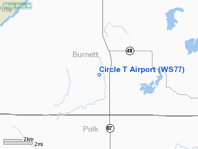
Location & QuickFacts
| FAA Information Effective: | 2008-09-25 |
| Airport Identifier: | WS77 |
| Airport Status: | Operational |
| Longitude/Latitude: | 092-41-13.7000W/45-41-02.5200N
-92.687139/45.684033 (Estimated) |
| Elevation: | 895 ft / 272.80 m (Estimated) |
| Land: | 200 acres |
| From nearest city: | 7 nautical miles S of Grantsburg, WI |
| Location: | Burnett County, WI |
| Magnetic Variation: | 01E (2000) |
Owner & Manager
| Ownership: | Privately owned |
| Owner: | Arlen Bylander |
| Address: | 13687 County Road O
Grantsburg, WI 54840 |
| Phone number: | 651-257-2035 |
| Manager: | Arlen Bylander |
| Address: | 13687 County Road O
Grantsburg, WI 54840 |
| Phone number: | 651-257-2035 |
Airport Operations and Facilities
| Airport Use: | Private |
| Wind indicator: | Yes |
| Segmented Circle: | No |
| Control Tower: | No |
| Sectional chart: | Green Bay |
| Region: | AGL - Great Lakes |
| Boundary ARTCC: | ZMP - Minneapolis |
| Tie-in FSS: | GRB - Green Bay |
| FSS Toll Free: | 1-800-WX-BRIEF |
Runway Information
Runway 09/27
| Dimension: | 2215 x 96 ft / 675.1 x 29.3 m |
| Surface: | TURF, |
| |
Runway 09 |
Runway 27 |
| Traffic Pattern: | Left | Left |
|
Radio Navigation Aids
| ID |
Type |
Name |
Ch |
Freq |
Var |
Dist |
| ROS | NDB | Rush City | | 282.00 | 02E | 11.3 nm |
| BXR | NDB | Big Doctor | | 203.00 | 02E | 15.8 nm |
| OEO | NDB | Osceola | | 233.00 | 01E | 22.5 nm |
| CBG | NDB | Cambridge | | 350.00 | 03E | 25.3 nm |
| JMR | NDB | Mora | | 327.00 | 03E | 27.3 nm |
| AHH | NDB | Ameron | | 278.00 | 01E | 27.6 nm |
| UBE | NDB | Cumberland | | 375.00 | 01E | 31.7 nm |
| SSQ | NDB | Shell Lake | | 212.00 | 01E | 32.3 nm |
| RNH | NDB | New Richmond | | 257.00 | 02E | 32.9 nm |
| PNM | NDB | Princeton | | 368.00 | 03E | 39.4 nm |
| MZH | NDB | Moose Lake | | 362.00 | 02E | 44.3 nm |
| PPI | NDB | Hopey | | 400.00 | 03E | 49.9 nm |
| RZN | VOR/DME | Siren | 031X | 109.40 | 02E | 15.5 nm |
| RPD | VOR/DME | Rice Lake | 037X | 110.00 | 01E | 41.5 nm |
| GEP | VORTAC | Gopher | 120X | 117.30 | 06E | 43.4 nm |
| STP | VOT | St Paul | | 114.40 | | 47.4 nm |
Remarks
- PRVDD OBST IN RY APCH SFC BE LOWERED OR REMOVED OR RELOCATE THLDS TO PROVIDE 20:1 SLOPE, AREA 125 FT EITHER SIDE RY + 200 FT OFF RY ENDS CLEAR OF OBST, AREA 60 FT EITHER SIDE RY CNTRLN + 240 FT OFF RY ENDS IS CLEAR + GRADED.
Images and information placed above are from
http://www.airport-data.com/airport/WS77/
We thank them for the data!
|
|


