 |
|
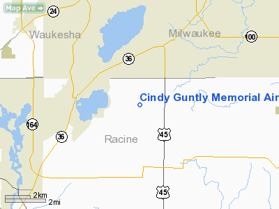
Cindy Guntly Memorial Airport |
Location & QuickFacts
| FAA Information Effective: | 2008-09-25 |
| Airport Identifier: | 62C |
| Airport Status: | Operational |
| Longitude/Latitude: | 088-05-40.3120W/42-49-25.0590N
-88.094531/42.823628 (Estimated) |
| Elevation: | 790 ft / 240.79 m (Estimated) |
| Land: | 15 acres |
| From nearest city: | 7 nautical miles NW of Franksville, WI |
| Location: | Racine County, WI |
| Magnetic Variation: | 01W (1985) |
Owner & Manager
| Ownership: | Privately owned |
| Owner: | Thomas Guntly |
| Address: | 22031 Six Mile Rd
Franksville, WI 53126 |
| Phone number: | 262-895-2948 |
| Manager: | Thomas Guntly |
| Address: | 13620 Bell Road
Caledonia, WI 53108 |
| Phone number: | 262-895-2948 |
Airport Operations and Facilities
| Airport Use: | Open to public |
| Wind indicator: | Yes |
| Segmented Circle: | No |
| Control Tower: | No |
| Lighting Schedule: | RDO-CTL
ACTVT LIRL RY 01/19 - CTAF. |
| Landing fee charge: | No |
| Sectional chart: | Chicago |
| Region: | AGL - Great Lakes |
| Traffic Pattern Alt: | 1000 ft |
| Boundary ARTCC: | ZAU - Chicago |
| Tie-in FSS: | GRB - Green Bay |
| FSS on Airport: | No |
| FSS Toll Free: | 1-800-WX-BRIEF |
| NOTAMs Facility: | GRB (NOTAM-d service avaliable) |
Airport Communications
Airport Services
| Fuel available: | 100LLMOGAS |
| Airframe Repair: | MAJOR |
| Power Plant Repair: | MAJOR |
| Bottled Oxygen: | NONE |
| Bulk Oxygen: | NONE |
Runway Information
Runway 01/19
| Dimension: | 2425 x 70 ft / 739.1 x 21.3 m |
| Surface: | TURF, Fair Condition
ROUGH & UNDULATING ROLLING TERRAIN. |
| Edge Lights: | Non-standard lighting system
RWY 01/19 NSTD LIRL HAS 2 PAIRS OF LGTS EACH END. |
| |
Runway 01 |
Runway 19 |
| Longitude: | 088-05-46.3100W | 088-05-36.3100W |
| Latitude: | 42-49-15.0500N | 42-49-37.0500N |
| Elevation: | 790.00 ft | 790.00 ft |
| Traffic Pattern: | Left | Left |
| Obstruction: | 45 ft tree, 90.0 ft from runway, 100 ft left of centerline, 2:1 slope to clear | 25 ft tree, 0.0 ft from runway, 100 ft right of centerline |
|
Runway 18/36
| Dimension: | 1200 x 80 ft / 365.8 x 24.4 m |
| Surface: | TURF, Fair Condition
ROUGH & UNDULATING ROLLING TERRAIN. |
| |
Runway 18 |
Runway 36 |
| Longitude: | 088-05-36.3100W | 088-05-36.3100W |
| Latitude: | 42-49-43.9900N | 42-49-32.1300N |
| Elevation: | 790.00 ft | 790.00 ft |
| Traffic Pattern: | Left | Left |
| Obstruction: | 45 ft trees, 900.0 ft from runway, 150 ft right of centerline, 20:1 slope to clear | 50 ft tree, 600.0 ft from runway, 150 ft right of centerline, 12:1 slope to clear |
|
Radio Navigation Aids
| ID |
Type |
Name |
Ch |
Freq |
Var |
Dist |
| GM | NDB | Teels | | 242.00 | 02W | 5.7 nm |
| RA | NDB | Paser | | 206.00 | 00E | 12.1 nm |
| UES | NDB | Waukesha | | 359.00 | 01W | 14.7 nm |
| BL | NDB | Yanks | | 260.00 | 02W | 17.1 nm |
| LVV | NDB | Lake Lawn | | 404.00 | 00W | 23.2 nm |
| HXF | NDB | Hartford | | 200.00 | 00E | 34.2 nm |
| RYV | NDB | Rock River | | 371.00 | 01W | 34.8 nm |
| LLE | NDB | Kettle Moraine | | 329.00 | 01W | 36.2 nm |
| JVL | NDB | Janesville | | 375.00 | 03E | 43.6 nm |
| UNU | NDB | Juneau | | 344.00 | 01W | 45.1 nm |
| BJB | VOR | West Bend | | 109.80 | 01W | 36.0 nm |
| BUU | VOR/DME | Burbun | 092X | 114.50 | 01W | 12.2 nm |
| HRK | VOR/DME | Horlick | 124X | 117.70 | 02W | 12.9 nm |
| ENW | VOR/DME | Kenosha | 029X | 109.20 | 02W | 15.3 nm |
| LJT | VOR/DME | Timmerman | 072X | 112.50 | 02W | 17.4 nm |
| OBK | VOR/DME | Northbrook | 077X | 113.00 | 02W | 36.7 nm |
| JVL | VOR/DME | Janesville | 090X | 114.30 | 03E | 47.4 nm |
| BAE | VORTAC | Badger | 111X | 116.40 | 02E | 19.5 nm |
| MKE | VOT | Milwaukee | | 109.00 | | 11.5 nm |
Remarks
- RY 18 & 19 GND DROPS OFF RAPIDLY AT S END.
- COMPATIBLE TFC PAT WITH HORNER FARMS ARPT.
Images and information placed above are from
http://www.airport-data.com/airport/62C/
We thank them for the data!
| General Info
|
| Country |
United States
|
| State |
WISCONSIN
|
| FAA ID |
62C
|
| Latitude |
42-49-25.059N
|
| Longitude |
088-05-40.312W
|
| Elevation |
790 feet
|
| Near City |
FRANKSVILLE
|
We don't guarantee the information is fresh and accurate. The data may
be wrong or outdated.
For more up-to-date information please refer to other sources.
|
|


