 |
|
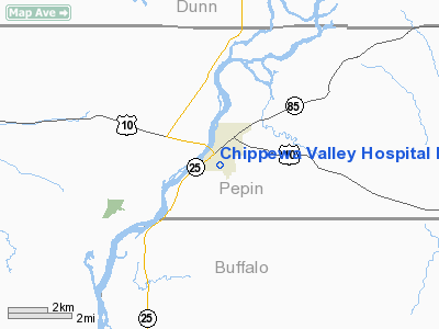
Chippewa Valley Hospital Heliport |
Location & QuickFacts
| FAA Information Effective: | 2008-09-25 |
| Airport Identifier: | WI57 |
| Airport Status: | Operational |
| Longitude/Latitude: | 091-57-45.6120W/44-37-15.8750N
-91.962670/44.621076 (Estimated) |
| Elevation: | 852 ft / 259.69 m (Estimated) |
| Land: | 0 acres |
| From nearest city: | 0 nautical miles N of Durand, WI |
| Location: | Pepin County, WI |
| Magnetic Variation: | 02E (1985) |
Owner & Manager
| Ownership: | Privately owned |
| Owner: | Chippewa Valley Hospital |
| Address: | 1620 Third Ave West
Durand, WI 54736 |
| Phone number: | 715-672-4211 |
| Manager: | Malcolm Cole |
| Address: | 1620 Third Ave West
Durand, WI 54736 |
| Phone number: | 715-672-4211 |
Airport Operations and Facilities
| Airport Use: | Private
MEDICAL. |
| Wind indicator: | Yes |
| Segmented Circle: | No |
| Control Tower: | No |
| Lighting Schedule: | DUSK-DAWN |
| Sectional chart: | Green Bay |
| Region: | AGL - Great Lakes |
| Boundary ARTCC: | ZMP - Minneapolis |
| Tie-in FSS: | GRB - Green Bay |
| FSS Toll Free: | 1-800-WX-BRIEF |
Runway Information
Helipad H1
| Dimension: | 30 x 30 ft / 9.1 x 9.1 m |
| Surface: | ASPH, |
| |
Runway H1 |
Runway |
| Traffic Pattern: | Left | Left |
|
Radio Navigation Aids
| ID |
Type |
Name |
Ch |
Freq |
Var |
Dist |
| RNH | NDB | New Richmond | | 257.00 | 02E | 39.9 nm |
| AHH | NDB | Ameron | | 278.00 | 01E | 43.3 nm |
| PPI | NDB | Hopey | | 400.00 | 03E | 44.5 nm |
| MS | NDB | Narco | | 266.00 | 02E | 49.7 nm |
| ONA | VOR/DME | Winona | 051X | 111.40 | 01E | 34.6 nm |
| RPD | VOR/DME | Rice Lake | 037X | 110.00 | 01E | 48.4 nm |
| EAU | VORTAC | Eau Claire | 076X | 112.90 | 04E | 26.5 nm |
| ODI | VORTAC | Nodine | 126X | 117.90 | 01E | 47.6 nm |
Remarks
- PRVDD ALL APCH/DEP OPNS 360-030 DEGS & 090-100 DEGS; TAKEOFF/LDG AREA APROPLY MKD; NON-OBSTRUCTING WIND INDICATOR MAINTAINED; RED WIRE HAZARD INDICATORS INSTALLED ON PLINES EAAST; TWO WAY RADIO COMMUNICATIONS BETWEEN HELIPORT & HOSPITAL.
Images and information placed above are from
http://www.airport-data.com/airport/WI57/
We thank them for the data!
| General Info
|
| Country |
United States
|
| State |
WISCONSIN
|
| FAA ID |
WI57
|
| Latitude |
44-37-15.875N
|
| Longitude |
091-57-45.612W
|
| Elevation |
852 feet
|
| Near City |
DURAND
|
We don't guarantee the information is fresh and accurate. The data may
be wrong or outdated.
For more up-to-date information please refer to other sources.
|
|


