 |
|
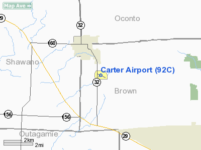
Location & QuickFacts
| FAA Information Effective: | 2008-09-25 |
| Airport Identifier: | 92C |
| Airport Status: | Operational |
| Longitude/Latitude: | 088-12-54.7910W/44-38-28.3920N
-88.215220/44.641220 (Estimated) |
| Elevation: | 785 ft / 239.27 m (Surveyed) |
| Land: | 80 acres |
| From nearest city: | 2 nautical miles S of Pulaski, WI |
| Location: | Brown County, WI |
| Magnetic Variation: | 02W (1985) |
Owner & Manager
| Ownership: | Privately owned |
| Owner: | Plane And Simple Llp |
| Address: | Po Box 457
Green Bay, WI 54305-0457 |
| Phone number: | 920-822-3644 |
| Manager: | Blue Skies Aviation |
| Address: | 3736 State Road 32
Pulaski, WI 54162 |
| Phone number: | 920-822-3644 |
Airport Operations and Facilities
| Airport Use: | Open to public |
| Wind indicator: | Yes |
| Segmented Circle: | Yes |
| Control Tower: | No |
| Lighting Schedule: | RDO-CTL
FOR NSTD LIRL RY 12/30 ACTVT 3 CLICKS ON 5 CLICKS OFF- CTAF |
| Landing fee charge: | No |
| Sectional chart: | Green Bay |
| Region: | AGL - Great Lakes |
| Traffic Pattern Alt: | 800 ft |
| Boundary ARTCC: | ZMP - Minneapolis |
| Tie-in FSS: | GRB - Green Bay |
| FSS on Airport: | No |
| FSS Toll Free: | 1-800-WX-BRIEF
OR LOCAL CALL 494-7417. |
| NOTAMs Facility: | GRB (NOTAM-d service avaliable) |
Airport Communications
Airport Services
| Fuel available: | 100LLMOGAS |
| Airframe Repair: | MAJOR |
| Power Plant Repair: | MAJOR |
| Bottled Oxygen: | NONE |
| Bulk Oxygen: | NONE |
Runway Information
Runway 03/21
| Dimension: | 1610 x 80 ft / 490.7 x 24.4 m
700 FT TURF STWY ON SE END. |
| Surface: | TURF, Fair Condition |
| |
Runway 03 |
Runway 21 |
| Longitude: | 088-13-07.3690W | 088-12-54.3700W |
| Latitude: | 44-38-21.4030N | 44-38-33.9730N |
| Traffic Pattern: | Left | Left |
| Markings: | None, | None, |
| Runway End Identifier: | No | No |
| Centerline Lights: | No | No |
| Touchdown Lights: | No | No |
| Obstruction: | 15 ft road, 400.0 ft from runway, 160 ft left of centerline, 26:1 slope to clear | 15 ft road, 0.0 ft from runway, 70 ft right of centerline |
|
Runway 12/30
| Dimension: | 2555 x 30 ft / 778.8 x 9.1 m
700 FT TURF STWY ON SE END. |
| Surface: | ASPH, Fair Condition |
| Edge Lights: | Non-standard lighting system
NSTD LIRL, SPACED EVERY 300' |
| |
Runway 12 |
Runway 30 |
| Longitude: | 088-13-10.9600W | 088-12-38.6220W |
| Latitude: | 44-38-33.4160N | 44-38-23.3670N |
| Elevation: | 782.00 ft | 774.00 ft |
| Alignment: | 114 | 127 |
| Traffic Pattern: | Left | Left |
| Markings: | Basic, Good Condition | Basic, Good Condition |
| Displaced threshold: | 375.00 ft
NSTD DSPLCD THLD MARKINGS - NO ARROWS. | 130.00 ft |
| Runway End Identifier: | No | No |
| Centerline Lights: | No | No |
| Touchdown Lights: | No | No |
| Obstruction: | 46 ft tree, 340.0 ft from runway, 100 ft right of centerline, 3:1 slope to clear
RWY 12 APCH RATIO 15:1; +13 FT RD 210 FT FM THLD 150 FT L.
8-10 FT BRUSH 150 FT FM THR 90 FT L; +18 FT ROAD AT 40 FT FM THR. | 50 ft trees, 1050.0 ft from runway, 100 ft left of centerline, 17:1 slope to clear
RWY 30 APCH SLOPE 23:1 TO DSPLCD THLD. |
|
Radio Navigation Aids
| ID |
Type |
Name |
Ch |
Freq |
Var |
Dist |
| SG | NDB | Depre | | 332.00 | 02W | 15.0 nm |
| OCQ | NDB | Oconto | | 388.00 | 03W | 19.1 nm |
| CLI | NDB | Clintonville | | 209.00 | 02W | 22.2 nm |
| AQ | NDB | Kooky | | 407.00 | 02W | 26.8 nm |
| SUE | NDB | Sturgeon Bay | | 414.00 | 03W | 35.8 nm |
| PCZ | NDB | Waupaca | | 382.00 | 01W | 39.1 nm |
| AIG | NDB | Antigo | | 347.00 | 02W | 49.3 nm |
| MTW | VOR/DME | Manitowoc | 047X | 111.00 | 02W | 38.5 nm |
| MNM | VOR/DME | Menominee | 033X | 109.60 | 00E | 40.4 nm |
| GRB | VORTAC | Green Bay | 102X | 115.50 | 01E | 5.2 nm |
| OSH | VORTAC | Oshkosh | 055X | 111.80 | 02E | 41.8 nm |
Remarks
- PAJA ON ARPT.
- ULTRA-LIGHT FLYING ON & INVOF ARPT.
- LIMITED LINE-OF-SIGHT BETWEEN RYS 03 & 12; RYS 03 & 30.
Images and information placed above are from
http://www.airport-data.com/airport/92C/
We thank them for the data!
| General Info
|
| Country |
United States
|
| State |
WISCONSIN
|
| FAA ID |
92C
|
| Latitude |
44-38-28.392N
|
| Longitude |
088-12-54.791W
|
| Elevation |
785 feet
|
| Near City |
PULASKI
|
We don't guarantee the information is fresh and accurate. The data may
be wrong or outdated.
For more up-to-date information please refer to other sources.
|
|


