 |
|
| Capitol Airport |
| IATA: none – ICAO: K02C – FAA LID: 02C |
| Summary |
| Airport type |
Public |
| Owner |
Wisconsin Aviation Investments LLC |
| Serves |
Brookfield, Wisconsin |
| Elevation AMSL |
850 ft / 259 m |
| Coordinates |
43°05′15″N 088°10′40″W / 43.0875°N 88.17778°W / 43.0875; -88.17778 |
| Runways |
| Direction |
Length |
Surface |
| ft |
m |
| 3/21 |
3,501 |
1,067 |
Asphalt |
| 9/27 |
3,395 |
1,035 |
Turf |
| 18/36 |
1,600 |
488 |
Turf |
| Statistics (2007) |
| Aircraft operations |
15,150 |
| Based aircraft |
109 |
| Source: Federal Aviation Administration |
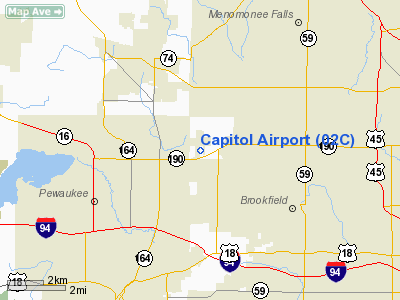
Capitol Airport (ICAO: K02C, FAA LID: 02C) is a public use airport located three nautical miles (6 km) east of the central business district of Brookfield, a city in Waukesha County, Wisconsin, United States. It is privately owned by Wisconsin Aviation Investments LLC. The airport is also known as, or formerly known as Capitol Drive Airport. Facilities and aircraft
Capitol Airport covers an area of 207 acres (84 ha) at an elevation of 850 feet (259 m) above mean sea level. It has one asphalt paved runway designated 3/21 which measures 3,501 x 44 ft. (1,067 x 13 m), plus two turf runways: 9/27 measuring 3,395 x 100 ft. (1,035 x 30 m) and 18/36 measuring 1,600 x 80 ft. (488 x 24 m).
The facility has no published instrument procedures and no instrument navigational aids.
For the 12-month period ending September 7, 2007, the airport had 15,150 aircraft operations, an average of 41 per day: 99% general aviation and 1% military. At that time there were 109 aircraft based at this airport: 94% single-engine, 1% multi-engine, 1% helicopter and 5% ultralight.
Brookfield Aero, LLC is the fixed base operator.
Incidents
- A groundskeeper was seriously injured when he was struck by the propeller of a Cessna 120 taxiing prior to takeoff on September 6, 2002.
- 2 were killed November 21, 1992 when their Piper PA-28-140 crashed while attempting to land in low visibility.
The above content comes from Wikipedia and is published under free licenses – click here to read more.
Location & QuickFacts
| FAA Information Effective: | 2008-09-25 |
| Airport Identifier: | 02C |
| Airport Status: | Operational |
| Longitude/Latitude: | 088-10-40.3290W/43-05-15.0360N
-88.177869/43.087510 (Estimated) |
| Elevation: | 850 ft / 259.08 m (Estimated) |
| Land: | 207 acres |
| From nearest city: | 3 nautical miles E of Brookfield, WI |
| Location: | Waukesha County, WI |
| Magnetic Variation: | 01W (1985) |
Owner & Manager
| Ownership: | Privately owned |
| Owner: | Wisconsin Aviation Investments Llc |
| Address: | 4800 N. Pinecrest Drive
Chenequa, WI 53058 |
| Phone number: | 262-391-0343 |
| Manager: | Matt Byrne |
| Address: | 21500 W Gumina Dr
Pewaukee, WI 53072 |
| Phone number: | 262-781-4213 |
Airport Operations and Facilities
| Airport Use: | Open to public |
| Wind indicator: | Yes |
| Segmented Circle: | Yes |
| Control Tower: | No |
| Lighting Schedule: | DUSK-DAWN
ACTVT MIRL RY 03/21 & VASI RYS 03 & 21 - CTAF. RY 03/21 MIRL OTS INDEFLY. |
| Beacon Color: | Clear-Green (lighted land airport) |
| Landing fee charge: | No |
| Sectional chart: | Chicago |
| Region: | AGL - Great Lakes |
| Traffic Pattern Alt: | 1000 ft |
| Boundary ARTCC: | ZAU - Chicago |
| Tie-in FSS: | GRB - Green Bay |
| FSS on Airport: | No |
| FSS Toll Free: | 1-800-WX-BRIEF |
| NOTAMs Facility: | GRB (NOTAM-d service avaliable) |
| Federal Agreements: | NGY |
Airport Communications
| CTAF: | 122.700 |
| Unicom: | 122.700 |
Airport Services
| Fuel available: | 100LLMOGAS |
Runway Information
Runway 03/21
| Dimension: | 3501 x 44 ft / 1067.1 x 13.4 m |
| Surface: | ASPH, Good Condition |
| Edge Lights: | Non-standard lighting system
NSTD MIRL; RY 03 FIRST 500 FT UNLGTD. |
| |
Runway 03 |
Runway 21 |
| Longitude: | 088-10-50.7400W | 088-10-35.2500W |
| Latitude: | 43-05-04.5600N | 43-05-37.2200N |
| Elevation: | 840.00 ft | 830.00 ft |
| Traffic Pattern: | Left | Left |
| Markings: | Basic, Good Condition
MARKINGS FADED. | Basic, Good Condition
MARKINGS FADED. |
| Displaced threshold: | 500.00 ft | 195.00 ft |
| VASI: | tri-color on left side | tri-color on left side |
| Runway End Identifier: | No | Yes
NSTD REIL; STROBES MOUNTED ON STD EDGE LIGHTING POLES. |
| Centerline Lights: | No | No |
| Touchdown Lights: | No | No |
| Obstruction: | 10 ft road, 200.0 ft from runway
RWY 03 +40 FT TREE 200 FT FM DSPLCD THLD; 100 FT L; 5:1 AT DSPLCD THLD. | 70 ft trees, 1210.0 ft from runway, 14:1 slope to clear
RWY 21 APCH RATIO 20:1 TO DSPLCD THLD. |
|
Runway 09/27
| Dimension: | 3395 x 100 ft / 1034.8 x 30.5 m |
| Surface: | TURF, Fair Condition |
| |
Runway 09 |
Runway 27 |
| Longitude: | 088-10-47.3500W | 088-10-30.3100W |
| Latitude: | 43-05-27.0300N | 43-05-27.0300N |
| Elevation: | 830.00 ft | 830.00 ft |
| Traffic Pattern: | Left | Left |
| Markings: | None,
09/27 & 18/36 ENDS MARKED WITH ORANGE & WHITE A-FRAMES. | None, |
| Runway End Identifier: | No | No |
| Centerline Lights: | No | No |
| Touchdown Lights: | No | No |
| Obstruction: | 50 ft tree, 420.0 ft from runway, 150 ft right of centerline, 8:1 slope to clear | 70 ft trees, 1400.0 ft from runway, 20:1 slope to clear |
|
Runway 18/36
| Dimension: | 1600 x 80 ft / 487.7 x 24.4 m |
| Surface: | TURF, Fair Condition |
| |
Runway 18 |
Runway 36 |
| Traffic Pattern: | Left | Left |
| Markings: | None, | None, |
| Runway End Identifier: | No | No |
| Centerline Lights: | No | No |
| Touchdown Lights: | No | No |
| Obstruction: | 4 ft brush | 40 ft tree, 160.0 ft from runway, 120 ft left of centerline, 4:1 slope to clear |
|
Radio Navigation Aids
| ID |
Type |
Name |
Ch |
Freq |
Var |
Dist |
| UES | NDB | Waukesha | | 359.00 | 01W | 3.6 nm |
| GM | NDB | Teels | | 242.00 | 02W | 12.3 nm |
| BL | NDB | Yanks | | 260.00 | 02W | 13.3 nm |
| HXF | NDB | Hartford | | 200.00 | 00E | 18.4 nm |
| LLE | NDB | Kettle Moraine | | 329.00 | 01W | 20.4 nm |
| RYV | NDB | Rock River | | 371.00 | 01W | 24.6 nm |
| RA | NDB | Paser | | 206.00 | 00E | 27.3 nm |
| LVV | NDB | Lake Lawn | | 404.00 | 00W | 29.7 nm |
| UNU | NDB | Juneau | | 344.00 | 01W | 30.8 nm |
| JVL | NDB | Janesville | | 375.00 | 03E | 47.5 nm |
| BJB | VOR | West Bend | | 109.80 | 01W | 20.2 nm |
| LJT | VOR/DME | Timmerman | 072X | 112.50 | 02W | 6.3 nm |
| BUU | VOR/DME | Burbun | 092X | 114.50 | 01W | 24.5 nm |
| HRK | VOR/DME | Horlick | 124X | 117.70 | 02W | 25.3 nm |
| ENW | VOR/DME | Kenosha | 029X | 109.20 | 02W | 31.3 nm |
| FAH | VOR/DME | Falls | 37X | 110.00 | 02W | 43.4 nm |
| BAE | VORTAC | Badger | 111X | 116.40 | 02E | 5.0 nm |
| MKE | VOT | Milwaukee | | 109.00 | | 14.9 nm |
Remarks
- RYS 03 & 36 ACFT OPNS CANNOT SEE RY 27 ACFT OPNS.
- RYS 09/27 & 18/36 NOT SANDED OR PLOWED. CONFIRM CONDS & SNOW REMOVAL FOR RY 03/21 WITH AMGR 262-781-4213.
- INTENSIVE FLIGHT TRAINING POWERED ACFT.
- RYS 09/27 & 18/36 OPEN FOR SKI EQUIPPED ACFT DEC 1 THRU APR 15.
- BE ALERT: CONSTANT MOWING OPNS ON & INVOF RYS AND ADJ AREAS.
- AIRSPACE DETERMINATION: PENDING.
Images and information placed above are from
http://www.airport-data.com/airport/02C/
We thank them for the data!
| General Info
|
| Country |
United States
|
| State |
WISCONSIN
|
| FAA ID |
02C
|
| Latitude |
43-05-15.036N
|
| Longitude |
088-10-40.329W
|
| Elevation |
850 feet
|
| Near City |
BROOKFIELD
|
We don't guarantee the information is fresh and accurate. The data may
be wrong or outdated.
For more up-to-date information please refer to other sources.
|
|


