 |
|
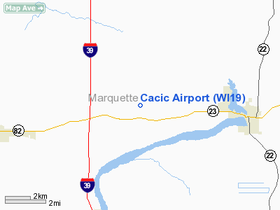
Location & QuickFacts
| FAA Information Effective: | 2008-09-25 |
| Airport Identifier: | WI19 |
| Airport Status: | Operational |
| Longitude/Latitude: | 089-26-00.4360W/43-47-59.9200N
-89.433454/43.799978 (Estimated) |
| Elevation: | 805 ft / 245.36 m (Surveyed) |
| Land: | 6 acres |
| From nearest city: | 4 nautical miles W of Montello, WI |
| Location: | Marquette County, WI |
| Magnetic Variation: | 00W (1985) |
Owner & Manager
| Ownership: | Privately owned |
| Owner: | Walter Cacic |
| Address: | W5476 State Road 23
Montello, WI 53949-8042 |
| Phone number: | 608-589-5594 |
| Manager: | Donald Cacic |
| Address: | Rr 3
Montello, WI 53949 |
| Phone number: | 608-589-5327 |
Airport Operations and Facilities
| Airport Use: | Private |
| Wind indicator: | Yes |
| Segmented Circle: | No |
| Control Tower: | No |
| Landing fee charge: | No |
| Sectional chart: | Chicago |
| Region: | AGL - Great Lakes |
| Traffic Pattern Alt: | 800 ft |
| Boundary ARTCC: | ZAU - Chicago |
| Tie-in FSS: | GRB - Green Bay |
| FSS on Airport: | No |
| FSS Toll Free: | 1-800-WX-BRIEF |
Airport Services
| Airframe Repair: | NONE |
| Power Plant Repair: | NONE |
| Bottled Oxygen: | NONE |
| Bulk Oxygen: | NONE |
Runway Information
Runway 09/27
| Dimension: | 1850 x 75 ft / 563.9 x 22.9 m |
| Surface: | TURF, Fair Condition |
| |
Runway 09 |
Runway 27 |
| Traffic Pattern: | Left | Left |
| Runway End Identifier: | No | No |
| Centerline Lights: | No | No |
| Touchdown Lights: | No | No |
| Obstruction: | 20 ft bldgs, 40.0 ft from runway, 30 ft right of centerline, 2:1 slope to clear
+30' TREES | , 30.0 ft from runway, 2:1 slope to clear
+45' TREE 85' RIGHT OF CNTRLN. |
|
Radio Navigation Aids
| ID |
Type |
Name |
Ch |
Freq |
Var |
Dist |
| PCZ | NDB | Waupaca | | 382.00 | 01W | 36.7 nm |
| ISW | NDB | Wisconsin Rapids | | 215.00 | 01W | 38.2 nm |
| UNU | NDB | Juneau | | 344.00 | 01W | 38.9 nm |
| HBW | NDB | Kickapoo | | 251.00 | 03E | 40.0 nm |
| MS | NDB | Monah | | 400.00 | 00E | 44.5 nm |
| RYV | NDB | Rock River | | 371.00 | 01W | 48.7 nm |
| VOK | TACAN | Volk | 041X | | 00E | 36.8 nm |
| LNR | VOR/DME | Lone Rock | 075X | 112.80 | 00E | 43.0 nm |
| DLL | VORTAC | Dells | 117X | 117.00 | 03E | 20.7 nm |
| MSN | VORTAC | Madison | 023X | 108.60 | 03E | 39.6 nm |
| OSH | VORTAC | Oshkosh | 055X | 111.80 | 02E | 39.7 nm |
| STE | VORTAC | Stevens Point | 043X | 110.60 | 01W | 44.9 nm |
Remarks
- RWY NOT PLOWED WINTER MONTHS AND CLSD EXCPT SKI ACFTS.
Images and information placed above are from
http://www.airport-data.com/airport/WI19/
We thank them for the data!
| General Info
|
| Country |
United States
|
| State |
WISCONSIN
|
| FAA ID |
WI19
|
| Latitude |
43-47-59.920N
|
| Longitude |
089-26-00.436W
|
| Elevation |
805 feet
|
| Near City |
MONTELLO
|
We don't guarantee the information is fresh and accurate. The data may
be wrong or outdated.
For more up-to-date information please refer to other sources.
|
|


