 |
|
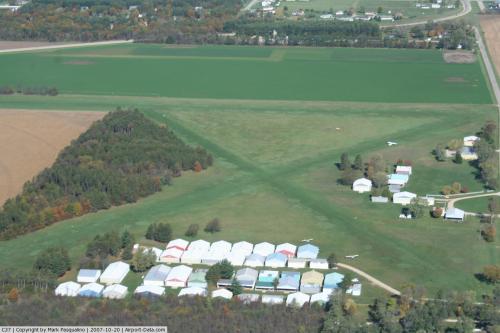 |
(Click on the photo to enlarge) |
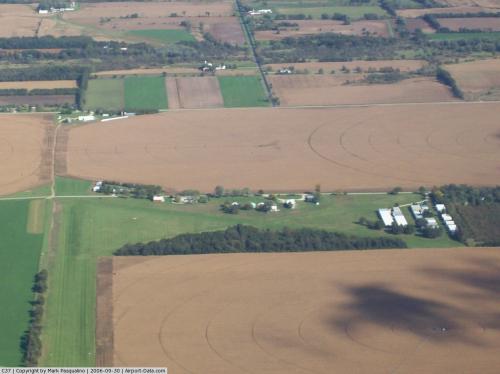 |
(Click on the photo to enlarge) |
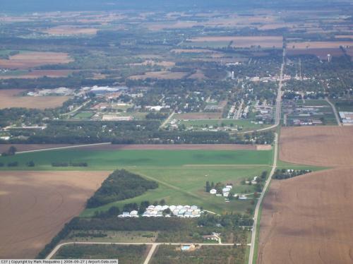 |
(Click on the photo to enlarge) |
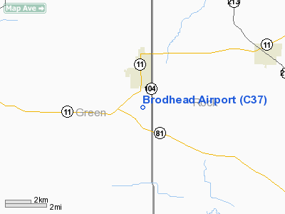
Location & QuickFacts
| FAA Information Effective: | 2008-09-25 |
| Airport Identifier: | C37 |
| Airport Status: | Operational |
| Longitude/Latitude: | 089-22-30.4190W/42-35-30.0350N
-89.375116/42.591676 (Estimated) |
| Elevation: | 793 ft / 241.71 m (Estimated) |
| Land: | 86 acres |
| From nearest city: | 2 nautical miles S of Brodhead, WI |
| Location: | Green County, WI |
| Magnetic Variation: | 00E (1985) |
Owner & Manager
| Ownership: | Privately owned |
| Owner: | Hawk Aire Inc. |
| Address: | 4654 River Road
Janesville, WI 53545 |
| Phone number: | 608-752-5474 |
| Manager: | Lee Stenson |
| Address: | N2463 Brodhead Arpt Rd
Brodhead, WI 53520 |
| Phone number: | 608-897-4000 |
Airport Operations and Facilities
| Airport Use: | Open to public |
| Wind indicator: | Yes |
| Segmented Circle: | No |
| Control Tower: | No |
| Lighting Schedule: | RDO-CTL
ACTVT LIRL RY 09/27 - CTAF. |
| Landing fee charge: | No |
| Sectional chart: | Chicago |
| Region: | AGL - Great Lakes |
| Boundary ARTCC: | ZAU - Chicago |
| Tie-in FSS: | GRB - Green Bay |
| FSS on Airport: | No |
| FSS Toll Free: | 1-800-WX-BRIEF |
| NOTAMs Facility: | GRB (NOTAM-d service avaliable) |
Airport Communications
Airport Services
| Bottled Oxygen: | NONE |
| Bulk Oxygen: | NONE |
Runway Information
Runway 03/21
| Dimension: | 1480 x 100 ft / 451.1 x 30.5 m |
| Surface: | TURF, Fair Condition |
| |
Runway 03 |
Runway 21 |
| Longitude: | 089-22-49.5000W | 089-22-38.3300W |
| Latitude: | 42-35-35.9600N | 42-35-48.1200N |
| Elevation: | 793.00 ft | 793.00 ft |
| Traffic Pattern: | Left | Left |
| Runway End Identifier: | No | No |
| Centerline Lights: | No | No |
| Touchdown Lights: | No | No |
| Obstruction: | 42 ft trees, 400.0 ft from runway, 90 ft right of centerline, 9:1 slope to clear | 17 ft road, 340.0 ft from runway, 150 ft left of centerline, 20:1 slope to clear |
|
Runway 09/27
| Dimension: | 2430 x 155 ft / 740.7 x 47.2 m |
| Surface: | TURF, Fair Condition |
| Edge Lights: | Low |
| |
Runway 09 |
Runway 27 |
| Longitude: | 089-23-18.6500W | 089-22-46.1900W |
| Latitude: | 42-35-49.0500N | 42-35-50.0100N |
| Elevation: | 793.00 ft | 793.00 ft |
| Traffic Pattern: | Left | Left |
| Runway End Identifier: | No | No |
| Centerline Lights: | No | No |
| Touchdown Lights: | No | No |
| Obstruction: | 40 ft tree, 600.0 ft from runway, 150 ft left of centerline, 15:1 slope to clear | 31 ft trees, 630.0 ft from runway, 140 ft left of centerline, 20:1 slope to clear |
|
Runway 15/33
| Dimension: | 1380 x 100 ft / 420.6 x 30.5 m |
| Surface: | TURF, Fair Condition |
| |
Runway 15 |
Runway 33 |
| Longitude: | 089-22-54.3800W | 089-22-43.4600W |
| Latitude: | 42-35-48.9800N | 42-35-36.0800N |
| Elevation: | 793.00 ft | 793.00 ft |
| Traffic Pattern: | Left | Left |
| Runway End Identifier: | No | No |
| Centerline Lights: | No | No |
| Touchdown Lights: | No | No |
| Obstruction: | 40 ft trees, 100 ft right of centerline | 40 ft trees, 600.0 ft from runway, 50 ft left of centerline, 15:1 slope to clear |
|
Radio Navigation Aids
| ID |
Type |
Name |
Ch |
Freq |
Var |
Dist |
| JVL | NDB | Janesville | | 375.00 | 03E | 14.8 nm |
| FEP | NDB | Freeport | | 335.00 | 00E | 22.8 nm |
| MS | NDB | Monah | | 400.00 | 00E | 28.3 nm |
| LVV | NDB | Lake Lawn | | 404.00 | 00W | 35.2 nm |
| MRJ | NDB | Mineral Point | | 365.00 | 00W | 41.6 nm |
| RYV | NDB | Rock River | | 371.00 | 01W | 45.2 nm |
| PVB | NDB | Platteville | | 203.00 | 01E | 47.3 nm |
| DKB | NDB | Dekalb | | 209.00 | 02W | 49.4 nm |
| JVL | VOR/DME | Janesville | 090X | 114.30 | 03E | 12.1 nm |
| RFD | VOR/DME | Rockford | 045X | 110.80 | 01E | 23.3 nm |
| PLL | VOR/DME | Polo | 049X | 111.20 | 03E | 38.2 nm |
| BUU | VOR/DME | Burbun | 092X | 114.50 | 01W | 47.8 nm |
| MSN | VORTAC | Madison | 023X | 108.60 | 03E | 33.3 nm |
Remarks
- RWYS NOT PLOWED WINTERS; OPEN TO SKI ACFT.
- CROP DUSTING OPNS IN AREA.
- E111: DETERMINATION PENDING
Images and information placed above are from
http://www.airport-data.com/airport/C37/
We thank them for the data!
| General Info
|
| Country |
United States
|
| State |
WISCONSIN
|
| FAA ID |
C37
|
| Latitude |
42-35-30.035N
|
| Longitude |
089-22-30.419W
|
| Elevation |
793 feet
|
| Near City |
BRODHEAD
|
We don't guarantee the information is fresh and accurate. The data may
be wrong or outdated.
For more up-to-date information please refer to other sources.
|
|


