 |
|
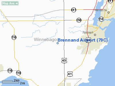
Location & QuickFacts
| FAA Information Effective: | 2008-09-25 |
| Airport Identifier: | 79C |
| Airport Status: | Operational |
| Longitude/Latitude: | 088-33-34.3970W/44-09-35.9430N
-88.559555/44.159984 (Estimated) |
| Elevation: | 850 ft / 259.08 m (Estimated) |
| Land: | 22 acres |
| From nearest city: | 4 nautical miles SW of Neenah, WI |
| Location: | Winnebago County, WI |
| Magnetic Variation: | 01W (1985) |
Owner & Manager
| Ownership: | Privately owned |
| Owner: | Plane Flying Llc |
| Address: | 7355 Sunburst Lane
Neenah, WI 54956 |
| Phone number: | 920-836-3081 |
| Manager: | Ted Vander Wielen |
| Address: | 7355 Sunburst Lane
Neenah, WI 54956 |
| Phone number: | 920-836-3081
OTHER NUMBER 920-475-6179. |
Airport Operations and Facilities
| Airport Use: | Open to public |
| Wind indicator: | Yes |
| Segmented Circle: | No |
| Control Tower: | No |
| Lighting Schedule: | RDO CTL
ACTVT NSTD LIRL RY 18/36 5 CLICKS ON 8 CLICKS OFF - CTAF. |
| Landing fee charge: | No |
| Sectional chart: | Green Bay |
| Region: | AGL - Great Lakes |
| Boundary ARTCC: | ZMP - Minneapolis |
| Tie-in FSS: | GRB - Green Bay |
| FSS on Airport: | No |
| FSS Toll Free: | 1-800-WX-BRIEF |
| NOTAMs Facility: | GRB (NOTAM-d service avaliable) |
Airport Communications
Airport Services
| Fuel available: | 100LL |
| Airframe Repair: | MAJOR
CALL 920-475-6179 FOR REPAIR. |
| Power Plant Repair: | MAJOR |
| Bottled Oxygen: | NONE |
| Bulk Oxygen: | NONE |
Runway Information
Runway 18/36
| Dimension: | 2450 x 20 ft / 746.8 x 6.1 m |
| Surface: | ASPH, Fair Condition |
| Edge Lights: | Non-standard lighting system
RY 18/36 NSTD LIRL 1 THR LGHT EACH SIDE OF THLD. |
| |
Runway 18 |
Runway 36 |
| Traffic Pattern: | Left | Left |
| Markings: | Nonstandard,
RY 18 & RY 36 WHITE BAR & CENTERLINE. | Nonstandard, |
| Displaced threshold: | 188.00 ft | 275.00 ft |
| Runway End Identifier: | No
RY 18 RY 18/36 HAS 2 FLASHING LGTS 75 FT NORTH OF RY 18 THLD & 15 FT SOUTH OF RY 36 THLD. | No |
| Centerline Lights: | No | No |
| Touchdown Lights: | No | No |
| Obstruction: | 47 ft trees, 900.0 ft from runway, 50 ft left of centerline, 14:1 slope to clear
RY 18 APCH SLOPE 23:1 FM DSPLCD THLD.
RY 18 +25 FT TREES 180 FT FM THLD 100 FT R. | 43 ft , 590.0 ft from runway, 135 ft right of centerline, 9:1 slope to clear
APCH SLOPE 20:1 FM DSPLCD THLD.
RY 36 +15 FT RD 60 FT FM THR. |
|
Radio Navigation Aids
| ID |
Type |
Name |
Ch |
Freq |
Var |
Dist |
| AQ | NDB | Kooky | | 407.00 | 02W | 7.7 nm |
| PCZ | NDB | Waupaca | | 382.00 | 01W | 22.2 nm |
| SG | NDB | Depre | | 332.00 | 02W | 23.3 nm |
| CLI | NDB | Clintonville | | 209.00 | 02W | 28.6 nm |
| UNU | NDB | Juneau | | 344.00 | 01W | 44.4 nm |
| LLE | NDB | Kettle Moraine | | 329.00 | 01W | 48.0 nm |
| HXF | NDB | Hartford | | 200.00 | 00E | 49.3 nm |
| BJB | VOR | West Bend | | 109.80 | 01W | 48.2 nm |
| MTW | VOR/DME | Manitowoc | 047X | 111.00 | 02W | 38.0 nm |
| FAH | VOR/DME | Falls | 37X | 110.00 | 02W | 38.7 nm |
| OSH | VORTAC | Oshkosh | 055X | 111.80 | 02E | 10.2 nm |
| GRB | VORTAC | Green Bay | 102X | 115.50 | 01E | 28.5 nm |
| STE | VORTAC | Stevens Point | 043X | 110.60 | 01W | 47.7 nm |
Images and information placed above are from
http://www.airport-data.com/airport/79C/
We thank them for the data!
| General Info
|
| Country |
United States
|
| State |
WISCONSIN
|
| FAA ID |
79C
|
| Latitude |
44-09-35.943N
|
| Longitude |
088-33-34.397W
|
| Elevation |
850 feet
|
| Near City |
NEENAH
|
We don't guarantee the information is fresh and accurate. The data may
be wrong or outdated.
For more up-to-date information please refer to other sources.
|
|


