 |
|
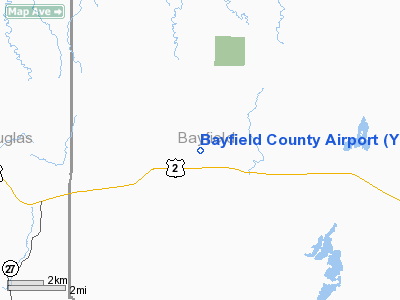
Location & QuickFacts
| FAA Information Effective: | 2008-09-25 |
| Airport Identifier: | Y77 |
| Airport Status: | Operational |
| Longitude/Latitude: | 091-27-30.6800W/46-34-34.7870N
-91.458522/46.576330 (Estimated) |
| Elevation: | 1143 ft / 348.39 m (Estimated) |
| Land: | 120 acres |
| From nearest city: | 2 nautical miles NW of Iron River, WI |
| Location: | Bayfield County, WI |
| Magnetic Variation: | 01E (1985) |
Owner & Manager
| Ownership: | Privately owned |
| Owner: | John Pearson/terry Kohler |
| Address: | Box 897
Sheboygan, WI 53082 |
| Phone number: | 800-842-6798 |
| Manager: | Jim Klinge |
| Address: | Box 897
Sheboygan, WI 53082 |
| Phone number: | 715-372-8729 |
Airport Operations and Facilities
| Airport Use: | Open to public |
| Wind indicator: | Yes |
| Segmented Circle: | No |
| Control Tower: | No |
| Lighting Schedule: | RDO-CTL
ACTVT LIRL RY 08/26 - CTAF. |
| Landing fee charge: | No |
| Sectional chart: | Green Bay |
| Region: | AGL - Great Lakes |
| Boundary ARTCC: | ZMP - Minneapolis |
| Tie-in FSS: | GRB - Green Bay |
| FSS on Airport: | No |
| FSS Toll Free: | 1-800-WX-BRIEF |
| NOTAMs Facility: | GRB (NOTAM-d service avaliable) |
Airport Communications
Airport Services
| Airframe Repair: | NONE |
| Power Plant Repair: | NONE |
Runway Information
Runway 08/26
| Dimension: | 3000 x 130 ft / 914.4 x 39.6 m |
| Surface: | TURF, Fair Condition |
| Edge Lights: | Non-standard lighting system
NSTD LIRL - 1 LGT EA SIDE OF THLD. |
| |
Runway 08 |
Runway 26 |
| Longitude: | 091-27-43.3700W | 091-27-00.6800W |
| Latitude: | 46-34-36.5900N | 46-34-39.7800N |
| Elevation: | 1140.00 ft | 1140.00 ft |
| Traffic Pattern: | Left | Left |
| VASI: | | 2-box on left side |
| Obstruction: | 47 ft trees, 1050.0 ft from runway, 70 ft right of centerline, 22:1 slope to clear | 15 ft road, 350.0 ft from runway, 23:1 slope to clear |
|
Radio Navigation Aids
| ID |
Type |
Name |
Ch |
Freq |
Var |
Dist |
| OLG | NDB | Solon Springs | | 388.00 | 01E | 21.4 nm |
| ENY | NDB | Kennedy | | 254.00 | 02E | 22.5 nm |
| SUW | NDB | Bong | | 260.00 | 01E | 27.5 nm |
| SLY | NDB | Seeley | | 344.00 | 01E | 28.1 nm |
| TWM | NDB | Two Harbors | | 243.00 | 01E | 30.9 nm |
| DL | NDB | Pykla | | 379.00 | 02E | 40.3 nm |
| BFW | NDB | Silver Bay | | 350.00 | 00E | 40.6 nm |
| COQ | NDB | Cloquet | | 335.00 | 03E | 43.7 nm |
| LKI | TACAN | Lakeside | 011X | | 05E | 34.0 nm |
| ASX | VOR/DME | Ashland | 039X | 110.20 | 02E | 22.4 nm |
| HYR | VOR/DME | Hayward | 081X | 113.40 | 03E | 33.5 nm |
| DLH | VORTAC | Duluth | 073X | 112.60 | 05E | 33.6 nm |
Remarks
- CONFIRM WINTER CONDS AND SNOW REMOVAL WITH AMGR 715-372-8333.
- OCCASIONAL WILD GAME ON & INVOF ARPT.
- MAN-MADE OR NATURAL OBJECTS EXIST WITHIN THE AIRSPACE NEEDED TO INSURE SAFETY IN TAKEOFF AND LANDING OF AIRCRAFT.
Images and information placed above are from
http://www.airport-data.com/airport/Y77/
We thank them for the data!
| General Info
|
| Country |
United States
|
| State |
WISCONSIN
|
| FAA ID |
Y77
|
| Latitude |
46-34-34.787N
|
| Longitude |
091-27-30.680W
|
| Elevation |
1143 feet
|
| Near City |
IRON RIVER
|
We don't guarantee the information is fresh and accurate. The data may
be wrong or outdated.
For more up-to-date information please refer to other sources.
|
|


