 |
|
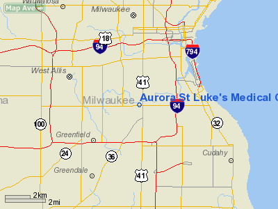
Aurora St Luke's Medical Center Heliport |
Location & QuickFacts
| FAA Information Effective: | 2008-09-25 |
| Airport Identifier: | 0WI0 |
| Airport Status: | Operational |
| Longitude/Latitude: | 087-57-05.3060W/42-59-20.0530N
-87.951474/42.988904 (Estimated) |
| Elevation: | 761 ft / 231.95 m (Estimated) |
| Land: | 0 acres |
| From nearest city: | 1 nautical miles N of Milwaukee, WI |
| Location: | Milwaukee County, WI |
| Magnetic Variation: | 01W (1985) |
Owner & Manager
| Ownership: | Privately owned |
| Owner: | Aurora Health Care Metro |
| Address: | 2900 W. Oklahoma Ave
Milwaukee, WI 53215 |
| Phone number: | 414-649-6000 |
| Manager: | Robert E. Desjarais |
| Address: | 2900 W. Oklahoma Ave
Milwaukee, WI 53215 |
| Phone number: | 414-649-6225 |
Airport Operations and Facilities
| Airport Use: | Private
MEDICAL USE. |
| Wind indicator: | Yes |
| Segmented Circle: | No |
| Control Tower: | No |
| Lighting Schedule: | PHONE REQ
FOR LIRL RY H1 CALL 414-649-6000. |
| Landing fee charge: | No |
| Sectional chart: | Chicago |
| Region: | AGL - Great Lakes |
| Boundary ARTCC: | ZAU - Chicago |
| Tie-in FSS: | GRB - Green Bay |
| FSS on Airport: | No |
| FSS Toll Free: | 1-800-WX-BRIEF |
Airport Services
| Airframe Repair: | NONE |
| Power Plant Repair: | NONE |
Runway Information
Helipad H1
| Dimension: | 43 x 44 ft / 13.1 x 13.4 m |
| Surface: | ALUM,
ROOFTOP. |
| Edge Lights: | Low |
| |
Runway H1 |
Runway |
| Traffic Pattern: | Left | Left |
|
Radio Navigation Aids
| ID |
Type |
Name |
Ch |
Freq |
Var |
Dist |
| BL | NDB | Yanks | | 260.00 | 02W | 5.4 nm |
| GM | NDB | Teels | | 242.00 | 02W | 6.2 nm |
| UES | NDB | Waukesha | | 359.00 | 01W | 12.9 nm |
| RA | NDB | Paser | | 206.00 | 00E | 18.6 nm |
| LLE | NDB | Kettle Moraine | | 329.00 | 01W | 27.3 nm |
| HXF | NDB | Hartford | | 200.00 | 00E | 29.1 nm |
| LVV | NDB | Lake Lawn | | 404.00 | 00W | 33.2 nm |
| RYV | NDB | Rock River | | 371.00 | 01W | 35.7 nm |
| UNU | NDB | Juneau | | 344.00 | 01W | 42.2 nm |
| BJB | VOR | West Bend | | 109.80 | 01W | 27.1 nm |
| LJT | VOR/DME | Timmerman | 072X | 112.50 | 02W | 8.2 nm |
| HRK | VOR/DME | Horlick | 124X | 117.70 | 02W | 14.9 nm |
| ENW | VOR/DME | Kenosha | 029X | 109.20 | 02W | 23.4 nm |
| BUU | VOR/DME | Burbun | 092X | 114.50 | 01W | 23.7 nm |
| OBK | VOR/DME | Northbrook | 077X | 113.00 | 02W | 46.1 nm |
| FAH | VOR/DME | Falls | 37X | 110.00 | 02W | 47.1 nm |
| BAE | VORTAC | Badger | 111X | 116.40 | 02E | 16.5 nm |
| MKE | VOT | Milwaukee | | 109.00 | | 3.4 nm |
Remarks
- PRVDD ALL APCH/DEP ROUTES 180-360 DEGS; TAKEOFF/LNDG AREA APPROPRIATELY MARKED; NON-OBSTRUCTING WIND INDICATOR MAINTAINED.
Images and information placed above are from
http://www.airport-data.com/airport/0WI0/
We thank them for the data!
| General Info
|
| Country |
United States
|
| State |
WISCONSIN
|
| FAA ID |
0WI0
|
| Latitude |
42-59-20.053N
|
| Longitude |
087-57-05.306W
|
| Elevation |
761 feet
|
| Near City |
MILWAUKEE
|
We don't guarantee the information is fresh and accurate. The data may
be wrong or outdated.
For more up-to-date information please refer to other sources.
|
|


