 |
|
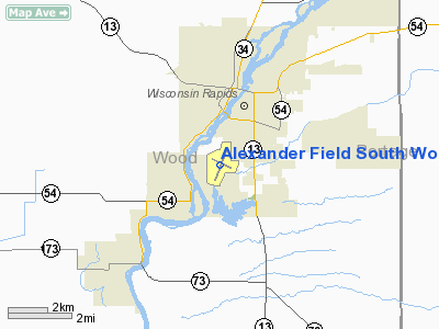
Alexander Field South Wood County Airport |
South Wood County Airport
Alexander Field |
| IATA: ISW – ICAO: KISW – FAA LID: ISW |
| Summary |
| Airport type |
Public |
| Owner/Operator |
City of Wisconsin Rapids
Village of Port Edwards
Town of Grand Rapids
City of Nekoosa |
| Location |
Wisconsin Rapids, Wisconsin |
| Elevation AMSL |
1,021 ft / 311 m |
| Coordinates |
44°21′37″N 089°50′20″W / 44.36028°N 89.83889°W / 44.36028; -89.83889 |
| Runways |
| Direction |
Length |
Surface |
| ft |
m |
| 2/20 |
5,500 |
1,676 |
Asphalt |
| 11/29 |
3,640 |
1,109 |
Asphalt |
| 18/36 |
2,100 |
640 |
Turf |
| Statistics (2006) |
| Aircraft operations |
16,130 |
| Based aircraft |
49 |
| Source: Federal Aviation Administration |
South Wood County Airport (IATA: ISW, ICAO: KISW, FAA LID: ISW), also known as Alexander Field, is a public use airport located one nautical mile (1.85 km) south of the central business district of Wisconsin Rapids, a city in Wood County, Wisconsin, United States.
The airport is owned and operated by the City of Wisconsin Rapids, the Village of Port Edwards, the Town of Grand Rapids, and the City of Nekoosa. Facilities and aircraft
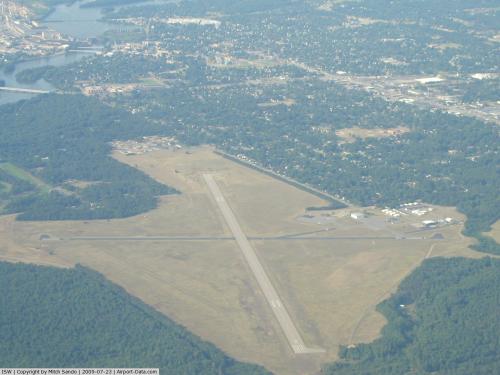
South Wood County Airport covers an area of 435 acres (176 ha) at an elevation of 1,021 feet (311 m) above mean sea level. It has three runways:
- Runway 2/20: 5,500 by 100 feet (1,676 x 30 m), asphalt, SDF equipped
- Runway 11/29: 3,640 by 50 feet (1,109 x 15 m), asphalt
- Runway 18/36: 2,100 by 50 feet (640 x 15 m), turf
- Wisconsin Rapids (ISW) non-directional beacon, 215 kHz, is located on field.
For the 12-month period ending August 16, 2006, the airport had 16,130 aircraft operations, an average of 44 per day: 91% general aviation, 9% air taxi and <1% military. At that time there were 49 aircraft based at this airport: 65% single-engine, 4% multi-engine and 31% ultralight.
The above content comes from Wikipedia and is published under free licenses – click here to read more.
 |
(Click on the photo to enlarge) |
Location & QuickFacts
| FAA Information Effective: | 2008-09-25 |
| Airport Identifier: | ISW |
| Airport Status: | Operational |
| Longitude/Latitude: | 089-50-20.2940W/44-21-37.2180N
-89.838971/44.360338 (Estimated) |
| Elevation: | 1021 ft / 311.20 m (Surveyed) |
| Land: | 435 acres |
| From nearest city: | 1 nautical miles S of Wisconsin Rapids, WI |
| Location: | Wood County, WI |
| Magnetic Variation: | 01W (1995) |
Owner & Manager
| Ownership: | Publicly owned |
| Owner: | Wisconsin Rapids
ALSO VILLAGE OF PORT EDWARDS; TOWN OF GRAND RAPIDS. |
| Address: | 444 W Grand Avenue
Wisconsin Rapids, WI 54495 |
| Phone number: | 715-421-8240 |
| Manager: | Kurt Gross |
| Address: | 3620 1st St So
Wisconsin Rapids, WI 54494 |
| Phone number: | 715-424-3737 |
Airport Operations and Facilities
| Airport Use: | Open to public |
| Wind indicator: | Yes |
| Segmented Circle: | No |
| Control Tower: | No |
| Lighting Schedule: | DUSK-DAWN
ACTVT MIRL RY 02/20; LIRL RY 11/29; REIL RYS 02 & 20; PAPI RYS 02; 20 & 29 - CTAF. |
| Beacon Color: | Clear-Green (lighted land airport) |
| Landing fee charge: | No |
| Sectional chart: | Green Bay |
| Region: | AGL - Great Lakes |
| Boundary ARTCC: | ZMP - Minneapolis |
| Tie-in FSS: | GRB - Green Bay |
| FSS on Airport: | No |
| FSS Toll Free: | 1-800-WX-BRIEF |
| NOTAMs Facility: | ISW (NOTAM-d service avaliable) |
| Federal Agreements: | NGY |
Airport Communications
| CTAF: | 122.800 |
| Unicom: | 122.800 |
Airport Services
Runway Information
Runway 02/20
| Dimension: | 5500 x 100 ft / 1676.4 x 30.5 m |
| Surface: | ASPH, Good Condition |
| Weight Limit: | Single wheel: 40000 lbs.
Dual wheel: 60000 lbs. |
| Edge Lights: | Medium |
| |
Runway 02 |
Runway 20 |
| Longitude: | 089-50-30.6300W | 089-50-05.0100W |
| Latitude: | 44-21-12.0600N | 44-22-03.1700N |
| Elevation: | 1011.00 ft | 1021.00 ft |
| Alignment: | 20 | 127 |
| ILS Type: | SDF
| |
| Traffic Pattern: | Left | Left |
| Markings: | Non-precision instrument, Fair Condition | Non-precision instrument, Fair Condition |
| Crossing Height: | 50.00 ft | 50.00 ft |
| VASI: | 4-light PAPI on left side | 4-light PAPI on left side |
| Visual Glide Angle: | 3.00° | 3.00° |
| Runway End Identifier: | Yes | Yes |
| Centerline Lights: | No | No |
| Touchdown Lights: | No | No |
| Obstruction: | 33 ft trees, 1150.0 ft from runway, 300 ft right of centerline, 28:1 slope to clear | 70 ft tree, 1600.0 ft from runway, 20:1 slope to clear |
|
Runway 11/29
| Dimension: | 3640 x 50 ft / 1109.5 x 15.2 m |
| Surface: | ASPH, Good Condition |
| Weight Limit: | Single wheel: 12000 lbs.
Dual wheel: 20000 lbs. |
| Edge Lights: | Medium |
| |
Runway 11 |
Runway 29 |
| Longitude: | 089-50-39.0600W | 089-49-53.9920W |
| Latitude: | 44-21-47.2400N | 44-21-31.5350N |
| Elevation: | 1020.00 ft | 1012.00 ft |
| Alignment: | 116 | 127 |
| Traffic Pattern: | Left | Left |
| Markings: | Non-precision instrument, Fair Condition | Non-precision instrument, Fair Condition |
| Crossing Height: | 0.00 ft | 50.00 ft |
| Displaced threshold: | 0.00 ft | 170.00 ft |
| VASI: | | 4-light PAPI on left side |
| Visual Glide Angle: | 0.00° | 4.00° |
| Runway End Identifier: | No | No |
| Centerline Lights: | No | No |
| Touchdown Lights: | No | No |
| Obstruction: | 15 ft road, 200.0 ft from runway, 230 ft right of centerline
ROAD 240'R 150'FM THR. | 81 ft trees, 1450.0 ft from runway, 130 ft right of centerline, 15:1 slope to clear
RY 29 APCH RATIO 20:1 AT DSPLCD THLD. |
|
Runway 18/36
| Dimension: | 2100 x 50 ft / 640.1 x 15.2 m |
| Surface: | TURF, Fair Condition |
| |
Runway 18 |
Runway 36 |
| Traffic Pattern: | Left | Left |
| Obstruction: | 55 ft tree, 1250.0 ft from runway, 55 ft right of centerline, 22:1 slope to clear | 42 ft trees, 1800.0 ft from runway, 42:1 slope to clear |
|
Radio Navigation Aids
| ID |
Type |
Name |
Ch |
Freq |
Var |
Dist |
| ISW | NDB | Wisconsin Rapids | | 215.00 | 01W | 0.2 nm |
| MFI | NDB | Marshfield | | 391.00 | 00E | 22.5 nm |
| VIQ | NDB | Neillsville | | 368.00 | 01W | 31.3 nm |
| FZK | NDB | Wausau | | 243.00 | 01E | 35.3 nm |
| PCZ | NDB | Waupaca | | 382.00 | 01W | 35.4 nm |
| CMY | NDB | Mccoy | | 412.00 | 00E | 42.9 nm |
| BCK | NDB | Black River Falls | | 362.00 | 00E | 43.9 nm |
| HBW | NDB | Kickapoo | | 251.00 | 03E | 47.5 nm |
| MDZ | NDB | Medford | | 335.00 | 00E | 49.1 nm |
| CLI | NDB | Clintonville | | 209.00 | 02W | 49.9 nm |
| VOK | TACAN | Volk | 041X | | 00E | 31.0 nm |
| STE | VORTAC | Stevens Point | 043X | 110.60 | 01W | 17.2 nm |
| AUW | VORTAC | Wausau | 053X | 111.60 | 02E | 31.2 nm |
| DLL | VORTAC | Dells | 117X | 117.00 | 03E | 48.8 nm |
Remarks
- BIRDS ON & INVOF ARPT.
- ULTRALIGHT ACFT MUST HAVE AN OPERATING ALTIMETER, TWO-WAY RADIO, USE ULTRALIGHT OPNS AREA (RY 18/36), AVOID OVERFLIGHT OF HARD SFC RYS. ULTRALIGHT OPNS AREA POSTED AT TERMINAL BLDG OR CALL 715-424-3737. WHEN RY 18/36 IS CLSD ULTRALIGHTS MAY USE RYS 02/20 & 11/29.
- ULTRALIGHT ACFT MUST HAVE AN OPERATING ALTIMETER & TWO-WAY RADIO. ULTRALIGHTS USE R TFC FOR RYS 02, 20 & 11 AND L TFC FOR RY 29.
Images and information placed above are from
http://www.airport-data.com/airport/ISW/
We thank them for the data!
| General Info
|
| Country |
United States
|
| State |
WISCONSIN
|
| FAA ID |
ISW
|
| Latitude |
44-21-37.218N
|
| Longitude |
089-50-20.294W
|
| Elevation |
1021 feet
|
| Near City |
WISCONSIN RAPIDS
|
We don't guarantee the information is fresh and accurate. The data may
be wrong or outdated.
For more up-to-date information please refer to other sources.
|
|


