|
 |
|
||||
|
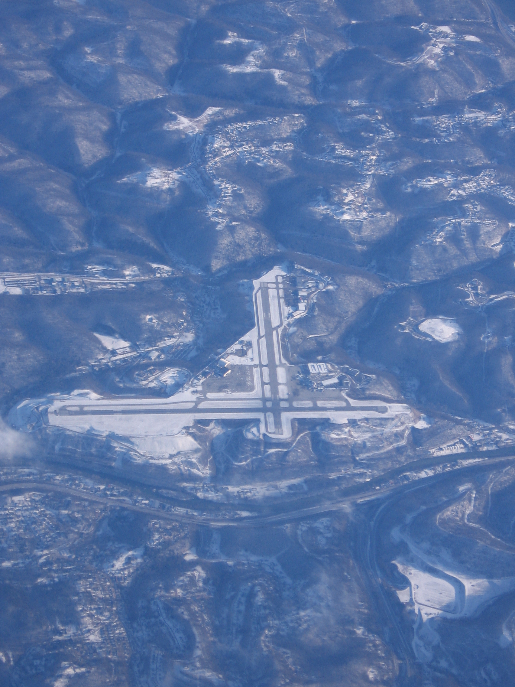
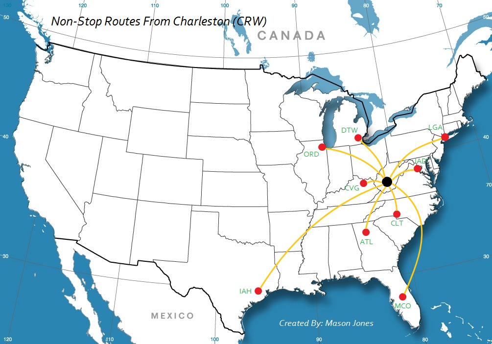
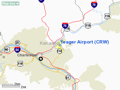
Yeager Airport (IATA: CRW, ICAO: KCRW, FAA LID: CRW) is a joint civil-military public airport located three miles (5 km) east of the central business district (CBD) of Charleston, a city in Kanawha County, West Virginia, USA. The airport covers 767 acres (3.1 km²) and has two runways. It is also home to nine C-130 Hercules aircraft of the Air National Guard's 130th Airlift Wing (130 AW), an Air Mobility Command (AMC)-gained unit of the West Virginia Air National Guard. The airport sits on a hilltop over 300 feet (about 100 m) above the valleys of the Elk and Kanawha Rivers, and the hill drops off sharply on all sides. Due to the airfield's unusual location, passengers flying into Yeager enjoy a scenic approach of either downtown Charleston, or the rolling hills to the north and east of the field. Technical InformationYeager's main runway, Runway 5/23, currently sits on a heading of 235° and is 6,802 feet (2,073 m) in length. An Engineered Materials Arresting System (EMAS) was recently built at the end of Runway 5 to prevent aircraft from being able to go over the hillside, in the unlikely event that one wouldn't be able to stop. Yeager's secondary runway, Runway 15/33, is currently closed. Its heading is 335° and is 4,750 feet (1,450 m) in length. Runway 15/33 was mostly used by general aviation aircraft due to its length, although the smaller regional jets and turboprops have used it before when winds are heavy out of the north. HistoryDuring World War II, Charleston's airport at that time, Wertz Field, closed when the airport's approaches were blocked once the federal government built a synthetic rubber plant next to the airport; this left the city without an airport. However, there were plans before the war to build a new Charleston airport, as Wertz Field was already becoming commercially obsolete. The city started construction of its new airport in 1944; the facility opened in 1947 as Kanawha Airport. The airport received its current name in 1985, honoring then-Brigadier General Chuck Yeager, a native of nearby Lincoln County who piloted the world's first supersonic flight in the Bell X-1. On February 27, 2008, Yeager's Governing Board voted to close the secondary runway, Rwy 15/33, to allow for the construction of two new hangars and additional ramp space for four additional C-130s to be based at the Air National Guard facility. It will allow the airport to triple the general aviation area's hangar space and create room for off-runway businesses, and provide parking for up to ten additional commercial airliners. 5 million dollars were given to the airport to build a canopy around the front of the terminal. Also, and additional 2 million have been given to create a covered walk-way from the main terminal to the airports parking garage. Airlines and destinations
Accidents and incidentsOn January 10, 2009 Colgan Air flight 6880 on behalf of United Airlines reported a hydraulics leak. The pilot was able to pump down the left wing gear. 13 passengers, and 3 crew were on the aircraft, no one was hurt. The aircraft landed safely on runway 23. On July 13, 2009, Southwest Airlines Flight 2294 from Nashville International Airport to Baltimore-Washington International Airport was forced to divert to Yeager Airport in Charleston, West Virginia after a hole formed on the top of the plane's fuselage near the tail resulting in depressurization of the cabin and deployment of the oxygen masks. All 133 passengers and crew landed safely and a spare plane was flown in to take the passengers to Baltimore. On January 19, 2010, PSA Airlines Canadair CRJ-200 N246PS performing flight JIA-2495/US-2495 to Charlotte, North Carolina on behalf of US Airways with 30 passengers and 3 crew, overran the runway following a rejected take-off at 16:13 local time (21:13 UTC). The aircraft was stopped by the EMAS at the end of the runway, sustaining substantial damage to its undercarriage. On February 8, 2010, a Freedom Airlines Embraer ERJ-145 performing flight F8-6121/DL-6121 to Cincinnati/Northern Kentucky Airport on behalf of Delta Air Lines with 46 passengers and 3 crew, rejected takeoff from Charleston at high speed and came to a safe stop about 400 feet (122 meters) short of the runway end. Both right main gear tires exploded, and the fragments substantially damaged the flaps. On July 28th, 2010, a United Airlines Boeing 757 from Washington Dulles International Airport to San Diego Airport was forced to divert to Yeager Airport in Charleston, West Virginia after smoke was detected in a restroom. None of the 178 passengers and crew members aboard the flight was injured in the incident. The above content comes from Wikipedia and is published under free licenses – click here to read more.
Location & QuickFacts
Owner & Manager
Airport Operations and Facilities
Airport Communications
Airport Services
Runway InformationRunway 05/23
Runway 15/33
Radio Navigation Aids
Remarks
Images and information placed above are from We thank them for the data!
We don't guarantee the information is fresh and accurate. The data may
be wrong or outdated.
|
|||||||||||||||||||||||||||||||||||||||||||||||||||||||||||||||||||||||||||||||||||||||||||||||||||||||||||||||||||||||||||||||||||||||||||||||||||||||||||||||||||||||||||||||||||||||||||||||||||||||||||||||||||||||||||||||||||||||||||||||||||||||||||||||||||||||||||||||||||||||||||||||||||||||||||||||||||||||||||||||||||||||||||||||||||||||||||||||||||||||||||||||||||||||||||||||||||||||

 |
|
Copyright 2004-2026 © by Airports-Worldwide.com, Vyshenskoho st. 36, Lviv 79010, Ukraine Legal Disclaimer |