 |
|
Coordinates: 40°10′30″N 080°38′47″W / 40.175°N 80.64639°W / 40.175; -80.64639
| Wheeling Ohio County Airport |
| IATA: HLG – ICAO: KHLG – FAA LID: HLG |
| Summary |
| Airport type |
Public |
| Owner |
Ohio County Commission |
| Serves |
Wheeling, West Virginia |
| Elevation AMSL |
1,195 ft / 364 m |
| Runways |
| Direction |
Length |
Surface |
| ft |
m |
| 3/21 |
5,001 |
1,524 |
Asphalt |
| 16/34 |
4,497 |
1,371 |
Asphalt |
| Statistics (2004) |
| Aircraft operations |
52,832 |
| Based aircraft |
64 |
| Source: Federal Aviation Administration |
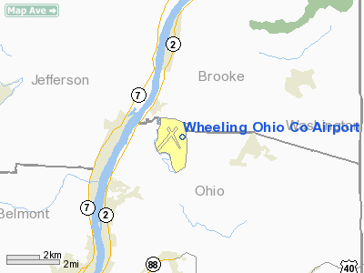
Wheeling Ohio County Airport (IATA: HLG, ICAO: KHLG, FAA LID: HLG) is a public airport serving the city of Wheeling and Ohio County in the U.S. state of West Virginia. It is located eight miles (13 km) northeast of the central business district of Wheeling and the northern portion of the airport situated in Brooke County, southeast of Short Creek and Windsor Heights. The airport is owned by the Ohio County Commission.
Facilities and aircraft
Wheeling Ohio County Airport covers an area of 1,000 acres (405 ha) which contains two asphalt paved runways: 3/21 measuring 5,001 x 150 ft. (1,524 x 46 m) and 16/34 measuring 4,497 x 150 ft. (1,371 x 46 m).
For the 12-month period ending July 15, 2004, the airport had 52,832 aircraft operations, an average of 144 per day: 53% general aviation, 45% military and 2% air taxi. There are 64 aircraft based at this airport: 47% single engine, 19% ultralights, 19% military, 13% multi-engine and 3% jet aircraft.
The above content comes from Wikipedia and is published under free licenses – click here to read more.
Location & QuickFacts
| FAA Information Effective: | 2008-09-25 |
| Airport Identifier: | HLG |
| Airport Status: | Operational |
| Longitude/Latitude: | 080-38-46.6000W/40-10-30.0000N
-80.646278/40.175000 (Estimated) |
| Elevation: | 1195 ft / 364.24 m (Surveyed) |
| Land: | 1000 acres |
| From nearest city: | 8 nautical miles NE of Wheeling, WV |
| Location: | Brooke County, WV |
| Magnetic Variation: | 07W (1985) |
Owner & Manager
| Ownership: | Publicly owned |
| Owner: | Ohio Co Comsn |
| Address: | 1500 Chaplin St
Wheeling, WV 26003 |
| Phone number: | 304-234-3628 |
| Manager: | Thomas S. Tominack |
| Address: | Rt 5, Box 5
Wheeling, WV 26003 |
| Phone number: | 304-234-3865 |
Airport Operations and Facilities
| Airport Use: | Open to public |
| Wind indicator: | Yes |
| Segmented Circle: | No |
| Control Tower: | Yes |
| Lighting Schedule: | DUSK-DAWN
WHEN ATCT CLSD ACTVT HIRL RY 03/21, MIRL RY 16/34, MALSF RY 03, VASI RY 21, PAPI RY 34, REIL RYS 21 & 34, & ALL TWY LGTS EXCEPT TWY A - CTAF. |
| Beacon Color: | Clear-Green (lighted land airport) |
| Sectional chart: | Cincinnati |
| Region: | AEA - Eastern |
| Boundary ARTCC: | ZOB - Cleveland |
| Tie-in FSS: | EKN - Elkins |
| FSS on Airport: | No |
| FSS Toll Free: | 1-800-WX-BRIEF |
| NOTAMs Facility: | HLG (NOTAM-d service avaliable) |
| Federal Agreements: | NGY |
Airport Communications
| CTAF: | 118.100 |
| Unicom: | 122.950 |
Airport Services
| Fuel available: | 100LLA
FOR EMERG FUEL CALL 304-234-3865/336-7738. |
| Airframe Repair: | MAJOR |
| Power Plant Repair: | MINOR |
| Bottled Oxygen: | NONE |
| Bulk Oxygen: | NONE |
Runway Information
Runway 03/21
| Dimension: | 5001 x 150 ft / 1524.3 x 45.7 m |
| Surface: | ASPH, Good Condition |
| Surface Treatment: | Saw-cut or plastic Grooved |
| Weight Limit: | Single wheel: 120000 lbs.
Dual wheel: 170000 lbs.
Dual tandem wheel: 290000 lbs. |
| Edge Lights: | High |
| |
Runway 03 |
Runway 21 |
| Longitude: | 080-39-04.7191W | 080-38-36.4624W |
| Latitude: | 40-10-06.8358N | 40-10-51.2588N |
| Elevation: | 1170.00 ft | 1195.00 ft |
| Alignment: | 26 | 127 |
| ILS Type: | ILS
| |
| Traffic Pattern: | Left | Left |
| Markings: | Precision instrument, Good Condition | Precision instrument, Good Condition |
| Crossing Height: | 0.00 ft | 42.00 ft |
| VASI: | | 4-box on left side |
| Visual Glide Angle: | 0.00° | 3.00° |
| Approach lights: | MALSF | |
| Runway End Identifier: | | Yes
REIL RY 21 OTS INDEFLY. |
| Obstruction: | 15 ft trees, 200.0 ft from runway, 250 ft left of centerline | , 50:1 slope to clear |
|
Runway 16/34
| Dimension: | 4497 x 150 ft / 1370.7 x 45.7 m |
| Surface: | ASPH, Good Condition |
| Weight Limit: | Single wheel: 110000 lbs.
Dual wheel: 143000 lbs.
Dual tandem wheel: 230000 lbs. |
| Edge Lights: | Medium |
| |
Runway 16 |
Runway 34 |
| Longitude: | 080-38-56.1274W | 080-38-28.0553W |
| Latitude: | 40-10-50.5989N | 40-10-11.6976N |
| Elevation: | 1172.00 ft | 1191.00 ft |
| Alignment: | 127 | 127 |
| Traffic Pattern: | Left | Left |
| Markings: | Basic, Fair Condition | Non-precision instrument, Good Condition |
| Crossing Height: | 0.00 ft | 42.00 ft |
| VASI: | | 2-light PAPI on left side |
| Visual Glide Angle: | 0.00° | 3.00° |
| Runway End Identifier: | | Yes |
| Obstruction: | 40 ft trees, 650.0 ft from runway, 240 ft left of centerline, 11:1 slope to clear | 15 ft trees, 420.0 ft from runway, 250 ft right of centerline, 14:1 slope to clear |
|
Radio Navigation Aids
| ID |
Type |
Name |
Ch |
Freq |
Var |
Dist |
| CFX | NDB | Cadiz | | 239.00 | 07W | 17.2 nm |
| PNU | NDB | Washington County | | 255.00 | 08W | 22.3 nm |
| TSO | NDB | Tolson | | 395.00 | 07W | 30.5 nm |
| MKP | NDB | Mc Keesport | | 287.00 | 07W | 41.1 nm |
| VV | NDB | Camor | | 299.00 | 08W | 45.1 nm |
| HLG | VOR/DME | Wheeling | 059X | 112.20 | 07W | 6.2 nm |
| AIR | VOR/DME | Bellaire | 118X | 117.10 | 07W | 12.3 nm |
| AGC | VOR/DME | Allegheny | 037X | 110.00 | 09W | 28.5 nm |
| CTW | VOR/DME | Newcomerstown | 055X | 111.80 | 07W | 38.3 nm |
| BSV | VOR/DME | Briggs | 071X | 112.40 | 04W | 49.5 nm |
| MMJ | VORTAC | Montour | 057X | 112.00 | 08W | 28.0 nm |
| EWC | VORTAC | Ellwood City | 105X | 115.80 | 08W | 43.8 nm |
Remarks
- PAVED SVC RD EXTENDS FM END RY 3 TO FAA EQUIP; ACCESS CONTROLLED.
- BIRDS AND DEER ON AND INVOF ARPT.
- RWY 09/27 CNVRTD TO PERM TWY.
- MARKED HELICOPTER FINAL APPROACH TAKE OFF AREA.
Images and information placed above are from
http://www.airport-data.com/airport/HLG/
We thank them for the data!
| General Info
|
| Country |
United States
|
| State |
WEST VIRGINIA
|
| FAA ID |
HLG
|
| Latitude |
40-10-30.000N
|
| Longitude |
080-38-46.600W
|
| Elevation |
1194 feet
|
| Near City |
WHEELING
|
We don't guarantee the information is fresh and accurate. The data may
be wrong or outdated.
For more up-to-date information please refer to other sources.
|
|


