 |
|
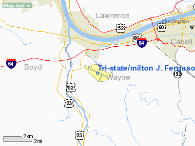
Tri-state/milton J. Ferguson Field Airport |
Tri-State Airport
Milton J. Ferguson Field |
 |
| IATA: HTS – ICAO: KHTS |
| Summary |
| Airport type |
Public |
| Operator |
Tri-State Airport Authority |
| Serves |
Huntington, West Virginia |
| Location |
Kenova, West Virginia |
| Elevation AMSL |
828 ft / 252.4 m |
| Coordinates |
38°22′00″N 82°33′29″W / 38.3666667°N 82.55806°W / 38.3666667; -82.55806Coordinates: 38°22′00″N 82°33′29″W / 38.3666667°N 82.55806°W / 38.3666667; -82.55806 |
| Runways |
| Direction |
Length |
Surface |
| ft |
m |
| 12/30 |
6,517 |
1,986 |
Asphalt |
| 3/21 |
3,007 |
917 |
Asphalt |
Tri-State Airport (IATA: HTS, ICAO: KHTS), also known as Milton J. Ferguson Field, is a public airport located just south of Ceredo, West Virginia, three miles (5 km) south of the central business district (CBD) of Huntington, West Virginia. It serves the nearby cities of Huntington, Ashland, Kentucky, and Ironton, Ohio. The airport has two runways, one at 6,517 feet, the other at 3,007 feet. It has heavy use for general aviation, but is also serviced by three commercial airlines. Incidents
- On November 14, 1970, a chartered Southern Airways DC-9 commercial jet crashed into a hill just short of Runway 12. The flight was carrying the thirty-seven members of the Marshall University "Thundering Herd" football squad, eight members of the coaching staff, and twenty-five boosters. There were no survivors.
- On the morning of August 5, 1987 a Piedmont Airlines Boeing 737-200 on a regularly scheduled flight struck deer after reaching V1 during the takeoff roll. One engine sustained damage and subsequently flamed out, and the aircraft immediately returned to the airport.
- On June 16, 1994, a Fokker F.28-4000 operated by USAIR suffered a hard landing after which the right main landing gear collapsed. The jet slid to a stop causing significant damage to the aircraft and the runway. There were minor injuries during the landing and evacuation. The aircraft was repaired after several weeks at Tri-State and re-entered service later that year.
- On January 8, 2003, Air Midwest Flight 5481 operating as US Airways Express Flight 5481 (N233YV), crashed at Charlotte-Douglas International Airport, killing all 21 aboard. It was determined that the accident was caused primarily by the faulty adjustment of an elevator cable - work that was performed just 2 days earlier at a facility at Tri-State Airport - by a mechanic that had never worked on that type of aircraft. [6]
- On August 17, 2006, Rima Qayyum, a woman of Pakistani origin residing within the US, was prevented from boarding a plane when it was found she had banned materials in her hand luggage. While these initially tested positive for explosive residue, subsequent analysis revealed that the liquids were harmless . Later testing revealed that it was just water and soap The woman had purchased a one-way ticket on a flight to Charlotte, North Carolina . In 2008, Qayyum filed a federal law suit against US Airways for violating her civil rights.
- On January 30, 2009, a Piper PA-34-200T Seneca crashed in the vicinity of KHTS during a significant snow event. The pilot was attempting to divert to KHTS due to a fuel emergency. All 6 aboard were killed.
Airlines and destinations
| Airlines |
Destinations |
| Allegiant Air |
Fort Lauderdale, Myrtle Beach, Orlando, St. Petersburg/Clearwater |
| Delta Connection operated by Comair |
Cincinnati/Northern Kentucky |
| US Airways Express operated by Piedmont Airlines |
Charlotte |
The above content comes from Wikipedia and is published under free licenses – click here to read more.
Location & QuickFacts
| FAA Information Effective: | 2008-09-25 |
| Airport Identifier: | HTS |
| Airport Status: | Operational |
| Longitude/Latitude: | 082-33-28.9000W/38-22-00.0000N
-82.558028/38.366667 (Estimated) |
| Elevation: | 828 ft / 252.37 m (Surveyed) |
| Land: | 1300 acres |
| From nearest city: | 3 nautical miles S of Huntington, WV |
| Location: | Wayne County, WV |
| Magnetic Variation: | 06W (1995) |
Owner & Manager
| Ownership: | Publicly owned |
| Owner: | Tri-state Airport Auth. |
| Address: | 1449 Airport Road
Huntington, WV 25704 |
| Phone number: | 304-453-6165 |
| Manager: | L G Salyers |
| Address: | 1449 Airport Road
Huntington, WV 25704 |
| Phone number: | 304-453-6165 |
Airport Operations and Facilities
| Airport Use: | Open to public |
| Wind indicator: | Yes |
| Segmented Circle: | No |
| Control Tower: | Yes |
| Lighting Schedule: | DUSK-DAWN |
| Beacon Color: | Clear-Green (lighted land airport) |
| Landing fee charge: | Yes
FEE FOR ACFT UNLESS GAS PURCHASED. |
| Sectional chart: | Cincinnati |
| Region: | AEA - Eastern |
| Boundary ARTCC: | ZID - Indianapolis |
| Tie-in FSS: | EKN - Elkins |
| FSS on Airport: | No |
| FSS Toll Free: | 1-800-WX-BRIEF |
| NOTAMs Facility: | HTS (NOTAM-d service avaliable) |
| Certification type/date: | I B S 05/1973 |
| Federal Agreements: | NGYH |
Airport Communications
Airport Services
| Fuel available: | 100LLA |
| Airframe Repair: | MAJOR |
| Power Plant Repair: | MAJOR |
| Bottled Oxygen: | HIGH/LOW |
| Bulk Oxygen: | NONE |
Runway Information
Runway 03/21
| Dimension: | 3007 x 60 ft / 916.5 x 18.3 m |
| Surface: | ASPH, Poor Condition
NUMEROUS LONGITUDINAL CRACKS IN PAVEMENT. |
| Weight Limit: | Single wheel: 12500 lbs. |
| Edge Lights: | Medium |
| |
Runway 03 |
Runway 21 |
| Longitude: | 082-33-24.0549W | 082-33-09.6908W |
| Latitude: | 38-21-33.9233N | 38-22-01.4097N |
| Elevation: | 828.00 ft | 827.00 ft |
| Alignment: | 22 | 127 |
| Traffic Pattern: | Left | Left |
| Markings: | Basic, Good Condition
RY 3/21 MARKINGS FADED | Basic, Good Condition
RY 3/21 MARKINGS FADED |
| Crossing Height: | 26.00 ft | 33.00 ft |
| VASI: | 2-light PAPI on left side | 2-light PAPI on left side |
| Visual Glide Angle: | 4.00° | 4.00° |
| Runway End Identifier: | No | No |
| Touchdown Lights: | No | No |
| Obstruction: | 28 ft trees, 500.0 ft from runway, 75 ft left of centerline, 10:1 slope to clear
+3 FT REFLECTORS 200 FT FM RY END ON CNTRLN. | 38 ft trees, 300.0 ft from runway, 200 ft left of centerline, 2:1 slope to clear
+2' GND 180' FROM RWY END. |
|
Runway 12/30
| Dimension: | 6517 x 150 ft / 1986.4 x 45.7 m |
| Surface: | ASPH, Good Condition
NUMEROUS LONGITUDINAL CRACKS IN PAVEMENT. |
| Surface Treatment: | Saw-cut or plastic Grooved |
| Weight Limit: | Single wheel: 110000 lbs.
Dual wheel: 140000 lbs.
Dual tandem wheel: 230000 lbs. |
| Edge Lights: | High |
| |
Runway 12 |
Runway 30 |
| Longitude: | 082-34-12.2044W | 082-32-56.5449W |
| Latitude: | 38-22-17.9353N | 38-21-53.4153N |
| Elevation: | 827.00 ft | 828.00 ft |
| Alignment: | 112 | 127 |
| ILS Type: | ILS
| ILS
|
| Traffic Pattern: | Left | Left |
| Markings: | Precision instrument, Good Condition
RWY MARKINGS FADED | Precision instrument, Good Condition
RWY MARKINGS FADED |
| Crossing Height: | 51.00 ft | 47.00 ft |
| VASI: | 4-light PAPI on left side | 4-light PAPI on left side |
| Visual Glide Angle: | 3.00° | 3.00° |
| RVR Equipment: | touchdown | |
| Approach lights: | MALSR | |
| Runway End Identifier: | No | Yes |
| Touchdown Lights: | No | No |
| Obstruction: | 36 ft trees, 950.0 ft from runway, 400 ft left of centerline, 21:1 slope to clear | , 50:1 slope to clear |
|
Radio Navigation Aids
| ID |
Type |
Name |
Ch |
Freq |
Var |
Dist |
| AJY | FAN MARKER | Ashland | | | 03W | 16.0 nm |
| PMH | NDB | Portsmouth | | 373.00 | 04W | 28.4 nm |
| GAS | NDB | Gallipolis | | 420.00 | 07W | 33.7 nm |
| GTC | NDB | Guyandot | | 293.00 | 03W | 46.7 nm |
| PZO | NDB | Peebles | | 329.00 | 02W | 49.1 nm |
| ECB | VORTAC | Newcombe | 041X | 110.40 | 02W | 20.8 nm |
| YRK | VORTAC | York | 075X | 112.80 | 05W | 25.9 nm |
| HNN | VORTAC | Henderson | 106X | 115.90 | 03W | 34.2 nm |
| HVQ | VORTAC | Charleston | 121X | 117.40 | 03W | 37.2 nm |
| CRW | VOT | Charleston Kanawha | | 108.80 | | 45.5 nm |
Remarks
- PILOTS REPORT POSSIBILITY OF MISTAKING FUEL BURNING STACK LCTD APRXLY 2 MI W RY 12 FOR APCH LGTG SFL.
- RY 12 OBSTN TWR LCTD 5100 FT W 600 FT N END RY.
- RY 03/21 CLSD TO ACR OPNS.
- BIRDS & DEER ON & INVOF ARPT.
- TWY "A" BTWN RY 21 & AER 30 RSTD TO ACFT WITH WINGSPAN OF 108 FT OR LESS; TWY "G" RSTD TO ACFT WITH WINGSPAN OF 142 FT OR LESS.
- GA APRON - NUMEROUS CRACKS, SPALLING & JOINT DETERIORATION.
- EXISTED PRIOR TO 1959.
Images and information placed above are from
http://www.airport-data.com/airport/HTS/
We thank them for the data!
| General Info
|
| Country |
United States
|
| State |
WEST VIRGINIA
|
| FAA ID |
HTS
|
| Latitude |
38-22-00.000N
|
| Longitude |
082-33-28.900W
|
| Elevation |
828 feet
|
| Near City |
HUNTINGTON
|
We don't guarantee the information is fresh and accurate. The data may
be wrong or outdated.
For more up-to-date information please refer to other sources.
|
|


