 |
|
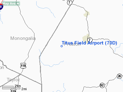
Location & QuickFacts
| FAA Information Effective: | 2008-09-25 |
| Airport Identifier: | 70D |
| Airport Status: | Operational |
| Longitude/Latitude: | 079-51-09.2240W/39-29-55.3070N
-79.852562/39.498696 (Estimated) |
| Elevation: | 1860 ft / 566.93 m (Estimated) |
| Land: | 200 acres |
| From nearest city: | 2 nautical miles W of Arthurdale, WV |
| Location: | Preston County, WV |
| Magnetic Variation: | 07W (1985) |
Owner & Manager
| Ownership: | Privately owned |
| Owner: | Jean Krasco |
| Address: | Rt 2, Box 110
Reedsville, WV 26547 |
| Phone number: | 304-864-6996 |
| Manager: | Jean Krasco |
| Address: | Rt 2 Box 110
Reedsville, WV 26547 |
| Phone number: | 304-864-6996 |
Airport Operations and Facilities
| Airport Use: | Open to public |
| Wind indicator: | No |
| Segmented Circle: | No |
| Control Tower: | No |
| Landing fee charge: | No |
| Sectional chart: | Cincinnati |
| Region: | AEA - Eastern |
| Boundary ARTCC: | ZOB - Cleveland |
| Tie-in FSS: | EKN - Elkins |
| FSS on Airport: | No |
| FSS Toll Free: | 1-800-WX-BRIEF |
| NOTAMs Facility: | EKN (NOTAM-d service avaliable) |
Airport Communications
Airport Services
| Airframe Repair: | NONE |
| Power Plant Repair: | NONE |
| Bottled Oxygen: | NONE |
| Bulk Oxygen: | NONE |
Runway Information
Runway 09/27
| Dimension: | 2400 x 50 ft / 731.5 x 15.2 m |
| Surface: | TURF, Poor Condition
SFC ROUGH & INFREQUENTLY MOWED; SOFT WHEN WET; LOOSE ROCK ON SURFACE. |
| |
Runway 09 |
Runway 27 |
| Traffic Pattern: | Left | Left |
| Obstruction: | 15 ft trees | 40 ft tree, 550.0 ft from runway, 100 ft left of centerline, 13:1 slope to clear |
|
Radio Navigation Aids
| ID |
Type |
Name |
Ch |
Freq |
Var |
Dist |
| VV | NDB | Camor | | 299.00 | 08W | 23.6 nm |
| RQY | NDB | Randolph County | | 284.00 | 07W | 36.4 nm |
| PNU | NDB | Washington County | | 255.00 | 08W | 41.4 nm |
| CKB | VOR/DME | Clarksburg | 073X | 112.60 | 04W | 24.3 nm |
| GRV | VOR/DME | Grantsville | 070X | 112.30 | 06W | 38.1 nm |
| ESL | VOR/DME | Kessel | 045X | 110.80 | 06W | 43.3 nm |
| AGC | VOR/DME | Allegheny | 037X | 110.00 | 09W | 47.7 nm |
| MGW | VORTAC | Morgantown | 053X | 111.60 | 05W | 3.5 nm |
| IHD | VORTAC | Indian Head | 019X | 108.20 | 06W | 36.6 nm |
| EKN | VORTAC | Elkins | 089X | 114.20 | 07W | 37.0 nm |
Remarks
- +25 FT TREES ALONG EDGE OF RY.
- DEER ON & INVOF RY.
- UNLIMITED VEHICLE ACCESS TO ARPT.
- RY 09/27 HAS POTENTIALLY HAZARDOUS SFC VARIATION IN RY SAFETY AREA.
- RY 27 HAS 8 FT DROPOFF 25 FT FM THLD 0B.
Images and information placed above are from
http://www.airport-data.com/airport/70D/
We thank them for the data!
| General Info
|
| Country |
United States
|
| State |
WEST VIRGINIA
|
| FAA ID |
70D
|
| Latitude |
39-29-55.307N
|
| Longitude |
079-51-09.224W
|
| Elevation |
1860 feet
|
| Near City |
ARTHURDALE
|
We don't guarantee the information is fresh and accurate. The data may
be wrong or outdated.
For more up-to-date information please refer to other sources.
|
|


