 |
|
Raleigh County Memorial Airport |
Coordinates: 37°47′14″N 081°07′27″W / 37.78722°N 81.12417°W / 37.78722; -81.12417
| Beckley Raleigh County Memorial Airport |
| IATA: BKW – ICAO: KBKW – FAA LID: BKW |
| Summary |
| Airport type |
Public |
| Owner |
Raleigh County Airport Authority |
| Serves |
Beckley, West Virginia |
| Elevation AMSL |
2,504 ft / 763 m |
| Website |
www.FlyBeckley.com |
| Runways |
| Direction |
Length |
Surface |
| ft |
m |
| 1/19 |
6,750 |
2,057 |
Asphalt |
| 10/28 |
5,000 |
1,524 |
Asphalt |
| Statistics (2006) |
| Aircraft operations |
10,110 |
| Sources: airport web site and FAA |
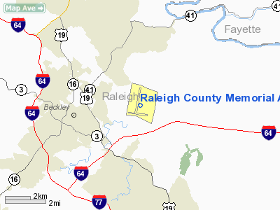
Beckley Raleigh County Memorial Airport (IATA: BKW, ICAO: KBKW, FAA LID: BKW), also known as Raleigh County Memorial Airport, is a public airport located three miles (5 km) east of the central business district of Beckley, a city in Raleigh County, West Virginia, United States. It is owned by the Raleigh County Airport Authority.
The airport is often used for general aviation, but is also served by two commercial airlines. Service is subsidized by the Essential Air Service program. In 2006, the airport had the dubious honor of being the least busy airport with scheduled airline service in the United States, with 2,578 passengers using the facility. Facilities and aircraft
Raleigh County Memorial Airport covers an area of 1,433 acres (580 ha) which contains two asphalt paved runways: 1/19 measuring 6,750 x 150 ft (2,057 x 46 m) and 10/28 measuring 5,000 x 100 ft (1,524 x 30 m). For the 12-month period ending December 31, 2006, the airport had 10,110 aircraft operations, an average of 27 per day: 79% general aviation, 18% air taxi and 2% military.
Airline and destinations
| Airlines |
Destinations |
| Locair |
Baltimore |
| United Express operated by Colgan Air |
Shenandoah Valley/Staunton, Washington-Dulles |
The above content comes from Wikipedia and is published under free licenses – click here to read more.
Location & QuickFacts
| FAA Information Effective: | 2008-09-25 |
| Airport Identifier: | BKW |
| Airport Status: | Operational |
| Longitude/Latitude: | 081-07-26.9914W/37-47-14.3754N
-81.124164/37.787326 (Estimated) |
| Elevation: | 2504 ft / 763.22 m (Surveyed) |
| Land: | 1433 acres |
| From nearest city: | 3 nautical miles E of Beckley, WV |
| Location: | Raleigh County, WV |
| Magnetic Variation: | 06W (1985) |
Owner & Manager
| Ownership: | Publicly owned |
| Owner: | Raleigh County Arpt Auth |
| Address: | 176 Airport Circle Rm 105
Beaver, WV 25813 |
| Phone number: | 304-255-0476 |
| Manager: | Tom Cochran |
| Address: | 176 Airport Circle Rm 105
Beaver, WV 25813 |
| Phone number: | 304-255-0476 |
Airport Operations and Facilities
| Airport Use: | Open to public |
| Wind indicator: | Yes |
| Segmented Circle: | No |
| Control Tower: | No |
| Lighting Schedule: | DUSK-DAWN
ACTVT MIRL RY 10/28; HIRL RY 01/19; MALSR RY 19; REIL RYS 01 & 10 & 28; VASI RY 10 & TWY LGTS - CTAF. |
| Beacon Color: | Clear-Green (lighted land airport) |
| Landing fee charge: | No |
| Sectional chart: | Cincinnati |
| Region: | AEA - Eastern |
| Boundary ARTCC: | ZID - Indianapolis |
| Tie-in FSS: | EKN - Elkins |
| FSS on Airport: | No |
| FSS Toll Free: | 1-800-WX-BRIEF |
| NOTAMs Facility: | BKW (NOTAM-d service avaliable) |
| Certification type/date: | I A S 05/1973
PPR 24 HRS FOR UNSKED ACR OPNS WITH MORE THAN 30 PSGR SEATS; CALL AMGR 304-255-0476. |
| Federal Agreements: | NGY |
Airport Communications
| CTAF: | 123.000 |
| Unicom: | 123.000 |
Airport Services
| Fuel available: | 100LLA |
| Airframe Repair: | MAJOR |
| Power Plant Repair: | MAJOR |
| Bottled Oxygen: | NONE |
| Bulk Oxygen: | NONE |
Runway Information
Runway 01/19
| Dimension: | 6750 x 150 ft / 2057.4 x 45.7 m |
| Surface: | ASPH, Good Condition |
| Surface Treatment: | Saw-cut or plastic Grooved |
| Weight Limit: | Single wheel: 75000 lbs.
Dual wheel: 150000 lbs.
Dual tandem wheel: 200000 lbs. |
| Edge Lights: | High |
| |
Runway 01 |
Runway 19 |
| Longitude: | 081-07-32.7997W | 081-07-21.8414W |
| Latitude: | 37-46-55.4374N | 37-48-01.5910N |
| Elevation: | 2495.00 ft | 2449.00 ft |
| Alignment: | 7 | 127 |
| ILS Type: | | ILS
|
| Traffic Pattern: | Left | Left |
| Markings: | Non-precision instrument, Fair Condition | Precision instrument, Fair Condition |
| Crossing Height: | 40.00 ft | 55.00 ft |
| VASI: | 4-box on left side | 4-box on left side |
| Visual Glide Angle: | 3.00° | 3.00° |
| Approach lights: | | MALSR |
| Runway End Identifier: | Yes | |
| Obstruction: | 85 ft trees, 1775.0 ft from runway, 620 ft right of centerline, 18:1 slope to clear | , 50:1 slope to clear |
|
Runway 10/28
| Dimension: | 5000 x 100 ft / 1524.0 x 30.5 m |
| Surface: | ASPH, Good Condition |
| Weight Limit: | Single wheel: 45000 lbs.
Dual wheel: 60000 lbs. |
| Edge Lights: | Medium |
| |
Runway 10 |
Runway 28 |
| Longitude: | 081-07-57.4167W | 081-06-55.6763W |
| Latitude: | 37-46-58.5230N | 37-46-52.0523N |
| Elevation: | 2486.00 ft | 2501.00 ft |
| Alignment: | 97 | 127 |
| Traffic Pattern: | Left | Left |
| Markings: | Non-precision instrument, Good Condition
RY 10/28 MKGS FADED. | Basic, Good Condition
RWY 28 MARKINGS POOR |
| Crossing Height: | 51.00 ft | 66.00 ft |
| VASI: | 4-box on right side | 4-box on left side |
| Visual Glide Angle: | 3.00° | 3.25° |
| Runway End Identifier: | Yes | Yes |
| Obstruction: | , 50:1 slope to clear | 122 ft trees, 2060.0 ft from runway, 179 ft left of centerline, 15:1 slope to clear
9' POLE, 125' OUT, 250' RT SIDE |
|
Radio Navigation Aids
| ID |
Type |
Name |
Ch |
Freq |
Var |
Dist |
| IJZ | NDB | Nicholas | | 272.00 | 05W | 25.2 nm |
| LW | NDB | Bushi | | 346.00 | 06W | 31.2 nm |
| GTC | NDB | Guyandot | | 293.00 | 03W | 37.3 nm |
| TEC | NDB | Tech | | 368.00 | 06W | 48.9 nm |
| RNL | VOR | Rainelle | | 116.60 | 04W | 18.8 nm |
| LWB | VOR/DME | Greenbrier | 107Y | 116.05 | 08W | 35.1 nm |
| BKW | VORTAC | Beckley | 124X | 117.70 | 06W | 0.4 nm |
| BLF | VORTAC | Bluefield | 037X | 110.00 | 03W | 29.1 nm |
| HVQ | VORTAC | Charleston | 121X | 117.40 | 03W | 45.6 nm |
| PSK | VORTAC | Pulaski | 115X | 116.80 | 06W | 46.4 nm |
| CRW | VOT | Charleston Kanawha | | 108.80 | | 41.6 nm |
Remarks
- DEER; BIRDS & WILD TURKEYS ON & INVOF ARPT.
- ESTAB PRIOR TO 1959
Images and information placed above are from
http://www.airport-data.com/airport/BKW/
We thank them for the data!
| General Info
|
| Country |
United States
|
| State |
WEST VIRGINIA
|
| FAA ID |
BKW
|
| Latitude |
37-47-14.382N
|
| Longitude |
081-07-26.991W
|
| Elevation |
2504 feet
|
| Near City |
BECKLEY
|
We don't guarantee the information is fresh and accurate. The data may
be wrong or outdated.
For more up-to-date information please refer to other sources.
|
|


