|
|
Coordinates: 39°52′51″N 080°44′09″W / 39.88083°N 80.73583°W / 39.88083; -80.73583
| Marshall County Airport |
 |
| IATA: none – ICAO: KMPG – FAA LID: MPG |
| Summary |
| Airport type |
Public |
| Owner |
Marshall County Commission |
| Serves |
Moundsville, West Virginia |
| Elevation AMSL |
1,214 ft / 370 m |
| Runways |
| Direction |
Length |
Surface |
| ft |
m |
| 6/24 |
3,302 |
1,006 |
Asphalt |
| Statistics (2006) |
| Aircraft operations |
19,300 |
| Source: Federal Aviation Administration |
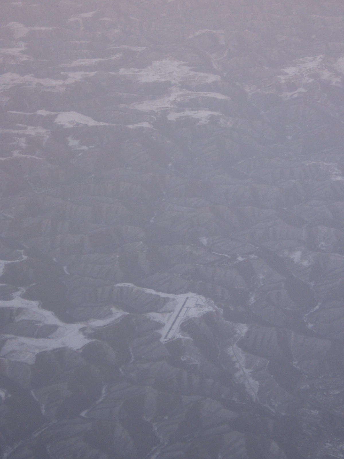
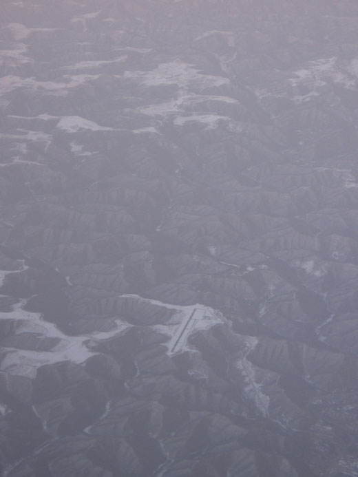
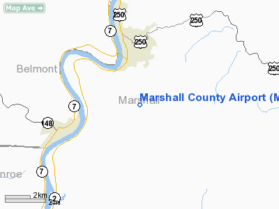
Marshall County Airport (ICAO: KMPG, FAA LID: MPG, formerly 74D) is a public airport located three miles (5 km) south of the central business district of Moundsville, a city in Marshall County, West Virginia, United States. The airport is owned by the Marshall County Commission.
Although most U.S. airports use the same three-letter location identifier for the FAA and IATA, Marshall County Airport is assigned MPG by the FAA but has no designation from the IATA (which assigned MPG to Makini, Papua New Guinea).
Facilities and aircraft
Marshall County Airport covers an area of 96 acres (39 ha) which contains one runway designated 6/24 with a 3,302 x 60 ft (1,006 x 18 m) asphalt surface. Situated in rugged mountain terrain, the airport site is a removed mountaintop with steep slopes to all sides. For the 12-month period ending December 31, 2006, the airport had 19,300 aircraft operations, an average of 52 per day: 97% general aviation, 3% military and <1% air taxi.
The above content comes from Wikipedia and is published under free licenses – click here to read more.
Location & QuickFacts
| FAA Information Effective: | 2008-09-25 |
| Airport Identifier: | MPG |
| Airport Status: | Operational |
| Longitude/Latitude: | 080-44-08.8000W/39-52-51.0000N
-80.735778/39.880833 (Estimated) |
| Elevation: | 1214 ft / 370.03 m (Surveyed) |
| Land: | 96 acres |
| From nearest city: | 3 nautical miles S of Moundsville, WV |
| Location: | Marshall County, WV |
| Magnetic Variation: | 08W (2000) |
Owner & Manager
| Ownership: | Publicly owned |
| Owner: | Marshall Co Comsn |
| Address: | County Court House
Moundsville, WV 26041 |
| Phone number: | 304-845-1220 |
| Manager: | Susan Board |
| Address: | Rd 2 Box 322a
Moundsville, WV 26041 |
| Phone number: | 304-845-0200
AND 304-845-7702 |
Airport Operations and Facilities
| Airport Use: | Open to public |
| Wind indicator: | Yes |
| Segmented Circle: | Yes |
| Control Tower: | No |
| Lighting Schedule: | DUSK-DAWN
ACTVT MIRL RY 06/24 - CTAF. PAPI RYS 06 & 24 OPER CONT. |
| Beacon Color: | Clear-Green (lighted land airport) |
| Landing fee charge: | No |
| Sectional chart: | Cincinnati |
| Region: | AEA - Eastern |
| Boundary ARTCC: | ZOB - Cleveland |
| Tie-in FSS: | EKN - Elkins |
| FSS on Airport: | No |
| FSS Toll Free: | 1-800-WX-BRIEF |
| NOTAMs Facility: | EKN (NOTAM-d service avaliable) |
| Federal Agreements: | NGY |
Airport Communications
| CTAF: | 122.700 |
| Unicom: | 122.700 |
Airport Services
| Fuel available: | 100LL |
| Airframe Repair: | MINOR |
| Power Plant Repair: | MINOR |
| Bottled Oxygen: | NONE |
| Bulk Oxygen: | NONE |
Runway Information
Runway 06/24
| Dimension: | 3302 x 60 ft / 1006.4 x 18.3 m |
| Surface: | ASPH, Fair Condition |
| Weight Limit: | Single wheel: 12500 lbs. |
| Edge Lights: | Medium |
| |
Runway 06 |
Runway 24 |
| Longitude: | 080-44-25.3950W | 080-43-52.1830W |
| Latitude: | 39-52-40.8320N | 39-53-01.0760N |
| Elevation: | 1214.00 ft | 1194.00 ft |
| Alignment: | 52 | 127 |
| Traffic Pattern: | Left | Left |
| Markings: | Non-precision instrument, Poor Condition
RY MARKINGS FADED. | Non-precision instrument, Poor Condition
RY MARKINGS FADED. |
| Crossing Height: | 26.00 ft | 40.00 ft |
| VASI: | 2-light PAPI on right side | 2-light PAPI on right side
RY 24 PAPI MAY BE PARTIALLY OBSCURED BY BRUSH. |
| Visual Glide Angle: | 4.00° | 3.00° |
| Obstruction: | 245 ft tower, 5100.0 ft from runway, 350 ft left of centerline, 20:1 slope to clear | 40 ft trees, 200.0 ft from runway, 75 ft right of centerline
25 FT BRUSH 20-200 FT FM THLD 90 FT L; 15 FT BRUSH 100-200 FT FM THLD 90 FT R. |
|
Radio Navigation Aids
| ID |
Type |
Name |
Ch |
Freq |
Var |
Dist |
| PKB | FAN MARKER | Marietta Ohio | | | 03W | 43.3 nm |
| CFX | NDB | Cadiz | | 239.00 | 07W | 24.9 nm |
| PNU | NDB | Washington County | | 255.00 | 08W | 30.8 nm |
| TSO | NDB | Tolson | | 395.00 | 07W | 43.9 nm |
| VV | NDB | Camor | | 299.00 | 08W | 45.7 nm |
| AIR | VOR/DME | Bellaire | 118X | 117.10 | 07W | 9.0 nm |
| HLG | VOR/DME | Wheeling | 059X | 112.20 | 07W | 24.0 nm |
| AGC | VOR/DME | Allegheny | 037X | 110.00 | 09W | 39.9 nm |
| CTW | VOR/DME | Newcomerstown | 055X | 111.80 | 07W | 40.0 nm |
| CKB | VOR/DME | Clarksburg | 073X | 112.60 | 04W | 43.5 nm |
| JPU | VORTAC | Parkersburg | 023X | 108.60 | 03W | 39.7 nm |
| MMJ | VORTAC | Montour | 057X | 112.00 | 08W | 44.2 nm |
| MGW | VORTAC | Morgantown | 053X | 111.60 | 05W | 44.9 nm |
Remarks
- DEER & BIRDS ON & INVOF APT.
- RY 24 HAS .6% UPHILL GRADIENT.
- RY SAFETY AREA BOTH ENDS HAVE 100 FT DROPOFFS 200 FT FM THLD 0B.
Images and information placed above are from
http://www.airport-data.com/airport/MPG/
We thank them for the data!
|
|