 |
|
Location & QuickFacts
| FAA Information Effective: | 2008-09-25 |
| Airport Identifier: | WV03 |
| Airport Status: | Operational |
| Longitude/Latitude: | 081-06-59.3520W/37-47-00.4150N
-81.116487/37.783449 (Estimated) |
| Elevation: | 2180 ft / 664.46 m (Estimated) |
| Land: | 0 acres |
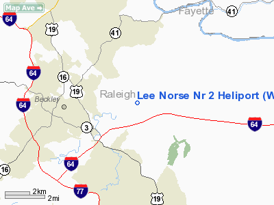
| From nearest city: | 4 nautical miles SE of Beckley, WV |
| Location: | Raleigh County, WV |
| Magnetic Variation: | 06W (1985) |
Owner & Manager
| Ownership: | Privately owned |
| Owner: | Ingersoll-rand Co. |
| Address: | 4201 Lee Highway
Bristol, VA 24201 |
| Phone number: | 703-699-9171 |
| Manager: | Pilot |
| Address: | 4201 Lee Highway
Bristol, VA 24201 |
| Phone number: | 703-669-9171 |
Airport Operations and Facilities
| Airport Use: | Private |
| Wind indicator: | Yes |
| Segmented Circle: | No |
| Control Tower: | No |
| Sectional chart: | Cincinnati |
| Region: | AEA - Eastern |
| Boundary ARTCC: | ZID - Indianapolis |
| Tie-in FSS: | EKN - Elkins |
| FSS on Airport: | No |
| FSS Toll Free: | 1-800-WX-BRIEF |
Runway Information
Helipad H1
| Dimension: | 100 x 100 ft / 30.5 x 30.5 m |
| Surface: | TURF, |
| |
Runway H1 |
Runway |
| Traffic Pattern: | Left | Left |
|
Radio Navigation Aids
| ID |
Type |
Name |
Ch |
Freq |
Var |
Dist |
| IJZ | NDB | Nicholas | | 272.00 | 05W | 25.3 nm |
| LW | NDB | Bushi | | 346.00 | 06W | 30.8 nm |
| GTC | NDB | Guyandot | | 293.00 | 03W | 37.6 nm |
| TEC | NDB | Tech | | 368.00 | 06W | 48.5 nm |
| RNL | VOR | Rainelle | | 116.60 | 04W | 18.7 nm |
| LWB | VOR/DME | Greenbrier | 107Y | 116.05 | 08W | 34.7 nm |
| BKW | VORTAC | Beckley | 124X | 117.70 | 06W | 0.4 nm |
| BLF | VORTAC | Bluefield | 037X | 110.00 | 03W | 28.9 nm |
| HVQ | VORTAC | Charleston | 121X | 117.40 | 03W | 46.0 nm |
| PSK | VORTAC | Pulaski | 115X | 116.80 | 06W | 46.0 nm |
| CRW | VOT | Charleston Kanawha | | 108.80 | | 42.0 nm |
Images and information placed above are from
http://www.airport-data.com/airport/WV03/
We thank them for the data!
| General Info
|
| Country |
United States
|
| State |
WEST VIRGINIA
|
| FAA ID |
WV03
|
| Latitude |
37-47-00.415N
|
| Longitude |
081-06-59.352W
|
| Elevation |
2180 feet
|
| Near City |
BECKLEY
|
We don't guarantee the information is fresh and accurate. The data may
be wrong or outdated.
For more up-to-date information please refer to other sources.
|
|


