 |
|
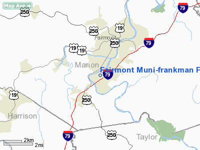
Fairmont Muni-frankman Field Airport |
Location & QuickFacts
| FAA Information Effective: | 2008-09-25 |
| Airport Identifier: | 4G7 |
| Airport Status: | Operational |
| Longitude/Latitude: | 080-10-01.3000W/39-26-53.4000N
-80.167028/39.448167 (Estimated) |
| Elevation: | 1029 ft / 313.64 m (Surveyed) |
| Land: | 20 acres |
| From nearest city: | 2 nautical miles SW of Fairmont, WV |
| Location: | Marion County, WV |
| Magnetic Variation: | 08W (2000) |
Owner & Manager
| Ownership: | Publicly owned |
| Owner: | Fairmont-marion Co Reg Arpt Auth |
| Address: | R #8 Box 343
Fairmont, WV 26554-0387 |
| Phone number: | 304-363-9432 |
| Manager: | Don Tucker |
| Address: | Po Box 387
Fairmont, WV 26555 |
| Phone number: | 304-366-1300
FBO PHONE NUMBER (304) 363-1468. |
Airport Operations and Facilities
| Airport Use: | Open to public |
| Wind indicator: | Yes |
| Segmented Circle: | No |
| Control Tower: | No |
| Lighting Schedule: | DUSK-DAWN
ACTVT NSTD LIRL RY 04/22, REIL RY 22, & VASI RY 22 - CTAF. |
| Beacon Color: | Clear-Green (lighted land airport) |
| Landing fee charge: | No |
| Sectional chart: | Cincinnati |
| Region: | AEA - Eastern |
| Boundary ARTCC: | ZOB - Cleveland |
| Tie-in FSS: | EKN - Elkins |
| FSS on Airport: | No |
| FSS Toll Free: | 1-800-WX-BRIEF |
| NOTAMs Facility: | EKN (NOTAM-d service avaliable) |
| Federal Agreements: | N |
Airport Communications
| CTAF: | 122.800 |
| Unicom: | 122.800 |
Airport Services
| Fuel available: | 100LL |
| Airframe Repair: | MAJOR |
| Power Plant Repair: | MAJOR |
| Bottled Oxygen: | NONE |
| Bulk Oxygen: | NONE |
Runway Information
Runway 04/22
| Dimension: | 2859 x 75 ft / 871.4 x 22.9 m |
| Surface: | ASPH, Good Condition |
| Weight Limit: | Single wheel: 12500 lbs. |
| Edge Lights: | Non-standard lighting system
NSTD LIRL FIRST 200 FT RY 04 NOT LGTD. |
| |
Runway 04 |
Runway 22 |
| Longitude: | 080-10-12.3426W | 080-09-50.2488W |
| Latitude: | 39-26-42.1383N | 39-27-04.6046N |
| Elevation: | 1029.00 ft | 1009.00 ft |
| Alignment: | 37 | 127 |
| Traffic Pattern: | Left | Left |
| Markings: | Basic, Good Condition
RY 04-22 NSTD MARKING NUMBERS SMALLER THAN RECOMMEDNED. | Basic, Poor Condition
MARKINGS FADED. |
| Crossing Height: | 0.00 ft | 40.00 ft |
| Displaced threshold: | 851.00 ft | 0.00 ft |
| VASI: | | 2-box SAVASI on left side |
| Visual Glide Angle: | 0.00° | 3.00° |
| Runway End Identifier: | | Yes |
| Obstruction: | 80 ft tree, 200.0 ft from runway, 220 ft right of centerline
+6 FT BRUSH AT DSPLCD THLD 40 FT L 0:1 TO DSPLCD THLD.
+30 FT TREES 700 FT FM THLD 0B; +70 FT TREES 160 FT FM THLD 140 FT R & L. | 40 ft trees, 200.0 ft from runway, 180 ft left of centerline
15 FT TREE 5 FT FM THLD 120 FT R. |
|
Radio Navigation Aids
| ID |
Type |
Name |
Ch |
Freq |
Var |
Dist |
| VV | NDB | Camor | | 299.00 | 08W | 32.6 nm |
| RQY | NDB | Randolph County | | 284.00 | 07W | 36.3 nm |
| PNU | NDB | Washington County | | 255.00 | 08W | 41.9 nm |
| CKB | VOR/DME | Clarksburg | 073X | 112.60 | 04W | 12.6 nm |
| AIR | VOR/DME | Bellaire | 118X | 117.10 | 07W | 45.5 nm |
| MGW | VORTAC | Morgantown | 053X | 111.60 | 05W | 15.6 nm |
| EKN | VORTAC | Elkins | 089X | 114.20 | 07W | 32.2 nm |
| IHD | VORTAC | Indian Head | 019X | 108.20 | 06W | 49.0 nm |
Remarks
- RADIO TOWERS APRX 300' AGL 2 MILES NE AND 2.5 MILES NW OF ARPT.
- DEER ON & INVOF ARPT.
- PARALLEL TWY CLSD INDEFLY.
- RY 04 CLSD FOR NIGHT LNDG INDEFLY.
- FEW BROKEN RUNWAY AND TAXIWAY LIGHTS.
Images and information placed above are from
http://www.airport-data.com/airport/4G7/
We thank them for the data!
| General Info
|
| Country |
United States
|
| State |
WEST VIRGINIA
|
| FAA ID |
4G7
|
| Latitude |
39-26-53.400N
|
| Longitude |
080-10-01.300W
|
| Elevation |
1029 feet
|
| Near City |
FAIRMONT
|
We don't guarantee the information is fresh and accurate. The data may
be wrong or outdated.
For more up-to-date information please refer to other sources.
|
|


