 |
|
Location & QuickFacts
| FAA Information Effective: | 2008-09-25 |
| Airport Identifier: | 23WV |
| Airport Status: | Operational |
| Longitude/Latitude: | 080-58-58.0000W/38-01-33.0000N
-80.982778/38.025833 (Estimated) |
| Elevation: | 2501 ft / 762.30 m (Estimated) |
| Land: | 0 acres |
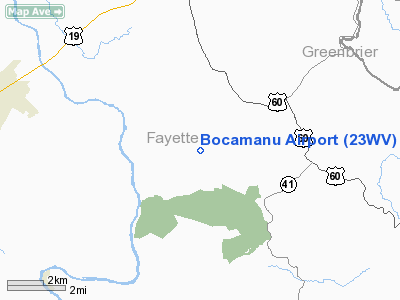
| From nearest city: | 7 nautical miles ES of Fayetteville, WV |
| Location: | Fayette County, WV |
| Magnetic Variation: | () |
Owner & Manager
| Ownership: | Privately owned |
| Owner: | Charles Garrison |
| Address: | 7017 S. North Shore Drive
Knoxville, TN 37919 |
| Phone number: | 865-805-4549 |
| Manager: | Charles Garrison |
| Address: | 7017 S. North Shore Drive
Knoxville, TN 37919 |
| Phone number: | 865-805-4549 |
Airport Operations and Facilities
| Airport Use: | Private |
| Control Tower: | No |
| Sectional chart: | Washington |
| Region: | AEA - Eastern |
| Boundary ARTCC: | ZID - Indianapolis |
| Tie-in FSS: | EKN - Elkins |
| FSS Toll Free: | 1-800-WX-BRIEF |
Runway Information
Runway 08/26
| Dimension: | 1600 x 250 ft / 487.7 x 76.2 m |
| Surface: | TURF, |
| |
Runway 08 |
Runway 26 |
| Traffic Pattern: | Left | Left |
|
Radio Navigation Aids
| ID |
Type |
Name |
Ch |
Freq |
Var |
Dist |
| IJZ | NDB | Nicholas | | 272.00 | 05W | 9.4 nm |
| LW | NDB | Bushi | | 346.00 | 06W | 28.5 nm |
| JTM | NDB | Braxton | | 234.00 | 06W | 42.6 nm |
| GTC | NDB | Guyandot | | 293.00 | 03W | 46.3 nm |
| RNL | VOR | Rainelle | | 116.60 | 04W | 8.9 nm |
| LWB | VOR/DME | Greenbrier | 107Y | 116.05 | 08W | 29.6 nm |
| BKW | VORTAC | Beckley | 124X | 117.70 | 06W | 16.2 nm |
| HVQ | VORTAC | Charleston | 121X | 117.40 | 03W | 42.0 nm |
| BLF | VORTAC | Bluefield | 037X | 110.00 | 03W | 44.4 nm |
| CRW | VOT | Charleston Kanawha | | 108.80 | | 35.6 nm |
Remarks
Images and information placed above are from
http://www.airport-data.com/airport/23WV/
We thank them for the data!
|
|


