 |
|
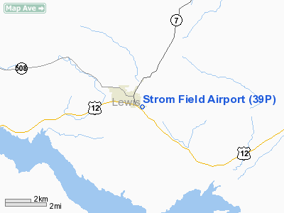
Location & QuickFacts
| FAA Information Effective: | 2008-09-25 |
| Airport Identifier: | 39P |
| Airport Status: | Operational |
| Longitude/Latitude: | 122-15-59.8530W/46-33-01.2990N
-122.266626/46.550361 (Estimated) |
| Elevation: | 941 ft / 286.82 m (Estimated) |
| Land: | 13 acres |
| From nearest city: | 0 nautical miles SE of Morton, WA |
| Location: | Lewis County, WA |
| Magnetic Variation: | 20E (1985) |
Owner & Manager
| Ownership: | Publicly owned |
| Owner: | City Of Morton |
| Address: | Po Box 1089
Morton, WA 98356 |
| Phone number: | 360-496-6881 |
| Manager: | Mayor James Gerwig
PUB. WKS. SUP. |
| Address: | , Po Box 1089
Morton, WA 98356 |
| Phone number: | 360-496-6881 |
Airport Operations and Facilities
| Airport Use: | Open to public |
| Wind indicator: | Yes |
| Segmented Circle: | No |
| Control Tower: | No |
| Lighting Schedule: | RDO-CTL
ACTVT ROTG BCN - CTAF. |
| Beacon Color: | Clear-Green (lighted land airport) |
| Landing fee charge: | No |
| Sectional chart: | Seattle |
| Region: | ANM - Northwest Mountain |
| Boundary ARTCC: | ZSE - Seattle |
| Tie-in FSS: | SEA - Seattle |
| FSS on Airport: | No |
| FSS Toll Free: | 1-800-WX-BRIEF |
| NOTAMs Facility: | SEA (NOTAM-d service avaliable) |
Airport Communications
Airport Services
| Airframe Repair: | NONE |
| Power Plant Repair: | NONE |
Runway Information
Runway 07/25
| Dimension: | 1810 x 40 ft / 551.7 x 12.2 m |
| Surface: | ASPH, Good Condition |
| Edge Lights: | Medium |
| |
Runway 07 |
Runway 25 |
| Longitude: | 122-16-12.8020W | 122-15-46.9040W |
| Latitude: | 46-33-01.3370N | 46-33-01.2600N |
| Alignment: | 90 | 127 |
| Traffic Pattern: | Left | Left |
| Markings: | Basic, Good Condition | Basic, Good Condition |
| Displaced threshold: | 200.00 ft | 0.00 ft |
| Obstruction: | 59 ft trees, 285.0 ft from runway, 3 ft right of centerline, 1:1 slope to clear
APCH SLOPE 8:1 TO DSPLCD THLD.
+3 FT ROAD AT 15 FT FM THLD. | 41 ft trees, 1318.0 ft from runway, 40 ft left of centerline, 27:1 slope to clear
RWY 25 +2 FT ROAD AT 15 FT FM THLD. |
|
Radio Navigation Aids
| ID |
Type |
Name |
Ch |
Freq |
Var |
Dist |
| TDO | NDB | Toledo | | 219.00 | 20E | 23.2 nm |
| LAC | NDB | Lacomas | | 328.00 | 18E | 30.0 nm |
| LSO | NDB | Kelso | | 256.00 | 21E | 35.8 nm |
| GR | NDB | Graye | | 216.00 | 18E | 38.6 nm |
| ODD | NDB | Dondo | | 224.00 | 19E | 48.9 nm |
| OLM | VORTAC | Olympia | 081X | 113.40 | 19E | 36.4 nm |
| TCM | VORTAC | Mcchord | 033X | 109.60 | 22E | 36.9 nm |
Remarks
- TREES NEAR RWY.
- TREES AND BRUSH IN PRIM SFC.
- DEER AND ELK ON & INVOF RWY.
- PRVDD PLINES REMOVED OR RELCTD.
Images and information placed above are from
http://www.airport-data.com/airport/39P/
We thank them for the data!
| General Info
|
| Country |
United States
|
| State |
WASHINGTON
|
| FAA ID |
39P
|
| Latitude |
46-33-01.392N
|
| Longitude |
122-15-59.375W
|
| Elevation |
950 feet
|
| Near City |
MORTON
|
We don't guarantee the information is fresh and accurate. The data may
be wrong or outdated.
For more up-to-date information please refer to other sources.
|
|


