 |
|
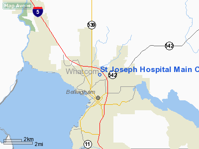
St Joseph Hospital Main Campus Heliport |
Location & QuickFacts
| FAA Information Effective: | 2008-09-25 |
| Airport Identifier: | WN73 |
| Airport Status: | Operational |
| Longitude/Latitude: | 122-28-25.6060W/48-46-29.3930N
-122.473779/48.774831 (Estimated) |
| Elevation: | 157 ft / 47.85 m (Estimated) |
| Land: | 1 acres |
| From nearest city: | 0 nautical miles S of Bellingham, WA |
| Location: | Whatcom County, WA |
| Magnetic Variation: | 21E (1985) |
Owner & Manager
| Ownership: | Privately owned |
| Owner: | St Joseph Hospital |
| Address: | 2901 Squalicum Prkwy
Bellingham, WA 98225 |
| Phone number: | 360-734-5400 |
| Manager: | Hermon Dew
DIRECTOR OF FACILITIES. |
| Address: | 2901 Squalicum Prkwy
Bellingham, WA 98225 |
| Phone number: | 360-788-6718 |
Airport Operations and Facilities
| Airport Use: | Private
MEDICAL USE. |
| Wind indicator: | Yes |
| Segmented Circle: | No |
| Control Tower: | No |
| Lighting Schedule: | 24 HRS |
| Landing fee charge: | No |
| Sectional chart: | Seattle |
| Region: | ANM - Northwest Mountain |
| Boundary ARTCC: | ZSE - Seattle |
| Tie-in FSS: | SEA - Seattle |
| FSS Toll Free: | 1-800-WX-BRIEF |
Runway Information
Helipad H1
| Dimension: | 72 x 72 ft / 21.9 x 21.9 m |
| Surface: | ASPH-CONC, |
| |
Runway H1 |
Runway |
| Traffic Pattern: | Left | Left |
|
Radio Navigation Aids
| ID |
Type |
Name |
Ch |
Freq |
Var |
Dist |
| XX | NDB | Abbotsford | | 344.00 | 21E | 14.5 nm |
| WC | NDB | White Rock | | 332.00 | 21E | 17.1 nm |
| BVS | NDB | Skagit/bay View | | 240.00 | 21E | 18.5 nm |
| LU | NDB | Cultus | | 214.00 | 22E | 22.4 nm |
| OPZ | NDB | Lopez Island | | 356.00 | 21E | 25.1 nm |
| FHR | NDB | Friday Harbor | | 284.00 | 20E | 26.6 nm |
| AP | NDB | Active Pass | | 378.00 | 21E | 32.8 nm |
| VR | NDB | Vancouver | | 266.00 | 21E | 33.2 nm |
| YJ | NDB | Victoria | | 200.00 | 21E | 37.5 nm |
| V | NDB | Victor | | 368.00 | 22E | 38.6 nm |
| MB | NDB | Mill Bay | | 293.00 | 21E | 42.6 nm |
| NUW | TACAN | Whidbey Island | 085X | | 21E | 26.3 nm |
| CVV | VOR/DME | Penn Cove | 119X | 117.20 | 19E | 33.4 nm |
| YYJ | VOR/DME | Victoria | 084X | 113.70 | 21E | 40.2 nm |
| HUH | VORTAC | Whatcom | 077X | 113.00 | 20E | 11.1 nm |
| YVR | VORTAC | Vancouver | 44 | 115.90 | 21E | 32.3 nm |
Remarks
- NOISE ABATEMENT PROCEDURES IN EFFECT. CALL 206-738-6356 & ASK FOR ON-DUTY PILOT.
Images and information placed above are from
http://www.airport-data.com/airport/WN73/
We thank them for the data!
| General Info
|
| Country |
United States
|
| State |
WASHINGTON
|
| FAA ID |
WN73
|
| Latitude |
48-46-29.393N
|
| Longitude |
122-28-25.606W
|
| Elevation |
157 feet
|
| Near City |
BELLINGHAM
|
We don't guarantee the information is fresh and accurate. The data may
be wrong or outdated.
For more up-to-date information please refer to other sources.
|
|


