 |
|
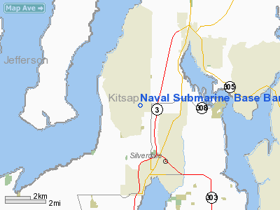
Naval Submarine Base Bangor Heliport |
Location & QuickFacts
| FAA Information Effective: | 2008-09-25 |
| Airport Identifier: | 9WA9 |
| Airport Status: | Operational |
| Longitude/Latitude: | 122-42-13.5460W/47-41-59.3380N
-122.703763/47.699816 (Estimated) |
| Elevation: | 285 ft / 86.87 m (Estimated) |
| Land: | 0 acres |
| From nearest city: | 3 nautical miles S of Silverdale, WA |
| Location: | Kitsap County, WA |
| Magnetic Variation: | 21E (1985) |
Owner & Manager
| Ownership: | Navy owned |
| Owner: | U S Navy |
| Address: | Naval Submarine Base Bangor
Bremerton, WA 98315 |
| Phone number: | 206-396-4864 |
| Manager: | Commanding Officer |
| Address: | Naval Submarine Base Bangor
Bremerton, WA 98315 |
| Phone number: | 206-396-4800 |
Airport Operations and Facilities
| Airport Use: | Private |
| Wind indicator: | Yes |
| Segmented Circle: | No |
| Control Tower: | No |
| Landing fee charge: | No |
| Sectional chart: | Seattle |
| Region: | ANM - Northwest Mountain |
| Boundary ARTCC: | ZSE - Seattle |
| Tie-in FSS: | SEA - Seattle |
| FSS on Airport: | No |
| FSS Toll Free: | 1-800-WX-BRIEF |
Airport Communications
| Unicom: | 123.050
UHF 266.9 MONITORED CONTINUOUSLY. |
Runway Information
Helipad H1
| Dimension: | 100 x 100 ft / 30.5 x 30.5 m |
| Surface: | ASPH, |
| |
Runway H1 |
Runway |
| Traffic Pattern: | Left | Left |
|
Radio Navigation Aids
| ID |
Type |
Name |
Ch |
Freq |
Var |
Dist |
| PWT | NDB | Kitsap | | 206.00 | 20E | 12.7 nm |
| CAN | NDB | Carney | | 274.00 | 20E | 18.2 nm |
| RNT | NDB | Renton | | 353.00 | 20E | 23.3 nm |
| ODD | NDB | Dondo | | 224.00 | 19E | 25.8 nm |
| MNC | NDB | Mason County | | 348.00 | 19E | 31.3 nm |
| GR | NDB | Graye | | 216.00 | 18E | 33.3 nm |
| LAC | NDB | Lacomas | | 328.00 | 18E | 42.0 nm |
| CL | NDB | Elwha | | 515.00 | 22E | 47.4 nm |
| BVS | NDB | Skagit/bay View | | 240.00 | 21E | 47.6 nm |
| OPZ | NDB | Lopez Island | | 356.00 | 21E | 47.7 nm |
| NUW | TACAN | Whidbey Island | 085X | | 21E | 39.4 nm |
| PAE | VOR/DME | Paine | 043X | 110.60 | 20E | 21.7 nm |
| CVV | VOR/DME | Penn Cove | 119X | 117.20 | 19E | 32.8 nm |
| SEA | VORTAC | Seattle | 115X | 116.80 | 19E | 22.5 nm |
| TCM | VORTAC | Mcchord | 033X | 109.60 | 22E | 34.5 nm |
| OLM | VORTAC | Olympia | 081X | 113.40 | 19E | 44.5 nm |
| BFI | VOT | Boeing Field | | 108.60 | | 19.3 nm |
| SEA | VOT | Seattle-tacoma | | 117.50 | | 22.4 nm |
Images and information placed above are from
http://www.airport-data.com/airport/9WA9/
We thank them for the data!
| General Info
|
| Country |
United States
|
| State |
WASHINGTON
|
| FAA ID |
9WA9
|
| Latitude |
47-41-59.338N
|
| Longitude |
122-42-13.546W
|
| Elevation |
285 feet
|
| Near City |
SILVERDALE
|
We don't guarantee the information is fresh and accurate. The data may
be wrong or outdated.
For more up-to-date information please refer to other sources.
|
|


