 |
|
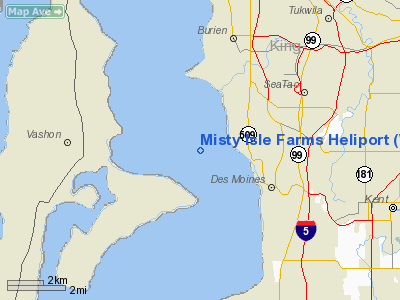
Misty Isle Farms Heliport |
Location & QuickFacts
| FAA Information Effective: | 2008-09-25 |
| Airport Identifier: | WN96 |
| Airport Status: | Operational |
| Longitude/Latitude: | 122-22-14.4490W/47-24-46.3560N
-122.370680/47.412877 (Estimated) |
| Elevation: | 351 ft / 106.98 m (Estimated) |
| Land: | 0 acres |
| From nearest city: | 3 nautical miles S of Vashon Island, WA |
| Location: | King County, WA |
| Magnetic Variation: | 20E (1990) |
Owner & Manager
| Ownership: | Privately owned |
| Owner: | Thomas J. Stewart |
| Address: | 12011 S.w. 220th
Vashon Island, WA 98070 |
| Phone number: | 206-933-5241 |
| Manager: | Lincoln Ferris, Vp |
| Address: | P.o. Box 3627
Seattle, WA 98124 |
| Phone number: | 206-933-5241 |
Airport Operations and Facilities
| Airport Use: | Private |
| Segmented Circle: | No |
| Control Tower: | No |
| Lighting Schedule: | PHONE REQ
FOR PERIMETER LGTS CALL 206-933-5241. |
| Sectional chart: | Seattle |
| Region: | ANM - Northwest Mountain |
| Boundary ARTCC: | ZSE - Seattle |
| Tie-in FSS: | SEA - Seattle |
| FSS on Airport: | No |
| FSS Toll Free: | 1-800-WX-BRIEF |
Runway Information
Helipad H1
| Dimension: | 12 x 10 ft / 3.7 x 3.0 m |
| Surface: | CONC,
LNDG PAD IS ELEVATED. |
| |
Runway H1 |
Runway |
| Traffic Pattern: | Left | Left |
|
Radio Navigation Aids
| ID |
Type |
Name |
Ch |
Freq |
Var |
Dist |
| ODD | NDB | Dondo | | 224.00 | 19E | 3.9 nm |
| RNT | NDB | Renton | | 353.00 | 20E | 8.0 nm |
| PWT | NDB | Kitsap | | 206.00 | 20E | 16.4 nm |
| GR | NDB | Graye | | 216.00 | 18E | 18.4 nm |
| CAN | NDB | Carney | | 274.00 | 20E | 19.0 nm |
| LAC | NDB | Lacomas | | 328.00 | 18E | 25.5 nm |
| MNC | NDB | Mason County | | 348.00 | 19E | 30.8 nm |
| PAE | VOR/DME | Paine | 043X | 110.60 | 20E | 30.7 nm |
| SEA | VORTAC | Seattle | 115X | 116.80 | 19E | 2.8 nm |
| TCM | VORTAC | Mcchord | 033X | 109.60 | 22E | 16.5 nm |
| OLM | VORTAC | Olympia | 081X | 113.40 | 19E | 34.3 nm |
| SEA | VOT | Seattle-tacoma | | 117.50 | | 3.3 nm |
| BFI | VOT | Boeing Field | | 108.60 | | 7.4 nm |
Images and information placed above are from
http://www.airport-data.com/airport/WN96/
We thank them for the data!
| General Info
|
| Country |
United States
|
| State |
WASHINGTON
|
| FAA ID |
WN96
|
| Latitude |
47-24-46.356N
|
| Longitude |
122-22-14.449W
|
| Elevation |
351 feet
|
| Near City |
VASHON ISLAND
|
We don't guarantee the information is fresh and accurate. The data may
be wrong or outdated.
For more up-to-date information please refer to other sources.
|
|


