 |
|
Location & QuickFacts
| FAA Information Effective: | 2008-09-25 |
| Airport Identifier: | WA71 |
| Airport Status: | Operational |
| Longitude/Latitude: | 122-03-38.2200W/47-32-14.1600N
-122.060617/47.537267 (Estimated) |
| Elevation: | 100 ft / 30.48 m (Estimated) |
| Land: | 28 acres |
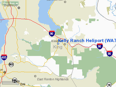
| From nearest city: | 3 nautical miles NE of Issaquah, WA |
| Location: | King County, WA |
| Magnetic Variation: | () |
Owner & Manager
| Ownership: | Privately owned |
| Owner: | David Kelly |
| Address: | 7212 Renton-iss Rd Se
Issaquah, WA 98027 |
| Phone number: | 425-392-0104 |
| Manager: | David Kelly |
| Address: | 7212 Renton-iss Rd Se
Issaquah, WA 98027 |
| Phone number: | 425-392-0104 |
Airport Operations and Facilities
| Airport Use: | Private |
| Wind indicator: | Yes |
| Segmented Circle: | No |
| Control Tower: | No |
| Sectional chart: | Seattle |
| Region: | ANM - Northwest Mountain |
| Boundary ARTCC: | ZSE - Seattle |
| Tie-in FSS: | SEA - Seattle |
| FSS Toll Free: | 1-800-WX-BRIEF |
Runway Information
Helipad H1
| Dimension: | 300 x 150 ft / 91.4 x 45.7 m |
| Surface: | ASPH, |
| |
Runway H1 |
Runway |
| Traffic Pattern: | Left | Left |
|
Radio Navigation Aids
| ID |
Type |
Name |
Ch |
Freq |
Var |
Dist |
| RNT | NDB | Renton | | 353.00 | 20E | 6.7 nm |
| ODD | NDB | Dondo | | 224.00 | 19E | 14.5 nm |
| PWT | NDB | Kitsap | | 206.00 | 20E | 28.4 nm |
| GR | NDB | Graye | | 216.00 | 18E | 32.1 nm |
| CAN | NDB | Carney | | 274.00 | 20E | 32.5 nm |
| LAC | NDB | Lacomas | | 328.00 | 18E | 37.7 nm |
| MNC | NDB | Mason County | | 348.00 | 19E | 45.2 nm |
| PAE | VOR/DME | Paine | 043X | 110.60 | 20E | 24.6 nm |
| SEA | VORTAC | Seattle | 115X | 116.80 | 19E | 11.8 nm |
| TCM | VORTAC | Mcchord | 033X | 109.60 | 22E | 28.9 nm |
| OLM | VORTAC | Olympia | 081X | 113.40 | 19E | 48.3 nm |
| BFI | VOT | Boeing Field | | 108.60 | | 9.8 nm |
| SEA | VOT | Seattle-tacoma | | 117.50 | | 11.4 nm |
Images and information placed above are from
http://www.airport-data.com/airport/WA71/
We thank them for the data!
|
|


