 |
|
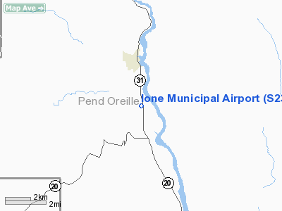
Location & QuickFacts
| FAA Information Effective: | 2008-09-25 |
| Airport Identifier: | S23 |
| Airport Status: | Operational |
| Longitude/Latitude: | 117-24-46.8440W/48-42-28.9950N
-117.413012/48.708054 (Estimated) |
| Elevation: | 2108 ft / 642.52 m (Estimated) |
| Land: | 68 acres |
| From nearest city: | 2 nautical miles S of Ione, WA |
| Location: | Pend Oreille County, WA |
| Magnetic Variation: | 20E (1985) |
Owner & Manager
| Ownership: | Publicly owned |
| Owner: | City Of Ione |
| Address: | Po Box 498
Ione, WA 99139 |
| Phone number: | 509-442-3611 |
| Manager: | Ken Timmreck |
| Address: | Po Box 498
Ione, WA 99139 |
| Phone number: | 509-442-3948 |
Airport Operations and Facilities
| Airport Use: | Open to public |
| Wind indicator: | Yes |
| Segmented Circle: | No |
| Control Tower: | No |
| Lighting Schedule: | DUSK-DAWN
ACTVT MIRL RY 15/33 - CTAF. MIRL RY 15/33 PCL MED & HIGH INTST OTS INDEFLY. |
| Beacon Color: | Clear-Green (lighted land airport) |
| Landing fee charge: | No |
| Sectional chart: | Seattle |
| Region: | ANM - Northwest Mountain |
| Boundary ARTCC: | ZSE - Seattle |
| Tie-in FSS: | SEA - Seattle |
| FSS on Airport: | No |
| FSS Toll Free: | 1-800-WX-BRIEF |
| NOTAMs Facility: | SEA (NOTAM-d service avaliable) |
| Federal Agreements: | N1 |
Airport Communications
Airport Services
| Airframe Repair: | NONE |
| Power Plant Repair: | NONE |
| Bottled Oxygen: | NONE |
| Bulk Oxygen: | NONE |
Runway Information
Runway 15/33
| Dimension: | 4059 x 45 ft / 1237.2 x 13.7 m |
| Surface: | ASPH, Good Condition |
| Edge Lights: | Medium |
| |
Runway 15 |
Runway 33 |
| Longitude: | 117-24-53.5070W | 117-24-40.1830W |
| Latitude: | 48-42-48.5280N | 48-42-09.4620N |
| Elevation: | 2108.00 ft | 2104.00 ft |
| Traffic Pattern: | Left | Left |
| Markings: | Nonstandard, Good Condition
RY 15 NUMBERS SMALLER THAN STD. | Nonstandard, Good Condition
RY 33 NUMBERS SMALLER THAN STD. |
| Crossing Height: | 0.00 ft | 35.00 ft |
| VASI: | | 2-light PAPI on left side |
| Visual Glide Angle: | 0.00° | 3.00° |
| Obstruction: | 3 ft fence, 208.0 ft from runway, 2:1 slope to clear
6' SIGN 40', 50' R; 6' SIGN AT 164', 22' R; CONC POST AT 164', 115' L; BLDG AT 180', 125' L. | 5 ft road, 200.0 ft from runway, 40 ft right of centerline
RWY 33 RD 0'-30' R FM 200' TO THR |
|
Helipad H1
| Dimension: | 60 x 60 ft / 18.3 x 18.3 m |
| Surface: | CONC, Good Condition |
| Edge Lights: | Medium |
| |
Runway H1 |
Runway |
| Traffic Pattern: | Left | Left |
| Markings: | Basic, Good Condition | ,
RY 15 NUMBERS SMALLER THAN STD.
RY 33 NUMBERS SMALLER THAN STD. |
|
Radio Navigation Aids
| ID |
Type |
Name |
Ch |
Freq |
Var |
Dist |
| ION | NDB | Ione | | 379.00 | 21E | 0.1 nm |
| EF | NDB | Champion | | 206.00 | 20E | 34.1 nm |
| YK | NDB | Brilliant | | 269.00 | 20E | 38.1 nm |
| SZT | NDB | Sandpoe | | 264.00 | 20E | 42.1 nm |
| DPY | NDB | Deer Park | | 216.00 | 19E | 44.5 nm |
| CG | NDB | Castlegar | | 227.00 | 20E | 44.9 nm |
Remarks
- SMALL TREES IN PRIM SFC.
- WILDLIFE INVOF RY.
- ESTABD PRIOR TO 15 MAY 1959.
Images and information placed above are from
http://www.airport-data.com/airport/S23/
We thank them for the data!
| General Info
|
| Country |
United States
|
| State |
WASHINGTON
|
| FAA ID |
S23
|
| Latitude |
48-42-26.191N
|
| Longitude |
117-24-45.373W
|
| Elevation |
2107 feet
|
| Near City |
IONE
|
We don't guarantee the information is fresh and accurate. The data may
be wrong or outdated.
For more up-to-date information please refer to other sources.
|
|


