 |
|
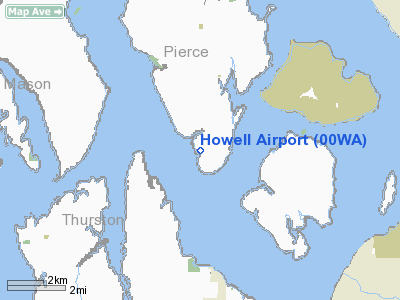
Location & QuickFacts
| FAA Information Effective: | 2008-09-25 |
| Airport Identifier: | 00WA |
| Airport Status: | Operational |
| Longitude/Latitude: | 122-46-18.4800W/47-10-42.3500N
-122.771800/47.178431 (Estimated) |
| Elevation: | 150 ft / 45.72 m (Estimated) |
| Land: | 23 acres |
| From nearest city: | 2 nautical miles SW of Longbranch, WA |
| Location: | Pierce County, WA |
| Magnetic Variation: | 19E (1995) |
Owner & Manager
| Ownership: | Privately owned |
| Owner: | Clifford & Yukiko Howell |
| Address: | Po Box 27
Lakebay, WA 98349 |
| Phone number: | 253-884-2978 |
| Manager: | Clifford Howell |
| Address: | Po Box 27
Lakebay, WA 98349 |
| Phone number: | 253-884-2978 |
Airport Operations and Facilities
| Airport Use: | Private |
| Wind indicator: | Yes |
| Segmented Circle: | No |
| Control Tower: | No |
| Sectional chart: | Seattle |
| Region: | ANM - Northwest Mountain |
| Boundary ARTCC: | ZSE - Seattle |
| Tie-in FSS: | SEA - Seattle |
| FSS Toll Free: | 1-800-WX-BRIEF |
Runway Information
Runway 08/26
| Dimension: | 1105 x 70 ft / 336.8 x 21.3 m |
| Surface: | TURF, Good Condition |
| |
Runway 08 |
Runway 26 |
| Traffic Pattern: | Right | Left |
|
Radio Navigation Aids
| ID |
Type |
Name |
Ch |
Freq |
Var |
Dist |
| GR | NDB | Graye | | 216.00 | 18E | 7.0 nm |
| MNC | NDB | Mason County | | 348.00 | 19E | 13.5 nm |
| LAC | NDB | Lacomas | | 328.00 | 18E | 13.5 nm |
| CAN | NDB | Carney | | 274.00 | 20E | 14.2 nm |
| PWT | NDB | Kitsap | | 206.00 | 20E | 18.9 nm |
| ODD | NDB | Dondo | | 224.00 | 19E | 21.9 nm |
| RNT | NDB | Renton | | 353.00 | 20E | 29.6 nm |
| TDO | NDB | Toledo | | 219.00 | 20E | 42.3 nm |
| PAE | VOR/DME | Paine | 043X | 110.60 | 20E | 48.9 nm |
| TCM | VORTAC | Mcchord | 033X | 109.60 | 22E | 12.3 nm |
| OLM | VORTAC | Olympia | 081X | 113.40 | 19E | 13.5 nm |
| SEA | VORTAC | Seattle | 115X | 116.80 | 19E | 24.4 nm |
| SEA | VOT | Seattle-tacoma | | 117.50 | | 24.9 nm |
| BFI | VOT | Boeing Field | | 108.60 | | 28.4 nm |
Remarks
- RY 26 UNUSABLE FOR LNDG AND RY 08 UNUSABLE FOR TKOF DUE TO 50 FT DOWNSLOPE TO THE WEST.
Images and information placed above are from
http://www.airport-data.com/airport/00WA/
We thank them for the data!
| General Info
|
| Country |
United States
|
| State |
WASHINGTON
|
| FAA ID |
00WA
|
| Latitude |
47-10-42.350N
|
| Longitude |
122-46-18.480W
|
| Elevation |
150 feet
|
| Near City |
LONGBRANCH
|
We don't guarantee the information is fresh and accurate. The data may
be wrong or outdated.
For more up-to-date information please refer to other sources.
|
|


