 |
|
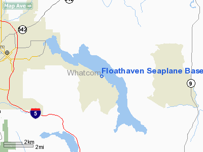
Floathaven Seaplane Base Airport |
Location & QuickFacts
| FAA Information Effective: | 2008-09-25 |
| Airport Identifier: | 0W7 |
| Airport Status: | Operational |
| Longitude/Latitude: | 122-20-09.5870W/48-43-41.3990N
-122.335996/48.728166 (Estimated) |
| Elevation: | 307 ft / 93.57 m (Estimated) |
| Land: | 0 acres |
| From nearest city: | 6 nautical miles SE of Bellingham, WA |
| Location: | Whatcom County, WA |
| Magnetic Variation: | 21E (1985) |
Owner & Manager
| Ownership: | Privately owned |
| Owner: | Mellemark Inc. |
| Address: | 14915 58th Lane Ne
Kennmore, WA 98028 |
| Phone number: | 425-814-2290 |
| Manager: | Mark Schoening |
| Address: | 14915 58th Lane Ne
Kennmore, WA 98028 |
| Phone number: | 425-814-2290 |
Airport Operations and Facilities
| Airport Use: | Open to public |
| Segmented Circle: | No |
| Control Tower: | No |
| Landing fee charge: | No |
| Sectional chart: | Seattle |
| Region: | ANM - Northwest Mountain |
| Boundary ARTCC: | ZSE - Seattle |
| Tie-in FSS: | SEA - Seattle |
| FSS on Airport: | No |
| FSS Toll Free: | 1-800-WX-BRIEF |
| NOTAMs Facility: | SEA (NOTAM-d service avaliable) |
Airport Communications
Airport Services
| Airframe Repair: | MINOR
CALL 425-814-2290 PRIOR TO ARRIVAL TO ARRANGE SVCS. |
| Power Plant Repair: | MINOR |
| Bottled Oxygen: | NONE |
| Bulk Oxygen: | NONE |
Runway Information
Runway 12/30
| Dimension: | 10000 x 4000 ft / 3048.0 x 1219.2 m |
| Surface: | WATER, |
| |
Runway 12 |
Runway 30 |
| Elevation: | 307.00 ft | 307.00 ft |
| Traffic Pattern: | Left | Left |
|
Radio Navigation Aids
| ID |
Type |
Name |
Ch |
Freq |
Var |
Dist |
| BVS | NDB | Skagit/bay View | | 240.00 | 21E | 15.9 nm |
| XX | NDB | Abbotsford | | 344.00 | 21E | 18.3 nm |
| LU | NDB | Cultus | | 214.00 | 22E | 20.9 nm |
| WC | NDB | White Rock | | 332.00 | 21E | 22.8 nm |
| OPZ | NDB | Lopez Island | | 356.00 | 21E | 27.6 nm |
| FHR | NDB | Friday Harbor | | 284.00 | 20E | 30.0 nm |
| AP | NDB | Active Pass | | 378.00 | 21E | 38.8 nm |
| VR | NDB | Vancouver | | 266.00 | 21E | 39.0 nm |
| YJ | NDB | Victoria | | 200.00 | 21E | 42.5 nm |
| V | NDB | Victor | | 368.00 | 22E | 44.6 nm |
| MB | NDB | Mill Bay | | 293.00 | 21E | 47.8 nm |
| NUW | TACAN | Whidbey Island | 085X | | 21E | 25.9 nm |
| CVV | VOR/DME | Penn Cove | 119X | 117.20 | 19E | 32.9 nm |
| YYJ | VOR/DME | Victoria | 084X | 113.70 | 21E | 45.5 nm |
| PAE | VOR/DME | Paine | 043X | 110.60 | 20E | 48.6 nm |
| HUH | VORTAC | Whatcom | 077X | 113.00 | 20E | 16.2 nm |
| YVR | VORTAC | Vancouver | 44 | 115.90 | 21E | 38.4 nm |
Remarks
- CANOE, SAILBOAT, & HANG GLIDER ACTIVITY INV OF ARPT.
- LAND AND TAKE OFF IN THE CENTER OF THE LAKE.
- AVOID FLYING OVER NOISE SENSITIVE AREAS DURING TO/LDG
- ESTABD PRIOR TO 5/15/59.
Images and information placed above are from
http://www.airport-data.com/airport/0W7/
We thank them for the data!
| General Info
|
| Country |
United States
|
| State |
WASHINGTON
|
| FAA ID |
0W7
|
| Latitude |
48-43-41.399N
|
| Longitude |
122-20-09.587W
|
| Elevation |
307 feet
|
| Near City |
BELLINGHAM
|
We don't guarantee the information is fresh and accurate. The data may
be wrong or outdated.
For more up-to-date information please refer to other sources.
|
|


