 |
|
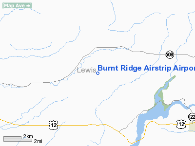
Burnt Ridge Airstrip Airport |
Location & QuickFacts
| FAA Information Effective: | 2008-09-25 |
| Airport Identifier: | WN74 |
| Airport Status: | Operational |
| Longitude/Latitude: | 122-37-34.4140W/46-35-07.3820N
-122.626226/46.585384 (Estimated) |
| Elevation: | 1070 ft / 326.14 m (Estimated) |
| Land: | 30 acres |
| From nearest city: | 4 nautical miles E of Onalaska, WA |
| Location: | Lewis County, WA |
| Magnetic Variation: | 20E (1985) |
Owner & Manager
| Ownership: | Privately owned |
| Owner: | Chuck Milton & Patrick Clary |
| Address: | 429 Burnt Ridge Road
Onalaska, WA 98570 |
| Phone number: | 360-985-0022
OR 360-880-6180. |
| Manager: | Chuck Milton & Patrick Clary
CO-OWNER |
| Address: | 431 Burnt Ridge Road
Onalaska, WA 98570 |
| Phone number: | 360-985-0775 |
Airport Operations and Facilities
| Airport Use: | Private |
| Wind indicator: | Yes |
| Segmented Circle: | No |
| Control Tower: | No |
| Sectional chart: | Seattle |
| Region: | ANM - Northwest Mountain |
| Boundary ARTCC: | ZSE - Seattle |
| Tie-in FSS: | SEA - Seattle |
| FSS Toll Free: | 1-800-WX-BRIEF |
Runway Information
Runway 16/34
| Dimension: | 2000 x 30 ft / 609.6 x 9.1 m |
| Surface: | TURF, |
| |
Runway 16 |
Runway 34 |
| Traffic Pattern: | Left | Left |
|
Radio Navigation Aids
| ID |
Type |
Name |
Ch |
Freq |
Var |
Dist |
| TDO | NDB | Toledo | | 219.00 | 20E | 10.3 nm |
| LAC | NDB | Lacomas | | 328.00 | 18E | 25.6 nm |
| LSO | NDB | Kelso | | 256.00 | 21E | 28.4 nm |
| GR | NDB | Graye | | 216.00 | 18E | 34.0 nm |
| MNC | NDB | Mason County | | 348.00 | 19E | 44.1 nm |
| PEN | NDB | Karpen | | 201.00 | 20E | 48.0 nm |
| ODD | NDB | Dondo | | 224.00 | 19E | 48.6 nm |
| OLM | VORTAC | Olympia | 081X | 113.40 | 19E | 25.8 nm |
| TCM | VORTAC | Mcchord | 033X | 109.60 | 22E | 34.4 nm |
Remarks
- FILED FOR RECORD PURPOSES ONLY.
Images and information placed above are from
http://www.airport-data.com/airport/WN74/
We thank them for the data!
| General Info
|
| Country |
United States
|
| State |
WASHINGTON
|
| FAA ID |
WN74
|
| Latitude |
46-35-07.382N
|
| Longitude |
122-37-34.414W
|
| Elevation |
1070 feet
|
| Near City |
ONALASKA
|
We don't guarantee the information is fresh and accurate. The data may
be wrong or outdated.
For more up-to-date information please refer to other sources.
|
|


