 |
|
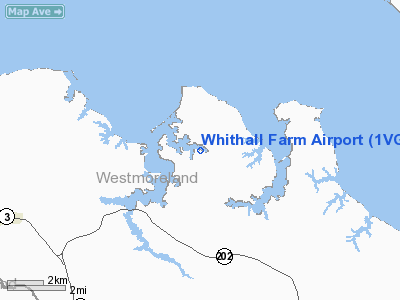
Location & QuickFacts
| FAA Information Effective: | 2008-09-25 |
| Airport Identifier: | 1VG2 |
| Airport Status: | Operational |
| Longitude/Latitude: | 076-41-21.0000W/38-07-39.6000N
-76.689167/38.127667 (Estimated) |
| Elevation: | 23 ft / 7.01 m () |
| Land: | 0 acres |
| From nearest city: | 8 nautical miles NE of Montross, VA |
| Location: | Westmoreland County, VA |
| Magnetic Variation: | 11W (2000) |
Owner & Manager
| Ownership: | Privately owned |
| Address: |
|
| Address: |
|
Airport Operations and Facilities
| Airport Use: | Private |
| Wind indicator: | Yes |
| Segmented Circle: | No |
| Control Tower: | No |
| Sectional chart: | Washington |
| Region: | AEA - Eastern |
| Boundary ARTCC: | ZDC - Washington |
| Tie-in FSS: | DCA - Leesburg |
| FSS Toll Free: | 1-800-WX-BRIEF |
Runway Information
Runway 01/19
| Dimension: | 2800 x 50 ft / 853.4 x 15.2 m |
| Surface: | TURF-GRVL, |
| |
Runway 01 |
Runway 19 |
| Traffic Pattern: | Left | Left |
| Obstruction: | 35 ft pline, 800.0 ft from runway | 15 ft road, 600.0 ft from runway |
|
Radio Navigation Aids
| ID |
Type |
Name |
Ch |
Freq |
Var |
Dist |
| NHK | NDB | Patuxent | | 400.00 | 10W | 16.5 nm |
| APH | NDB | A P Hill | | 396.00 | 10W | 30.2 nm |
| EZF | NDB | Shannon | | 237.00 | 10W | 36.9 nm |
| VKX | NDB | Potomac | | 241.00 | 10W | 39.4 nm |
| CGE | NDB | Cambridge | | 355.00 | 10W | 39.6 nm |
| DC | NDB | Oxonn | | 332.00 | 11W | 41.5 nm |
| LJK | NDB | Ashey | | 280.00 | 09W | 43.1 nm |
| DCA | VOR/DME | Washington | 047X | 111.00 | 09W | 46.9 nm |
| PXT | VORTAC | Patuxent | 123X | 117.60 | 10W | 16.7 nm |
| BRV | VORTAC | Brooke | 092X | 114.50 | 09W | 33.8 nm |
| OTT | VORTAC | Nottingham | 084X | 113.70 | 10W | 34.9 nm |
| HCM | VORTAC | Harcum | 025X | 108.80 | 07W | 40.8 nm |
| ADW | VORTAC | Andrews | 078X | 113.10 | 10W | 41.7 nm |
| RIC | VORTAC | Richmond | 088X | 114.10 | 09W | 48.1 nm |
| ADW | VOT | Andrews Afb | | 109.60 | | 40.7 nm |
| DCA | VOT | Washington National | | 109.40 | | 46.1 nm |
Remarks
- PRVDD DALGT VFR ONLY, CLEAR 20:1 APCH/DEP PATH, TREES EACH SIDE OF RY KEPT OUT OF PRIMARY SFC, ASSURE CO-ORDINATION WITH SANFORD ARPT FOR TFC PATTERN FAMILIARITY.
Images and information placed above are from
http://www.airport-data.com/airport/1VG2/
We thank them for the data!
| General Info
|
| Country |
United States
|
| State |
VIRGINIA
|
| FAA ID |
1VG2
|
| Latitude |
38-07-39.600N
|
| Longitude |
076-41-21.000W
|
| Elevation |
23 feet
|
| Near City |
MONTROSS
|
We don't guarantee the information is fresh and accurate. The data may
be wrong or outdated.
For more up-to-date information please refer to other sources.
|
|


