 |
|
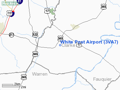
Location & QuickFacts
| FAA Information Effective: | 2008-09-25 |
| Airport Identifier: | 3VA7 |
| Airport Status: | Operational |
| Longitude/Latitude: | 078-05-28.9950W/39-03-45.3840N
-78.091387/39.062607 (Estimated) |
| Elevation: | 610 ft / 185.93 m (Estimated) |
| Land: | 0 acres |
| From nearest city: | 1 nautical miles NE of White Post, VA |
| Location: | Clarke County, VA |
| Magnetic Variation: | 09W (1985) |
Owner & Manager
| Ownership: | Privately owned |
| Owner: | Kenneth Conn |
| Address: | 16054 Windsock Way
Culpeper, VA 22701 |
| Phone number: | 703-825-4206 |
| Manager: | Martha Conn |
| Address: | 16054 Windsock Way
Culpeper, VA 22701 |
| Phone number: | 703-825-4206 |
Airport Operations and Facilities
| Airport Use: | Private |
| Wind indicator: | Yes |
| Segmented Circle: | No |
| Control Tower: | No |
| Landing fee charge: | No |
| Sectional chart: | Washington |
| Region: | AEA - Eastern |
| Boundary ARTCC: | ZDC - Washington |
| Tie-in FSS: | DCA - Leesburg |
| FSS on Airport: | No |
| FSS Toll Free: | 1-800-WX-BRIEF |
Airport Services
| Airframe Repair: | NONE |
| Power Plant Repair: | NONE |
Runway Information
Runway 04/22
| Dimension: | 2000 x 75 ft / 609.6 x 22.9 m |
| Surface: | TURF, |
| |
Runway 04 |
Runway 22 |
| Traffic Pattern: | Left | Left |
|
Radio Navigation Aids
| ID |
Type |
Name |
Ch |
Freq |
Var |
Dist |
| TZ | NDB | Cogan | | 364.00 | 10W | 1.8 nm |
| GDX | NDB | Goodwin Lake | | 227.00 | 08W | 13.8 nm |
| LUA | NDB | Caverns | | 245.00 | 09W | 28.2 nm |
| CJR | NDB | Culpeper | | 252.00 | 09W | 33.8 nm |
| MSQ | NDB | Nailr | | 351.00 | 10W | 37.6 nm |
| GAI | NDB | Gaithersburg | | 385.00 | 09W | 43.6 nm |
| GTN | NDB | Georgetown | | 323.00 | 09W | 45.9 nm |
| CBE | NDB | Cumberland | | 317.00 | 07W | 46.6 nm |
| FDK | VOR | Frederick | | 109.00 | 08W | 39.4 nm |
| HGR | VOR | Hagerstown | | 109.80 | 07W | 39.7 nm |
| ESL | VOR/DME | Kessel | 045X | 110.80 | 06W | 43.0 nm |
| LDN | VORTAC | Linden | 090X | 114.30 | 06W | 13.6 nm |
| MRB | VORTAC | Martinsburg | 058X | 112.10 | 07W | 22.5 nm |
| CSN | VORTAC | Casanova | 110X | 116.30 | 06W | 27.4 nm |
| AML | VORTAC | Armel | 082X | 113.50 | 08W | 30.2 nm |
Remarks
- PERSONAL OR PVT USE ONLY.
Images and information placed above are from
http://www.airport-data.com/airport/3VA7/
We thank them for the data!
| General Info
|
| Country |
United States
|
| State |
VIRGINIA
|
| FAA ID |
3VA7
|
| Latitude |
39-03-45.384N
|
| Longitude |
078-05-28.995W
|
| Elevation |
610 feet
|
| Near City |
WHITE POST
|
We don't guarantee the information is fresh and accurate. The data may
be wrong or outdated.
For more up-to-date information please refer to other sources.
|
|


