 |
|
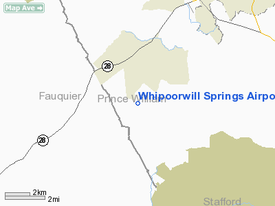
Whipoorwill Springs Airport |
Location & QuickFacts
| FAA Information Effective: | 2008-09-25 |
| Airport Identifier: | 03VA |
| Airport Status: | Operational |
| Longitude/Latitude: | 077-34-46.9600W/38-39-52.4280N
-77.579711/38.664563 (Estimated) |
| Elevation: | 250 ft / 76.20 m (Surveyed) |
| Land: | 47 acres |
| From nearest city: | 2 nautical miles S of Nokesville, VA |
| Location: | Prince William County, VA |
| Magnetic Variation: | 09W (1985) |
Owner & Manager
| Ownership: | Privately owned |
| Owner: | William F. Elliott |
| Address: | 2540 Cross Country Drive
Daytona Beach, FL 32124 |
| Phone number: | 904-756-8509 |
| Manager: | Bill Elliott |
| Address: | 11605 Choir Lane
Fairfax Station, VA 22039 |
| Phone number: | 703-978-4249
OR 703-594-3477 |
Airport Operations and Facilities
| Airport Use: | Private |
| Wind indicator: | Yes |
| Segmented Circle: | No |
| Control Tower: | No |
| Lighting Schedule: | NONE |
| Landing fee charge: | No |
| Sectional chart: | Washington |
| Region: | AEA - Eastern |
| Boundary ARTCC: | ZDC - Washington |
| Tie-in FSS: | DCA - Leesburg |
| FSS on Airport: | No |
| FSS Toll Free: | 1-800-WX-BRIEF |
Runway Information
Runway 14/32
| Dimension: | 2250 x 100 ft / 685.8 x 30.5 m |
| Surface: | TURF, Good Condition |
| |
Runway 14 |
Runway 32 |
| Traffic Pattern: | Right | Left |
| Displaced threshold: | 450.00 ft | 0.00 ft |
| Obstruction: | 40 ft pline, 450.0 ft from runway | |
|
Radio Navigation Aids
| ID |
Type |
Name |
Ch |
Freq |
Var |
Dist |
| CJR | NDB | Culpeper | | 252.00 | 09W | 15.3 nm |
| MSQ | NDB | Nailr | | 351.00 | 10W | 19.8 nm |
| GDX | NDB | Goodwin Lake | | 227.00 | 08W | 21.0 nm |
| EZF | NDB | Shannon | | 237.00 | 10W | 24.7 nm |
| GTN | NDB | Georgetown | | 323.00 | 09W | 26.6 nm |
| DC | NDB | Oxonn | | 332.00 | 11W | 26.6 nm |
| VKX | NDB | Potomac | | 241.00 | 10W | 29.7 nm |
| TZ | NDB | Cogan | | 364.00 | 10W | 34.2 nm |
| GAI | NDB | Gaithersburg | | 385.00 | 09W | 36.0 nm |
| APH | NDB | A P Hill | | 396.00 | 10W | 36.7 nm |
| IQK | NDB | Louisa | | 382.00 | 09W | 40.9 nm |
| LUA | NDB | Caverns | | 245.00 | 09W | 41.9 nm |
| BUH | NDB | Anne Arundel | | 260.00 | 10W | 45.9 nm |
| FDK | VOR | Frederick | | 109.00 | 08W | 45.9 nm |
| DCA | VOR/DME | Washington | 047X | 111.00 | 09W | 28.0 nm |
| CSN | VORTAC | Casanova | 110X | 116.30 | 06W | 13.5 nm |
| AML | VORTAC | Armel | 082X | 113.50 | 08W | 17.1 nm |
| BRV | VORTAC | Brooke | 092X | 114.50 | 09W | 22.4 nm |
| LDN | VORTAC | Linden | 090X | 114.30 | 06W | 31.5 nm |
| ADW | VORTAC | Andrews | 078X | 113.10 | 10W | 34.5 nm |
| OTT | VORTAC | Nottingham | 084X | 113.70 | 10W | 39.3 nm |
| MRB | VORTAC | Martinsburg | 058X | 112.10 | 07W | 45.1 nm |
| GVE | VORTAC | Gordonsville | 103X | 115.60 | 06W | 47.6 nm |
| DCA | VOT | Washington National | | 109.40 | | 27.8 nm |
| ADW | VOT | Andrews Afb | | 109.60 | | 33.6 nm |
Remarks
- RUNWAY CLOSED UNTIL FURTHER NOTICE--CONSTRUCTION TAKING PLACE.
Images and information placed above are from
http://www.airport-data.com/airport/03VA/
We thank them for the data!
| General Info
|
| Country |
United States
|
| State |
VIRGINIA
|
| FAA ID |
03VA
|
| Latitude |
38-39-52.428N
|
| Longitude |
077-34-46.960W
|
| Elevation |
250 feet
|
| Near City |
NOKESVILLE
|
We don't guarantee the information is fresh and accurate. The data may
be wrong or outdated.
For more up-to-date information please refer to other sources.
|
|


