 |
|
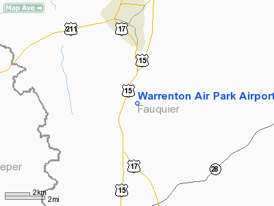
Warrenton Air Park Airport |
Location & QuickFacts
| FAA Information Effective: | 2008-09-25 |
| Airport Identifier: | 7VG0 |
| Airport Status: | Operational |
| Longitude/Latitude: | 077-47-13.9750W/38-39-20.4330N
-77.787215/38.655676 (Estimated) |
| Elevation: | 442 ft / 134.72 m (Surveyed) |
| Land: | 60 acres |
| From nearest city: | 4 nautical miles S of Warrenton, VA |
| Location: | Fauquier County, VA |
| Magnetic Variation: | 09W (1985) |
Owner & Manager
| Ownership: | Privately owned |
| Owner: | C.e. Beatley, Jr. |
| Address: | 4875 Maury Lane
Alexandria, VA 22304 |
| Phone number: | 703-347-2747 |
| Manager: | C.e. Beatley, Jr. |
| Address: | 4875 Maury Lane
Alexandria, VA 22304 |
| Phone number: | 703-347-2747 |
Airport Operations and Facilities
| Airport Use: | Private |
| Wind indicator: | Yes |
| Segmented Circle: | Yes |
| Control Tower: | No |
| Landing fee charge: | No |
| Sectional chart: | Washington |
| Region: | AEA - Eastern |
| Boundary ARTCC: | ZDC - Washington |
| Tie-in FSS: | DCA - Leesburg |
| FSS on Airport: | No |
| FSS Toll Free: | 1-800-WX-BRIEF |
Airport Services
| Airframe Repair: | NONE |
| Power Plant Repair: | NONE |
| Bottled Oxygen: | NONE |
| Bulk Oxygen: | NONE |
Runway Information
Runway 04/22
| Dimension: | 2215 x 70 ft / 675.1 x 21.3 m
UPSLOPE LAST 800 FT OF RY 33.
NARROWS TO 70 FT USBL AT BRIDGE OVER STREAM MOWED TO 240 FT WIDE.
WIDTH MOWED & MKD BY ORANGE CONES; TURF AREA APRXLY 250 FT WIDE. |
| Surface: | TURF, Good Condition |
| |
Runway 04 |
Runway 22 |
| Traffic Pattern: | Left | Left |
| Displaced threshold: | 0.00 ft | 1000.00 ft |
| Obstruction: | 4 ft fence, 6.0 ft from runway, 1:1 slope to clear | 10 ft trees, 100.0 ft from runway |
|
Runway 15/33
| Dimension: | 2000 x 70 ft / 609.6 x 21.3 m
UPSLOPE LAST 800 FT OF RY 33.
NARROWS TO 70 FT USBL AT BRIDGE OVER STREAM MOWED TO 240 FT WIDE.
WIDTH MOWED & MKD BY ORANGE CONES; TURF AREA APRXLY 250 FT WIDE. |
| Surface: | TURF, Good Condition |
| |
Runway 15 |
Runway 33 |
| Traffic Pattern: | Left | Left |
| Obstruction: | 40 ft trees, 25.0 ft from runway, 80 ft right of centerline | 40 ft trees, 40.0 ft from runway, 95 ft right of centerline, 1:1 slope to clear |
|
Radio Navigation Aids
| ID |
Type |
Name |
Ch |
Freq |
Var |
Dist |
| CJR | NDB | Culpeper | | 252.00 | 09W | 8.2 nm |
| MSQ | NDB | Nailr | | 351.00 | 10W | 13.3 nm |
| GDX | NDB | Goodwin Lake | | 227.00 | 08W | 18.0 nm |
| EZF | NDB | Shannon | | 237.00 | 10W | 28.3 nm |
| TZ | NDB | Cogan | | 364.00 | 10W | 29.1 nm |
| LUA | NDB | Caverns | | 245.00 | 09W | 32.2 nm |
| GTN | NDB | Georgetown | | 323.00 | 09W | 35.2 nm |
| DC | NDB | Oxonn | | 332.00 | 11W | 36.3 nm |
| IQK | NDB | Louisa | | 382.00 | 09W | 38.3 nm |
| VKX | NDB | Potomac | | 241.00 | 10W | 39.4 nm |
| APH | NDB | A P Hill | | 396.00 | 10W | 40.5 nm |
| GAI | NDB | Gaithersburg | | 385.00 | 09W | 42.4 nm |
| FDK | VOR | Frederick | | 109.00 | 08W | 49.4 nm |
| DCA | VOR/DME | Washington | 047X | 111.00 | 09W | 37.3 nm |
| CSN | VORTAC | Casanova | 110X | 116.30 | 06W | 3.8 nm |
| AML | VORTAC | Armel | 082X | 113.50 | 08W | 22.5 nm |
| LDN | VORTAC | Linden | 090X | 114.30 | 06W | 23.0 nm |
| BRV | VORTAC | Brooke | 092X | 114.50 | 09W | 28.0 nm |
| GVE | VORTAC | Gordonsville | 103X | 115.60 | 06W | 42.3 nm |
| MRB | VORTAC | Martinsburg | 058X | 112.10 | 07W | 44.0 nm |
| ADW | VORTAC | Andrews | 078X | 113.10 | 10W | 44.1 nm |
| OTT | VORTAC | Nottingham | 084X | 113.70 | 10W | 49.0 nm |
| DCA | VOT | Washington National | | 109.40 | | 37.1 nm |
| ADW | VOT | Andrews Afb | | 109.60 | | 43.3 nm |
Remarks
- 745' X 20' PAVED TAKEOFF PATCH RY 04/22.
- PRVDD ARPT OPERATED DURG DALGT HRS AND NO IFR OPNS CONDUCTED; PVT USE; CONSIDERATION GIVEN TO TRIMMING OR REMOVING TREES NEAR ENDS OF YOUR RY.
Images and information placed above are from
http://www.airport-data.com/airport/7VG0/
We thank them for the data!
| General Info
|
| Country |
United States
|
| State |
VIRGINIA
|
| FAA ID |
7VG0
|
| Latitude |
38-39-20.433N
|
| Longitude |
077-47-13.975W
|
| Elevation |
442 feet
|
| Near City |
WARRENTON
|
We don't guarantee the information is fresh and accurate. The data may
be wrong or outdated.
For more up-to-date information please refer to other sources.
|
|


