|
 |
|
||||
|
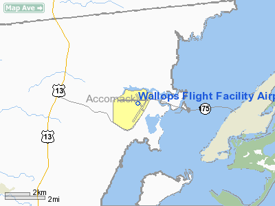
Wallops Flight Facility (WFF) (IATA: WAL, ICAO: KWAL), located on the Eastern Shore of Virginia, is operated by NASA’s Goddard Space Flight Center, primarily as a rocket launch site to support science and exploration missions for NASA and other U.S. government agencies. WFF includes an extensively instrumented range to support launches of more than a dozen types of sounding rockets, small expendable suborbital and orbital rockets, high altitude balloon flights carrying scientific instruments for atmospheric and astronomical research and—using its Research Airport—flight tests of aeronautical research aircraft including unmanned aerial vehicles. The WFF range supports science missions for the National Oceanic and Atmospheric Administration (NOAA), and occasionally for foreign governments and commercial organizations. It also supports development tests and exercises involving United States Navy aircraft and ship-based electronics and weapon systems in the Virginia Capes operating area, near the entrance to the Chesapeake Bay. In addition to its fixed-location instrumentation assets, the WFF range includes mobile radars, telemetry receivers, and command transmitters that can be deployed by aircraft to locations around the world, in order to establish a temporary range where no other instrumentation exists, to ensure safety, and to collect data in order to enable and support suborbital rocket launches from remote sites. The WFF mobile range assets have been used to support rocket launches from locations in the Arctic and Antarctic regions, South America, Africa, Europe, Australia and at sea. Workers at Wallops include approximately 1,000 full-time NASA civil service employees and contractors, 30 U.S. Navy personnel, and 100 NOAA employees. HistoryIn 1945, NASA's predecessor agency, the National Advisory Committee for Aeronautics (NACA), established a rocket launch site on Wallops Island under the direction of the Langley Research Center. This site was designated the Pilotless Aircraft Research Station and conducted high-speed aerodynamic research to supplement wind tunnel and laboratory investigations into the problems of flight. In 1958, Congress established NASA, which absorbed Langley Research Center and other NACA field centers and research facilities. At that time, the Pilotless Aircraft Research Station became a separate facility - Wallops Station - operating directly under NASA Headquarters in Washington, D.C. In 1959, NASA acquired the former Naval Air Station Chincoteague, and engineering and administrative activities were moved to this location. In 1974, the Wallops Station was named Wallops Flight Center. The name was changed to Wallops Flight Facility in 1981, when it became part of Goddard Space Flight Center in Greenbelt, Maryland. In the early years, research at Wallops concentrated on obtaining aerodynamic data at transonic and low supersonic speeds. Between 1959 and 1961, Project Mercury capsules were tested at Wallops in support of NASA's manned space flight program before astronauts were launched from Cape Canaveral Air Force Station in Florida. Some of these tests using the Little Joe booster rocket were designed to flight-qualify components of the Mercury spacecraft, including the escape and recovery systems and some of the life support systems. Two rhesus monkeys, Sam and Miss Sam, were sent aloft as pioneers for astronauts; both were recovered safely. Since 1945, the Wallops Test Range has launched more than 14,000 research vehicles in the quest for information on the flight characteristics of airplanes, launch vehicles, and spacecraft; and to increase the knowledge of the Earth's upper atmosphere and the near-space environment. The launch vehicles vary in size and power from the small Super Loki meteorological rockets to orbital-class vehicles. FacilitiesThe WFF Main Base is located on the Eastern Shore of Virginia on the Delmarva Peninsula 5 miles (8.0 km) west of Chincoteague, Virginia; approximately 90 miles (140 km) north of Norfolk, Virginia, and 40 miles (64 km) southeast of Salisbury, Maryland. WFF consists of three separate parcels of real property totaling 6,200 acres (25 km²): the Main Base, the Mainland, and the Wallops Island Launch Site. The Mainland and the Wallops Island Launch Site are approximately 7 miles (11 km) southeast of the Main Base. AirspaceWallops operates controlled airspace with Federal Aviation Administration (FAA) qualified Air Traffic Controllers including:
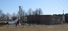
Fixed facilitiesMajor Wallops facilities include FAA-certified runways; an experimental UAV runway; and crash, fire and rescue services. WFF has facilities for the receipt, inspection, assembly, checkout and storage of rocket motors and other hazardous pyrotechnic devices. The Wallops Island Launch Site includes six launch pads, three blockhouses for launch control, and assembly buildings to support the preparation and launching of suborbital and orbital launch vehicles. The Wallops Research Range includes ground-based and mobile systems, and a range control center. Its radar facilities and systems are used for tracking and surveillance. Telemetry facilities include a variety of antennas, receivers, and display instrumentation systems. Command uplink and optical tracking facilities are included as part of the range. The range also provides premier digital photographic and video services including operation of numerous still cameras, high speed and video systems for Range Safety support, surveillance, and post-launch analysis (e.g., failure analysis), project documentation (e.g., fabrication and test), administrative documentation, and archiving for environmental studies. In addition, WFF has a variety of communications systems and facilities to route voice, video, and data in support of launch processing, flight and test operations. The WFF Research Airport is located on the Main Base. There are three runways (from 4,810 to 8,750 feet (2,670 m) long), two taxiways, three ramps, and one hazardous cargo loading area in active service. Two ramps adjoin the two active hangars, and a third ramp adjoins the Crash, Fire and Rescue building. The primary research runway has a test section with a variety of surface textures and materials for runway research projects. Weather measurements and predictions are critical to all Research Airport operations, rocket and balloon launches, and in safely conducting hazardous operations on the ground. Wallops meteorological services provide measurements of upper atmospheric and magnetic phenomena to augment and enable collection of scientific data by sensors aboard flight vehicles. The S-band Doppler radar system at Wallops, known as SPANDAR, is capable of automatic unambiguous tracking of targets up to 60,000 kilometers away. It can detect a single 3-millimeter raindrop at a range of 10 kilometers and cloud water content as little as 1 gram per cubic meter. SPANDAR’s sensitivity with its 60-foot (18 m) dish antenna can detect small changes in the refractive index of air caused by sea breeze fronts, gust fronts, and various forms of clear air turbulence. Mobile systemsThe Wallops mobile range instrumentation includes telemetry, radar, command and power systems. These assets are used as needed to supplement instrumentation at existing ranges, or to establish a temporary range to ensure safety and collect data to support the rocket customers in a remote location where no other range instrumentation exists. This complement of transportable systems can be deployed to provide complete range capabilities at remote locations around the world.While Wallops Island is the prime location for range services, major sounding rocket campaigns have been supported at Poker Flat, Alaska; Andoya, Norway; and Kwajalein Island, Marshall Islands. The Balloon Program and meteorological research missions have required range services to travel to some of the most remote locations on earth. The Wallops Mobile Instrumentation is integrated with NASA and Department of Defense networks and can be used to supplement established ranges in support of rocket launches. Range technology development
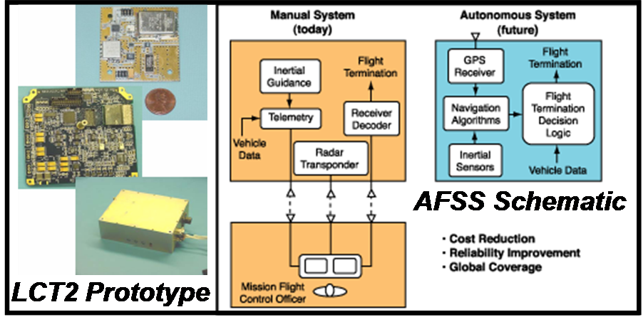
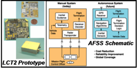
Since 2001, engineers at NASA Wallops Flight Facility have been developing new range technologies, systems and approaches to improve the cost and responsiveness of launch and flight test activities, within the constraints of available funding and program schedules. Specifically, NASA Wallops has been leading two range technology development projects: the Autonomous Flight Safety System (AFSS) and the Low Cost TDRSS Transceiver (LCT2). AFSS is a project to develop an autonomous on-board system that could augment or replace traditional ground-commanded Range Safety flight termination systems. The AFSS would use redundant sensors and processors on board a launch vehicle to monitor its trajectory, and if necessary initiate pyrotechnic devices to terminate the flight. LCT2 is an effort to produce a relatively low-cost transceiver to allow launch vehicles to communicate through NASA's Tracking and Data Relay Satellite System (TDRSS) after they have gone over the horizon from the launch site. LCT2 is being pursued as part of the Space Based Range Demonstration and Certification (SBRDC) program (formerly called Space Based Telemetry and Range Safety (STARS)) in cooperation with NASA Kennedy Space Center. Missions
WFF’s primary mission areas are as follows:
With its sounding rocket, aircraft, and balloon flights carrying scientific payloads, its aeronautical systems testing, its range support for Space Shuttle launches, and its educational outreach activities, WFF supports all of NASA’s Mission Directorates and practically all of their respective themes:
Commercial spaceportIn 1998, the Virginia Commercial Space Flight Authority, later joined by Maryland, built the Mid-Atlantic Regional Spaceport at Wallops on land leased from NASA. In December 2006, the facility made its first launch. Visitor center
The Wallops Visitor Center has a variety of hands-on exhibits and hosts weekly educational activities and programs to enable children to explore and learn about the technologies designed and used by NASA researchers and scientists. In addition, one Saturday each month, NASA invites model rocketry enthusiasts to launch their own rockets from the WFF rocket launch site. NASA personnel also participate, launching models of various rockets and explaining the spacecraft they carry in real life. The schedule for sounding rocket launches from WFF is posted on its official Web site. EducationFor many years WFF was home to the NSIP Sub-SEM and SEM projects. NSIP stands for the NASA Student Involvement Project, the Sub-SEM project was to design one of four experiments that would be inserted into an ORION-II one stage rocket and launched above 98 percent of the atmosphere, and experience over 30 Gs of centrifugal force, while SEM was to design an experiment that would be flown on a future Space Shuttle mission. Each project gave 16 students and four teachers (four students and one teacher from each high school) the opportunity to spend an almost all-expense-paid week at WFF. Normally the students and teachers stayed in the Mariner Motel, now a Holiday Inn, conducting experiments and learning about the facility. Following the presidential mandate and budget cuts the entire NSIP program, SEM and Sub-SEM included, were shut down. AlliancesThe NASA Wallops Flight Facility has alliances with a number of organizations important to its mission and future growth. Some examples include:
Image galleryThe above content comes from Wikipedia and is published under free licenses – click here to read more.
Location & QuickFacts
Owner & Manager
Airport Operations and Facilities
Airport Communications
Airport Services
Runway InformationRunway 04/22
Runway 10/28
Runway 17/35
Radio Navigation Aids
Remarks
Images and information placed above are from We thank them for the data!
We don't guarantee the information is fresh and accurate. The data may
be wrong or outdated.
|
|||||||||||||||||||||||||||||||||||||||||||||||||||||||||||||||||||||||||||||||||||||||||||||||||||||||||||||||||||||||||||||||||||||||||||||||||||||||||||||||||||||||||||||||||||||||||||||||||||||||||||||||||||||||||||||||||||||||||||||||||||||||||||||||||||||||||||||||||||||||||||||||||||||||||||||||||||||||||||||||||||||||||||||||||||||||

 |
|
Copyright 2004-2026 © by Airports-Worldwide.com, Vyshenskoho st. 36, Lviv 79010, Ukraine Legal Disclaimer |