 |
|
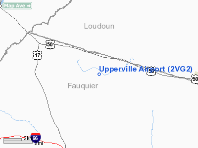
Location & QuickFacts
| FAA Information Effective: | 2008-09-25 |
| Airport Identifier: | 2VG2 |
| Airport Status: | Operational |
| Longitude/Latitude: | 077-52-10.9830W/38-58-18.3940N
-77.869718/38.971776 (Estimated) |
| Elevation: | 551 ft / 167.94 m (Surveyed) |
| Land: | 0 acres |
| From nearest city: | 2 nautical miles SE of Upperville, VA |
| Location: | Fauquier County, VA |
| Magnetic Variation: | 09W (1985) |
Owner & Manager
| Ownership: | Privately owned |
| Owner: | Oak Springs Farm, Llc |
| Address: | 8540 Mill Reef Rd.
Upperville, VA 20184 |
| Phone number: | 540-592-3465 |
| Manager: | Aliene Laws |
| Address: | Oak Spring Farms, 8540 Mill Reef Rd
Upperville, VA 20184 |
| Phone number: | 540-592-3465 |
Airport Operations and Facilities
| Airport Use: | Private |
| Wind indicator: | Yes |
| Segmented Circle: | No |
| Control Tower: | No |
| Lighting Schedule: | PHONE REQ
FOR RWY LGTS CALL 540-592-3211. |
| Landing fee charge: | No |
| Sectional chart: | Washington |
| Region: | AEA - Eastern |
| Boundary ARTCC: | ZDC - Washington |
| Tie-in FSS: | DCA - Leesburg |
| FSS on Airport: | No |
| FSS Toll Free: | 1-800-WX-BRIEF |
Airport Communications
Airport Services
| Airframe Repair: | NONE |
| Power Plant Repair: | NONE |
Runway Information
Runway NW/SE
| Dimension: | 5100 x 100 ft / 1554.5 x 30.5 m |
| Surface: | ASPH, |
| Edge Lights: | Medium |
| |
Runway NW |
Runway SE |
| Traffic Pattern: | Left | Left |
|
Radio Navigation Aids
| ID |
Type |
Name |
Ch |
Freq |
Var |
Dist |
| GDX | NDB | Goodwin Lake | | 227.00 | 08W | 2.1 nm |
| TZ | NDB | Cogan | | 364.00 | 10W | 11.6 nm |
| CJR | NDB | Culpeper | | 252.00 | 09W | 26.5 nm |
| MSQ | NDB | Nailr | | 351.00 | 10W | 31.1 nm |
| LUA | NDB | Caverns | | 245.00 | 09W | 32.6 nm |
| GAI | NDB | Gaithersburg | | 385.00 | 09W | 34.9 nm |
| GTN | NDB | Georgetown | | 323.00 | 09W | 34.9 nm |
| DC | NDB | Oxonn | | 332.00 | 11W | 41.3 nm |
| VKX | NDB | Potomac | | 241.00 | 10W | 44.8 nm |
| EZF | NDB | Shannon | | 237.00 | 10W | 46.7 nm |
| FDK | VOR | Frederick | | 109.00 | 08W | 35.1 nm |
| HGR | VOR | Hagerstown | | 109.80 | 07W | 43.6 nm |
| DCA | VOR/DME | Washington | 047X | 111.00 | 09W | 39.6 nm |
| LDN | VORTAC | Linden | 090X | 114.30 | 06W | 17.2 nm |
| AML | VORTAC | Armel | 082X | 113.50 | 08W | 19.0 nm |
| CSN | VORTAC | Casanova | 110X | 116.30 | 06W | 19.9 nm |
| MRB | VORTAC | Martinsburg | 058X | 112.10 | 07W | 24.9 nm |
| BRV | VORTAC | Brooke | 092X | 114.50 | 09W | 45.3 nm |
| ADW | VORTAC | Andrews | 078X | 113.10 | 10W | 48.0 nm |
| DCA | VOT | Washington National | | 109.40 | | 39.8 nm |
| ADW | VOT | Andrews Afb | | 109.60 | | 47.6 nm |
Images and information placed above are from
http://www.airport-data.com/airport/2VG2/
We thank them for the data!
| General Info
|
| Country |
United States
|
| State |
VIRGINIA
|
| FAA ID |
2VG2
|
| Latitude |
38-58-18.394N
|
| Longitude |
077-52-10.983W
|
| Elevation |
551 feet
|
| Near City |
UPPERVILLE
|
We don't guarantee the information is fresh and accurate. The data may
be wrong or outdated.
For more up-to-date information please refer to other sources.
|
|


