 |
|
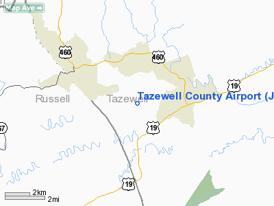
Location & QuickFacts
| FAA Information Effective: | 2008-09-25 |
| Airport Identifier: | JFZ |
| Airport Status: | Operational |
| Longitude/Latitude: | 081-47-53.7700W/37-03-49.4880N
-81.798269/37.063747 (Estimated) |
| Elevation: | 2653 ft / 808.63 m (Surveyed) |
| Land: | 204 acres |
| From nearest city: | 2 nautical miles S of Richlands, VA |
| Location: | Tazewell County, VA |
| Magnetic Variation: | 06W (1995) |
Owner & Manager
| Ownership: | Publicly owned |
| Owner: | Tazewell Co Airport Authority |
| Address: | P.o. Box 170
Cedar Bluff, VA 24609 |
| Phone number: | 276-963-4509 |
| Manager: | Buford Cordle |
| Address: | P.o. Box 170
Cedar Bluff, VA 24609 |
| Phone number: | 276-963-4509 |
Airport Operations and Facilities
| Airport Use: | Open to public |
| Wind indicator: | Yes |
| Segmented Circle: | Yes |
| Control Tower: | No |
| Lighting Schedule: | DUSK-DAWN
MIRL RY 07/25 PRESET LOW INTST; TO INCREASE INTST & ACTVT REIL RYS 07 & 25 & PAPI RY 07/25 - CTAF. |
| Beacon Color: | Clear-Green (lighted land airport) |
| Sectional chart: | Cincinnati |
| Region: | AEA - Eastern |
| Boundary ARTCC: | ZID - Indianapolis |
| Responsible ARTCC: | ZTL - Atlanta |
| Tie-in FSS: | DCA - Leesburg |
| FSS on Airport: | No |
| FSS Toll Free: | 1-800-WX-BRIEF |
| NOTAMs Facility: | 6V3 (NOTAM-d service avaliable) |
| Federal Agreements: | NGY |
Airport Communications
| CTAF: | 123.050 |
| Unicom: | 123.050 |
Airport Services
Runway Information
Runway 07/25
| Dimension: | 4300 x 75 ft / 1310.6 x 22.9 m |
| Surface: | ASPH, |
| Weight Limit: | Single wheel: 12500 lbs.
Dual wheel: 18000 lbs. |
| Edge Lights: | Medium |
| |
Runway 07 |
Runway 25 |
| Longitude: | 081-48-17.9290W | 081-47-29.6120W |
| Latitude: | 37-03-40.7100N | 37-03-58.2740N |
| Elevation: | 2652.00 ft | 2652.00 ft |
| Alignment: | 66 | 127 |
| Traffic Pattern: | Left | Left |
| Markings: | Non-precision instrument, Good Condition | Non-precision instrument, Good Condition |
| Crossing Height: | 0.00 ft | 53.00 ft |
| VASI: | 2-light PAPI on left side | 2-light PAPI on left side |
| Visual Glide Angle: | 4.00° | 4.00° |
| Runway End Identifier: | Yes | Yes |
| Obstruction: | 3 ft tree, 245.0 ft from runway, 91 ft left of centerline, 17:1 slope to clear | 15 ft tree, 328.0 ft from runway, 104 ft left of centerline, 8:1 slope to clear |
|
Radio Navigation Aids
| ID |
Type |
Name |
Ch |
Freq |
Var |
Dist |
| VJ | NDB | Whine | | 236.00 | 05W | 21.1 nm |
| MK | NDB | Suzze | | 335.00 | 06W | 28.0 nm |
| JJO | NDB | Mountain City | | 396.00 | 04W | 38.9 nm |
| GTC | NDB | Guyandot | | 293.00 | 03W | 43.5 nm |
| JU | NDB | Ashee | | 410.00 | 07W | 44.3 nm |
| GZG | VOR/DME | Glade Spring | 039X | 110.20 | 02W | 19.7 nm |
| BLF | VORTAC | Bluefield | 037X | 110.00 | 03W | 32.4 nm |
| HMV | VORTAC | Holston Mountain | 093X | 114.60 | 04W | 40.9 nm |
Remarks
- GCO AVBL ON FREQ 135.075 THRU ZTL CLEARANCE DELIVERY AND DCA AFSS - UNRELIABLE.
Images and information placed above are from
http://www.airport-data.com/airport/JFZ/
We thank them for the data!
|
|


