 |
|
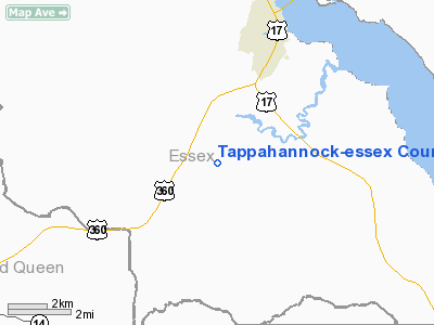
Tappahannock-essex County Airport |
| Tappahannock-Essex County Airport |
| IATA: none – ICAO: KXSA – FAA LID: XSA |
| Summary |
| Airport type |
Public |
| Owner |
Tappahannock Essex County Airport Authority |
| Serves |
Tappahannock, Virginia |
| Location |
Essex County, near Tappahannock, Virginia |
| Elevation AMSL |
136 ft / 41 m |
| Coordinates |
37°51′35″N 076°53′39″W / 37.85972°N 76.89417°W / 37.85972; -76.89417 |
| Website |
TappahannockEssexAirport.com |
| Runways |
| Direction |
Length |
Surface |
| ft |
m |
| 10/28 |
4,300 |
1,311 |
Asphalt |
| Source: Federal Aviation Administration |
Tappahannock-Essex County Airport (ICAO: KXSA, FAA LID: XSA) is a public-use airport located five nautical miles (9 km) south of the central business district of Tappahannock, a town in Essex County, Virginia, United States. It is owned by the Tappahannock Essex County Airport Authority.
Opened in 2007 and located near Route 360 at St. Paul's Crossroads, this airport replaced the former Tappahannock Municipal Airport (FAA LID: W79) which was located near the intersection of Route 17 & Airport Road.
Although most U.S. airports use the same three-letter location identifier for the FAA and IATA, Tappahannock-Essex County Airport is assigned XSA by the FAA but has no designation from the IATA. Facilities
Tappahannock-Essex County Airport covers an area of 423 acres (171 ha) which contains one asphalt paved runway (10/28) measuring 4,300 x 75 ft (1,311 x 23 m).
History
The airport was built by the United States Army Air Force about 1942, and was known as Tappahannock Flight Strip. It was an emergency landing airfield for military aircraft on training flights. It was closed after World War II, and was turned over for local government use by the War Assets Administration (WAA).
The above content comes from Wikipedia and is published under free licenses – click here to read more.
Location & QuickFacts
| FAA Information Effective: | 2008-09-25 |
| Airport Identifier: | XSA |
| Airport Status: | Operational |
| Longitude/Latitude: | 076-53-38.8000W/37-51-34.6000N
-76.894111/37.859611 (Estimated) |
| Elevation: | 135 ft / 41.15 m (Surveyed) |
| Land: | 423 acres |
| From nearest city: | 5 nautical miles S of Tappahannock, VA |
| Location: | Essex County, VA |
| Magnetic Variation: | 10W () |
Owner & Manager
| Ownership: | Publicly owned |
| Owner: | Tappahannock Essex County Arpt Auth |
| Address: | 1450 Aviation Road
Tappahannock, VA 22560 |
| Phone number: | 804-443-5885 |
| Manager: | Charles Bowman |
| Address: | 1450 Aviation Road
Tappahannock, VA 22560 |
| Phone number: | 804-443-5885 |
Airport Operations and Facilities
| Airport Use: | Open to public |
| Wind indicator: | Yes |
| Segmented Circle: | Yes |
| Control Tower: | No |
| Lighting Schedule: | RDO-CTL
ACTVT MIRL RY 10/28, PAPI RYS 10 & 28 AND ARPT BCN - CTAF. |
| Beacon Color: | Yellow (unlighted seaplane base) |
| Sectional chart: | Washington |
| Region: | AEA - Eastern |
| Boundary ARTCC: | ZDC - Washington |
| Responsible ARTCC: | ZDC - Washington |
| Tie-in FSS: | DCA - Leesburg |
| FSS Toll Free: | 1-800-WX-BRIEF |
| Federal Agreements: | NGY |
Airport Communications
| CTAF: | 122.800 |
| Unicom: | 122.800 |
Airport Services
Runway Information
Runway 10/28
| Dimension: | 4300 x 75 ft / 1310.6 x 22.9 m |
| Surface: | ASPH, |
| Edge Lights: | Medium |
| |
Runway 10 |
Runway 28 |
| Longitude: | 076-54-05.5589W | 076-53-12.1004W |
| Latitude: | 37-51-32.9760N | 37-51-36.2093N |
| Elevation: | 135.00 ft | 128.00 ft |
| Alignment: | 86 | 127 |
| Traffic Pattern: | Left | Left |
| Markings: | Non-precision instrument, Good Condition | Non-precision instrument, Good Condition |
| Crossing Height: | 40.00 ft | 40.00 ft |
| VASI: | 2-light PAPI on left side | 2-light PAPI on left side |
| Visual Glide Angle: | 3.00° | 3.00° |
| Runway End Identifier: | Yes | Yes |
|
Radio Navigation Aids
| ID |
Type |
Name |
Ch |
Freq |
Var |
Dist |
| APH | NDB | A P Hill | | 396.00 | 10W | 24.6 nm |
| LJK | NDB | Ashey | | 280.00 | 09W | 28.3 nm |
| NHK | NDB | Patuxent | | 400.00 | 10W | 34.6 nm |
| EZF | NDB | Shannon | | 237.00 | 10W | 35.9 nm |
| CF | NDB | Pubbs | | 392.00 | 09W | 41.4 nm |
| FAF | NDB | Felker | | 226.00 | 08W | 45.3 nm |
| IQK | NDB | Louisa | | 382.00 | 09W | 46.8 nm |
| PJS | NDB | Henry | | 375.00 | 09W | 47.7 nm |
| HCM | VORTAC | Harcum | 025X | 108.80 | 07W | 26.2 nm |
| RIC | VORTAC | Richmond | 088X | 114.10 | 09W | 29.5 nm |
| HPW | VORTAC | Hopewell | 057X | 112.00 | 06W | 33.6 nm |
| PXT | VORTAC | Patuxent | 123X | 117.60 | 10W | 34.8 nm |
| BRV | VORTAC | Brooke | 092X | 114.50 | 09W | 35.9 nm |
| FAK | VORTAC | Flat Rock | 080X | 113.30 | 06W | 48.7 nm |
Images and information placed above are from
http://www.airport-data.com/airport/XSA/
We thank them for the data!
|
|


