 |
|
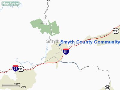
Smyth County Community Hospital Heliport |
Location & QuickFacts
| FAA Information Effective: | 2008-09-25 |
| Airport Identifier: | VG41 |
| Airport Status: | Operational |
| Longitude/Latitude: | 081-30-18.0000W/36-51-09.0000N
-81.505000/36.852500 (Estimated) |
| Elevation: | 2350 ft / 716.28 m () |
| Land: | 2 acres |
| From nearest city: | 2 nautical miles NE of Marion, VA |
| Location: | Smyth County, VA |
| Magnetic Variation: | 07W (2000) |
Owner & Manager
| Ownership: | Privately owned |
| Owner: | Smyth County Community Hospital |
| Address: | 565 Radio Hill Rd
Marion, VA 24354 |
| Phone number: | 540-782-1234 |
| Manager: | Kenny Rich
KENNY RICH - MAINTENANCE DIRECTOR. |
| Address: | P.o. Box 880
Marion, VA 24354 |
| Phone number: | 540-782-1246 |
Airport Operations and Facilities
| Airport Use: | Private |
| Segmented Circle: | No |
| Control Tower: | No |
| Region: | AEA - Eastern |
| Boundary ARTCC: | ZTL - Atlanta |
| Tie-in FSS: | DCA - Leesburg |
| FSS Toll Free: | 1-800-WX-BRIEF |
Runway Information
Helipad H1
| Dimension: | 40 x 40 ft / 12.2 x 12.2 m |
| Surface: | CONC, |
| |
Runway H1 |
Runway |
| Traffic Pattern: | Left | Left |
|
Radio Navigation Aids
| ID |
Type |
Name |
Ch |
Freq |
Var |
Dist |
| MK | NDB | Suzze | | 335.00 | 06W | 13.2 nm |
| VJ | NDB | Whine | | 236.00 | 05W | 22.5 nm |
| JU | NDB | Ashee | | 410.00 | 07W | 26.7 nm |
| JJO | NDB | Mountain City | | 396.00 | 04W | 30.4 nm |
| HLX | NDB | Hillsville | | 269.00 | 06W | 33.3 nm |
| BAR | NDB | Hemlock | | 320.00 | 02W | 45.8 nm |
| UKF | NDB | Wilki | | 209.00 | 06W | 48.6 nm |
| EZT | NDB | Elizabethton | | 275.00 | 02W | 49.0 nm |
| ZEF | NDB | Zephyr | | 326.00 | 05W | 49.7 nm |
| GZG | VOR/DME | Glade Spring | 039X | 110.20 | 02W | 27.7 nm |
| BLF | VORTAC | Bluefield | 037X | 110.00 | 03W | 31.1 nm |
| HMV | VORTAC | Holston Mountain | 093X | 114.60 | 04W | 39.1 nm |
| PSK | VORTAC | Pulaski | 115X | 116.80 | 06W | 40.6 nm |
Remarks
- PRVDD CLEAR 8:1 SLOPE, COMPLIANCE W/FAR PART 77.29B, APPROPRIATE INGRESS/EGRESS MKGS & LGTD WINDSOCK FOR NGT OPNS, VEHICULAR TFC AROUND SITE CONTROLLED.
Images and information placed above are from
http://www.airport-data.com/airport/VG41/
We thank them for the data!
| General Info
|
| Country |
United States
|
| State |
VIRGINIA
|
| FAA ID |
VG41
|
| Latitude |
36-51-09.000N
|
| Longitude |
081-30-18.000W
|
| Elevation |
2350 feet
|
| Near City |
MARION
|
We don't guarantee the information is fresh and accurate. The data may
be wrong or outdated.
For more up-to-date information please refer to other sources.
|
|


