 |
|
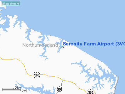
Location & QuickFacts
| FAA Information Effective: | 2008-09-25 |
| Airport Identifier: | 3VG3 |
| Airport Status: | Operational |
| Longitude/Latitude: | 076-20-54.9900W/37-56-09.9900N
-76.348608/37.936108 (Estimated) |
| Elevation: | 10 ft / 3.05 m () |
| Land: | 0 acres |
| From nearest city: | 4 nautical miles SW of Burgess, VA |
| Location: | Northumberland County, VA |
| Magnetic Variation: | 11W (2000) |
Owner & Manager
| Ownership: | Privately owned |
| Owner: | Serenity Farm |
| Address: | 2109 Mob Neck Rd
Northumberland County, VA 22039 |
| Phone number: | 703-690-7452 |
| Manager: | David S. Watrous |
| Address: | 13756 Charismatic Way
Gainesville, VA 20155 |
| Phone number: | 703-690-7452 |
Airport Operations and Facilities
| Airport Use: | Private |
| Wind indicator: | Yes |
| Segmented Circle: | No |
| Control Tower: | No |
| Sectional chart: | Washington |
| Region: | AEA - Eastern |
| Boundary ARTCC: | ZDC - Washington |
| Tie-in FSS: | DCA - Leesburg |
| FSS Toll Free: | 1-800-WX-BRIEF |
Runway Information
Runway 14/32
| Dimension: | 2600 x 75 ft / 792.5 x 22.9 m |
| Surface: | TURF, |
| |
Runway 14 |
Runway 32 |
| Traffic Pattern: | Left | Left |
| Obstruction: | 50 ft trees, 200.0 ft from runway | 50 ft trees, 50.0 ft from runway |
|
Radio Navigation Aids
| ID |
Type |
Name |
Ch |
Freq |
Var |
Dist |
| NHK | NDB | Patuxent | | 400.00 | 10W | 21.2 nm |
| BDB | NDB | Accomack | | 336.00 | 11W | 34.2 nm |
| CGE | NDB | Cambridge | | 355.00 | 10W | 39.2 nm |
| APH | NDB | A P Hill | | 396.00 | 10W | 47.1 nm |
| PJS | NDB | Henry | | 375.00 | 09W | 48.8 nm |
| FAF | NDB | Felker | | 226.00 | 08W | 49.6 nm |
| PXT | VORTAC | Patuxent | 123X | 117.60 | 10W | 21.3 nm |
| HCM | VORTAC | Harcum | 025X | 108.80 | 07W | 34.0 nm |
| CCV | VORTAC | Cape Charles | 059X | 112.20 | 10W | 39.1 nm |
| SWL | VORTAC | Snow Hill | 071X | 112.40 | 08W | 42.5 nm |
| SBY | VORTAC | Salisbury | 049X | 111.20 | 12W | 46.6 nm |
| OTT | VORTAC | Nottingham | 084X | 113.70 | 10W | 49.9 nm |
Remarks
- PRVDD VFR ONLY CLEAR 20:1 APCH PATH, C00-ORD FLGT PATTERN WITH 2 PVT ARPTS IN CLOSE PROXIMITY.
Images and information placed above are from
http://www.airport-data.com/airport/3VG3/
We thank them for the data!
| General Info
|
| Country |
United States
|
| State |
VIRGINIA
|
| FAA ID |
3VG3
|
| Latitude |
37-56-09.990N
|
| Longitude |
076-20-54.990W
|
| Elevation |
10 feet
|
| Near City |
BURGESS
|
We don't guarantee the information is fresh and accurate. The data may
be wrong or outdated.
For more up-to-date information please refer to other sources.
|
|


