 |
|
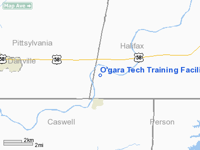
O'gara Tech Training Facility Heliport |
Location & QuickFacts
| FAA Information Effective: | 2008-09-25 |
| Airport Identifier: | VA40 |
| Airport Status: | Operational |
| Longitude/Latitude: | 079-12-16.0000W/36-33-54.8000N
-79.204444/36.565222 (Estimated) |
| Elevation: | 385 ft / 117.35 m (Estimated) |
| Land: | 0 acres |
| From nearest city: | 14 nautical miles ES of Danville, VA |
| Location: | Pittsylvania County, VA |
| Magnetic Variation: | () |
Owner & Manager
| Ownership: | Privately owned |
| Owner: | The O'gara Group |
| Address: | 1120 Euro Rally Road
Alton, VA 24520 |
| Phone number: | 434-822-9166 |
| Manager: | The O'gara Group |
| Address: | 1120 Euro Rally Road
Alton, VA 24520 |
| Phone number: | 434-822-9166 |
Airport Operations and Facilities
| Airport Use: | Private |
| Wind indicator: | Yes |
| Control Tower: | No |
| Sectional chart: | Cincinnati |
| Region: | AEA - Eastern |
| Boundary ARTCC: | ZDC - Washington |
| Responsible ARTCC: | ZDC - Washington |
| Tie-in FSS: | DCA - Leesburg |
| FSS Toll Free: | 1-800-WX-BRIEF |
Runway Information
Helipad H1
| Dimension: | 700 x 300 ft / 213.4 x 91.4 m |
| Surface: | TURF, |
| |
Runway H1 |
Runway |
| Traffic Pattern: | Left | Left |
|
Radio Navigation Aids
| ID |
Type |
Name |
Ch |
Freq |
Var |
Dist |
| OQA | FAN MARKER | Rockingham County | | | | 31.3 nm |
| HUR | NDB | Person | | 220.00 | 08W | 21.0 nm |
| SIF | NDB | Slammer | | 423.00 | 07W | 29.2 nm |
| HXO | NDB | Huntsboro | | 271.00 | 07W | 32.5 nm |
| UV | NDB | Bales | | 396.00 | 07W | 34.4 nm |
| HB | NDB | Himun | | 361.00 | 08W | 39.8 nm |
| LY | NDB | Bojar | | 385.00 | 08W | 42.0 nm |
| LE | NDB | Leevy | | 350.00 | 07W | 44.9 nm |
| TOX | NDB | Siler City | | 371.00 | 07W | 49.9 nm |
| DAN | VOR | Danville | | 113.10 | 06W | 6.4 nm |
| SBV | VORTAC | South Boston | 041X | 110.40 | 05W | 11.3 nm |
| LYH | VORTAC | Lynchburg | 029X | 109.20 | 05W | 41.5 nm |
| RDU | VORTAC | Raleigh/durham | 119X | 117.20 | 04W | 46.4 nm |
| GSO | VORTAC | Greensboro | 109X | 116.20 | 03W | 48.7 nm |
| LIB | VORTAC | Liberty | 077X | 113.00 | 03W | 49.4 nm |
Remarks
- 40 FT MKD PLINE RUNS NORTH AND SOUTH LCTD ON THE FAR WEST SIDE OF THE PAD.
- THIS HELIPAD CO-LCTD WITH A PARACHUTE DROP ZONE LCTD ON THE PROPERTY OF THE VA INTL RACEWAY.
- PRVDD VFR CONDS, PVT USE, AREA MARKED AND WIND INDICATOR IS MAINTAINED.
Images and information placed above are from
http://www.airport-data.com/airport/VA40/
We thank them for the data!
| General Info
|
| Country |
United States
|
| State |
VIRGINIA
|
| FAA ID |
VA40
|
| Latitude |
36-55-00.530N
|
| Longitude |
075-59-58.750W
|
| Elevation |
15 feet
|
| Near City |
FORT STORY(VIRGINIA BEACH)
|
We don't guarantee the information is fresh and accurate. The data may
be wrong or outdated.
For more up-to-date information please refer to other sources.
|
|


